Santa Clarita Valley
The Santa Clarita Valley (SCV) is part of the upper watershed of the Santa Clara River in Southern California. The valley was part of the 48,612-acre (19,673 ha) Rancho San Francisco Mexican land grant. Located in Los Angeles County, its main population center is the city of Santa Clarita which includes the communities of Canyon Country, Newhall, Saugus, and Valencia. Adjacent unincorporated communities include Castaic, Stevenson Ranch, Val Verde, and the new master planned community of Newhall Ranch.
| Santa Clarita Valley | |
|---|---|
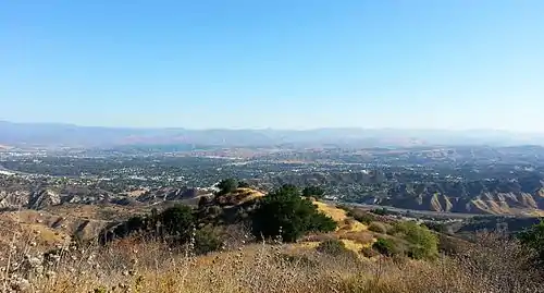
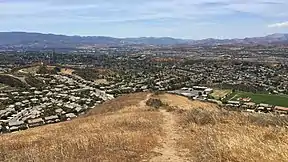 View from the Sierra Pelona Mountains | |
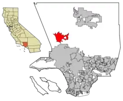 Santa Clarita in Los Angeles County | |
| Floor elevation | 1,300 feet (400 m) |
| Naming | |
| Native name | Spanish: Valle de Santa Clarita |
| Geography | |
| Location | California, United States |
| Population centers | Santa Clarita |
| Traversed by | Interstate 5, California Highway 14 |
| Rivers | Santa Clara River |
Geography
The Santa Clarita Valley is bordered by the Lake Piru area, including the community of Val Verde, Los Padres National Forest, and Castaic Lake to the northwest, Sierra Pelona Mountains and Angeles National Forest to the north and northeast, San Gabriel Mountains to the east and southeast, and Santa Susana Mountains to the south and southwest, and Ventura County and the Santa Clara River Valley to the west. To the west-northwest lies the Topatopa Mountains.
Santa Clarita Valley is connected to a wide array of other nearby valleys: the San Fernando Valley and Los Angeles Basin via Newhall Pass to the south; Antelope Valley via CA 14 through Soledad Pass to the northeast; the San Joaquin Valley via I-5 through Tejon Pass to the northwest, and Leona Valley via San Francisquito and Bouquet canyons.
Downstream lies the Santa Clara River Valley, which was given the moniker Heritage Valley by the tourism bureau representing Piru, Fillmore, and Santa Paula. Upstream is Soledad Canyon which contains the communities of Vincent, Acton, Ravenna, and Agua Dulce.
The valley is part of a "wind-tunnel-like-corridor" that connects the high desert with the Oxnard Plain on the coast. This funnels the Santa Ana winds which spreads wildfires and has been called one of the "most dangerous wind and fire corridors in Southern California." This served to spread the Maria Fire, one of the 2019 California wildfires.[1]
Name
The Santa Clara River was named by Spanish explorers for Claire of Assisi. The valley later became known as "little Santa Clara" in deference to the Northern California mission and city of Santa Clara, California. In time, "little Santa Clara" became "Santa Clarita."[2]
Entertainment
The Santa Clarita Valley is about 20 miles from the Burbank Bob Hope Airport, and about 35 miles from the Los Angeles International Airport.[3] It is home to the 262-acre theme park Six Flags Magic Mountain and the gated waterpark Six Flags Hurricane Harbor. It offers a variety of family-oriented activity centers such as the Mountasia Family Fun Center, Copper Horse Riding Ranch and the Ice Station Valencia, restaurants and shopping centers, golf courses, cinemas and theaters, luxurious day spas, outdoor recreation areas like Castaic Lake, Placerita Canyon, and Towsley Canyon Park, as well as acres of parkland, animal sanctuaries like the Gentle Barn and Gibbon Conservation Center, over 70 miles of paseos and trails for hiking and biking, and more. Santa Clarita is also home to a number of historical sites, such as the oil drilling town Mentryville, Walk of Western Stars, and William S. Hart Ranch and Museum. The Santa Clarita Valley has a rich Western heritage, and since 1994, it has hosted an annual Cowboy Festival, which attracts more than 10,000 visitors each year.[4]
Schools
The Santa Clarita Valley is home to many school districts such as Acton-Agua Dulce Unified School District, Castaic Union School District, Newhall School District, Saugus Union School District, Sulphur Springs School District, and William S. Hart Union High School District, with several elementary, junior high, and high schools within these districts.[5] Many of the schools in these districts have been awarded with the California Distinguished and National Blue Ribbon School Award.[6] The Santa Clarita Valley also includes three colleges. One is a private university called The California Institute of the Arts, otherwise known as CalArts, which is located in Valencia. CalArts is run by President Ravi Rajan.[7] The second college is College of the Canyons which is a public two-year community college that operates within the Santa Clarita Community College District. The college’s main campus is located in Valencia with a smaller satellite campus located in Canyon Country. Dr. Dianne G. Van Hook is president of the college and chancellor of the Santa Clarita Community College District. The Master's University is a private Christian college also located in the Santa Clarita Valley.[8]
See also
References
- Fry, Hannah; Puente, Mark; Lin II, Rong-Gong; Wigglesworth, Alex (2019-11-01). "Maria fire charges toward Santa Paula neighborhoods, forcing additional evacuations". Los Angeles Times. Retrieved 2019-11-01.
- Newhall., Ruth Waldo (February–March 1997). "How Santa Clarita Got Its Name". Old Town Newhall Gazette. Retrieved 22 March 2018 – via www.scvhistory.com.
- "Transportation". Visit Santa Clarita. Retrieved 25 October 2017.
- "About – Cowboy Festival". cowboyfestival.org. Retrieved 2016-02-14.
- "Schools in Santa Clarita | City of Santa Clarita, CA". www.santa-clarita.com. Retrieved 2017-10-25.
- "National Blue Ribbon Schools Program" (PDF). U.S. Department of Education.
- "Visit CalArts". CalArts.
- "Canyons Home". College of the Canyons Website.
External links
| Wikivoyage has a travel guide for Santa Clarita Valley. |
| City | |
|---|---|
| Neighborhoods | |
| Schools | |
| Colleges and universities | |
| Points of interest | |
| Services | |
| Media | |
| Transportation | |
| History | |
| Companies | |