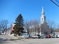
Lanoraie, Quebec
Lanoraie is a town in the Lanaudière region of Quebec, Canada, part of the D'Autray Regional County Municipality.
Lanoraie | |
|---|---|
 | |
 Coat of arms | |
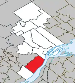 Location within D'Autray RCM | |
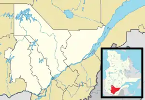 Lanoraie Location in central Quebec | |
| Coordinates: 45°58′N 73°13′W[1] | |
| Country | Canada |
| Province | Quebec |
| Region | Lanaudière |
| RCM | D'Autray |
| Settled | 1732 |
| Constituted | December 6, 2000 |
| Government | |
| • Mayor | Gérard Jean[3] |
| • Federal riding | Berthier—Maskinongé |
| • Prov. riding | Berthier |
| Area | |
| • Total | 115.40 km2 (44.56 sq mi) |
| • Land | 103.08 km2 (39.80 sq mi) |
| Population (2016)[4] | |
| • Total | 4,787 |
| • Density | 46.4/km2 (120/sq mi) |
| • Pop 2011-2016 | |
| • Dwellings | 1,963 |
| Time zone | UTC−5 (EST) |
| • Summer (DST) | UTC−4 (EDT) |
| Postal code(s) | J0K 1E0 |
| Area code(s) | 450 and 579 |
| Highways | |
| Website | www |
History
When Jacques Cartier passed through in the 16th century, the Iroquois had already established themselves in the area, calling it Agochanda or Agouchonda, meaning "place where one stops to eat and rest". It was also in this area in 1642 that Isaac Jogues was abducted by the Mohawks along with Guillaume Couture and René Goupil, and taken into captivity and tortured.[1]
In 1672, the Intendant of New France Jean Talon granted the territory as a seignory to Louis de Niort de La Noraye (1639-1708). In 1688, the Seignory of La Noraye (also spelled as: Lanauraie, Lanoraie, Noraye) was united with the Autray Seignory, granted in 1637 to Jean Bourdon who passed it on to his son Jacques Bourdon d'Autray in 1653.[1]
Although the Parish of Saint-Joseph-de-Lanoraie was founded in 1732, it did not really begin to develop until 1831. In 1845, this parish was incorporated as the Parish Municipality of Lanoraie, but abolished two years later in 1847, when it became part of the Berthier County Municipality. In 1855, it was reestablished as the Parish Municipality of Saint-Joseph-de-Lanoraie. In 1848, the Municipality of Lanoraie-d'Autray was formed.[1]
On December 6, 2000, the Parish Municipality of Saint-Joseph-de-Lanoraie and the Municipality of Lanoraie-d'Autray were merged to form the new Municipality of Lanoraie.[1]
Demographics
Population trend:[5]
- Population in 2011: 4447 (2006 to 2011 population change: 9.3%)
- Population in 2006: 4067
- Population in 2001: 3869
- Population total in 1996: 3759
- Lanoraie-d'Autray: 1904
- Saint-Joseph-de-Lanoraie: 1855
- Population in 1991:
- Lanoraie-d'Autray: 1793
- Saint-Joseph-de-Lanoraie: 1562
Private dwellings occupied by usual residents: 1837 (total dwellings: 1941)
Mother tongue:
- English as first language: 1.0%
- French as first language: 95.2%
- English and French as first language: 0%
- Other as first language: 3.8%
Education
Commission scolaire des Samares operates francophone public schools, including:
- École de la Source d'Autray[6]
The Sir Wilfrid Laurier School Board operates anglophone public schools, including:
- Joliette Elementary School in Saint-Charles-Borromée[7]
- Joliette High School in Joliette[8]
See also
References
- "Lanoraie (Municipalité)" (in French). Commission de toponymie du Québec. Retrieved 2009-11-02.
- Geographic code 52017 in the official Répertoire des municipalités (in French)
- Bellemare, Pierre (November 4, 2013). "Gérard Jean devient maire de Lanoraie". L'Action d'Autray. Archived from the original on March 3, 2016. Retrieved November 6, 2013.
- Statistics Canada 2016 Census - Lanoraie census profile
- Statistics Canada: 1996, 2001, 2006, 2011 census
- "de la Source d'Autray." Commission scolaire des Samares. Retrieved on September 23, 2017.
- "JOLIETTE ELEMENTARY ZONE." Sir Wilfrid Laurier School Board. Retrieved on September 17, 2017.
- "Joliette High School Zone Sec 1-5." Sir Wilfrid Laurier School Board. Retrieved on September 5, 2017.
External links
![]() Media related to Lanoraie at Wikimedia Commons
Media related to Lanoraie at Wikimedia Commons
Adjacent Municipal Subdivisions | |
|---|---|
| Cities & Towns | |
|---|---|
| Municipalities | |
| Parishes | |
| |
| Authority control |
|---|