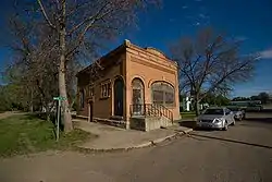
Carpio, North Dakota
Carpio is a city in Ward County, North Dakota, United States. The population was 157 at the 2010 census.[5] It is part of the Minot Micropolitan Statistical Area. Carpio was founded in 1898. It is commonly believed that the town was named after the first post office which operated out of a railcar - hence 'Car P.O.'.[6]
Carpio, North Dakota | |
|---|---|
 | |
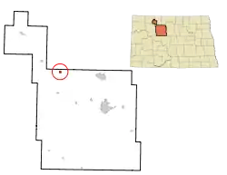 Location of Carpio, North Dakota | |
| Coordinates: 48°26′32″N 101°42′53″W | |
| Country | United States |
| State | North Dakota |
| County | Ward |
| Government | |
| • mayor | Gregg Dahle |
| Area | |
| • Total | 0.63 sq mi (1.64 km2) |
| • Land | 0.63 sq mi (1.64 km2) |
| • Water | 0.00 sq mi (0.00 km2) |
| Elevation | 1,696 ft (517 m) |
| Population | |
| • Total | 157 |
| • Estimate (2019)[3] | 142 |
| • Density | 224.33/sq mi (86.67/km2) |
| Time zone | UTC-6 (Central (CST)) |
| • Summer (DST) | UTC-5 (CDT) |
| ZIP code | 58725 |
| Area code(s) | 701 |
| FIPS code | 38-12260 |
| GNIS feature ID | 1028284[4] |
Geography
Carpio is located at 48°26′32″N 101°42′53″W (48.442087, -101.714812).[7] According to the United States Census Bureau, the city has a total area of 0.59 square miles (1.53 km2), all land.[8]
Demographics
| Historical population | |||
|---|---|---|---|
| Census | Pop. | %± | |
| 1910 | 257 | — | |
| 1920 | 244 | −5.1% | |
| 1930 | 344 | 41.0% | |
| 1940 | 322 | −6.4% | |
| 1950 | 194 | −39.8% | |
| 1960 | 199 | 2.6% | |
| 1970 | 215 | 8.0% | |
| 1980 | 244 | 13.5% | |
| 1990 | 178 | −27.0% | |
| 2000 | 148 | −16.9% | |
| 2010 | 157 | 6.1% | |
| 2019 (est.) | 142 | [3] | −9.6% |
| U.S. Decennial Census[9] 2018 Estimate[10] | |||
2010 census
As of the census[2] of 2010, there were 157 people, 71 households, and 40 families residing in the city. The population density was 266.1 inhabitants per square mile (102.7/km2). There were 83 housing units at an average density of 140.7 per square mile (54.3/km2). The racial makeup of the city was 99.4% White and 0.6% Native American.
There were 71 households, of which 26.8% had children under the age of 18 living with them, 47.9% were married couples living together, 2.8% had a female householder with no husband present, 5.6% had a male householder with no wife present, and 43.7% were non-families. 36.6% of all households were made up of individuals, and 12.7% had someone living alone who was 65 years of age or older. The average household size was 2.21 and the average family size was 2.93.
The median age in the city was 43.5 years. 21.7% of residents were under the age of 18; 5.7% were between the ages of 18 and 24; 25.5% were from 25 to 44; 26.2% were from 45 to 64; and 21% were 65 years of age or older. The gender makeup of the city was 56.7% male and 43.3% female.
2000 census
As of the census of 2000, there were 148 people, 67 households, and 39 families residing in the city. The population density was 251.3 people per square mile (96.9/km2). There were 90 housing units at an average density of 152.8 per square mile (58.9/km2). The racial makeup of the city was 100.00% White. 61.1% were of Norwegian and 21.4% German ancestry.
There were 67 households, out of which 22.4% had children under the age of 18 living with them, 55.2% were married couples living together, 1.5% had a female householder with no husband present, and 40.3% were non-families. 37.3% of all households were made up of individuals, and 16.4% had someone living alone who was 65 years of age or older. The average household size was 2.21 and the average family size was 2.98.
In the city, the population was spread out, with 24.3% under the age of 18, 2.0% from 18 to 24, 26.4% from 25 to 44, 19.6% from 45 to 64, and 27.7% who were 65 years of age or older. The median age was 42 years. For every 100 females, there were 120.9 males. For every 100 females age 18 and over, there were 115.4 males.
The median income for a household in the city was $22,344, and the median income for a family was $39,375. Males had a median income of $28,750 versus $21,250 for females. The per capita income for the city was $15,397. There were 10.8% of families and 11.2% of the population living below the poverty line, including 11.4% of under eighteens and 12.2% of those over 64.
Climate
This climatic region is typified by large seasonal temperature differences, with warm to hot (and often humid) summers and cold (sometimes severely cold) winters. According to the Köppen Climate Classification system, Carpio has a humid continental climate, abbreviated "Dfb" on climate maps.[11]
References
- "2019 U.S. Gazetteer Files". United States Census Bureau. Retrieved July 27, 2020.
- "U.S. Census website". United States Census Bureau. Retrieved June 14, 2012.
- "Population and Housing Unit Estimates". United States Census Bureau. May 24, 2020. Retrieved May 27, 2020.
- "US Board on Geographic Names". United States Geological Survey. October 25, 2007. Retrieved January 31, 2008.
- "2010 Census Redistricting Data (Public Law 94-171) Summary File". American FactFinder. United States Census Bureau. Retrieved May 2, 2011.
- Wick, Douglas A. "Carpio (Ward County)". North Dakota Place Names. Retrieved May 7, 2011.
- "US Gazetteer files: 2010, 2000, and 1990". United States Census Bureau. February 12, 2011. Retrieved April 23, 2011.
- "US Gazetteer files 2010". United States Census Bureau. Archived from the original on July 2, 2012. Retrieved June 14, 2012.
- United States Census Bureau. "Census of Population and Housing". Retrieved October 23, 2013.
- "Population Estimates". United States Census Bureau. Retrieved September 10, 2019.
- Climate Summary for Carpio, North Dakota
Municipalities and communities of Ward County, North Dakota, United States | ||
|---|---|---|
| Cities | 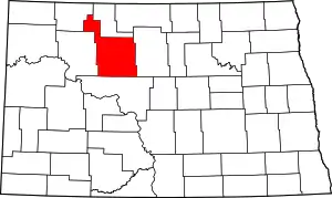 Map of North Dakota highlighting Ward County | |
| Townships | ||
| CDPs | ||
| Unincorporated communities |
| |
| Indian reservation | ||
| Footnotes | ‡This populated place also has portions in an adjacent county or counties | |
| ||

| Authority control |
|---|