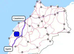
Casablanca–Agadir expressway
The Autoroute Casablanca–Agadir is a new main road in Morocco. Building began in 2000 and the road was inaugurated on 21 June 2010 by Prince Moulay Rachid.[1]
| |
|---|---|
 | |
| Route information | |
| Length | 453 km (281 mi) |
| Existed | 2000–present |
| History | Completed on 21 June 2010 |
| Major junctions | |
| North end | Casablanca |
| South end | Agadir |
| Highway system | |
| Roads of Morocco
| |

The road is 453 km (281 mi) long and connects the cities of Casablanca and Agadir through the city of Marrakesh and High Atlas mountains.
Casablanca–Marrakesh
It has been designated A3 as its identity marker. Total length is 219 km: 57 km Casablanca–Settat and 162 km Settat–Marrakech[2]
The expressway takes its origins south of the residential area of Casablanca, at the interchange with the A1 Rabat–Safi expressway. It continues south past Bouskoura and serves the Mohamed V airport with an exit. A toll station is placed just south of there. The road then circumvales the town of Berrechid serving it with an exit north of it for south-bound traffic and one south of it for north-bound traffic.
The road was opened in 2002 to Settat, and construction on the remaining part started in 2003 reaching Marrakesh in 2007. In 2005 the 17 km bypass of Settat opened.[3] When the Marrakech–Agadir expressway opened in 2009 it was directly connected to this A3.
The Casablanca–Marrakesh highway was completed and opened to traffic on April 17, 2007.[4]
Toll-revenues of this road, including the Casablanca bypass, totaled 219 million dirhams, reaching 3rd spot of top earners[5]
Marrakesh–Agadir
Financial
In June 2004 the Moroccan operator of expressways ADM signed an agreement with the Hasan II Society for economic and social development for a refinancing scheme of the ADM. This financial injection made construction of new roads possible and construction started in 2006.[6]
The road is a toll road or péage to pay back the investments.
Beside the ADM several other parties are involved. Some major investors participate in specific sections of the road or a general goal.
The main investors are (in million dirham)[6][7]
- BID - Islamic Bank for Development - 965 MDH
- FADES -Arab Fund for social and economic development - 920
- FKDEA- Kuwait Fund for Arab and Economic Development - 450
- BAD - African Bank for Development - 1315
- JBIC- Japan Bank for International Cooperation - 1370
Overview
Below is a short overview of the different sub-projects, the costs[8] (against the estimated costs[9]) and the main contractors for that section. For some sections, only contractors for initial work are reported.
| # | from | via | to | length | real and (est cost) in M Dh | contractors | from |
|---|---|---|---|---|---|---|---|
| 1 | Marrakesh | – | Marrakesh West Interchange | 33 km | 583 (783) | El Hajji Srfiani The Arab Contractors | |
| 2 | Marr. West Interchg. | - | Chichaoua | 51 km | 810 (1060) | Burhan | |
| 3 | Chichaoua | – | Imintanoute | 33 km | 753 (975) | SEPROB SNCE | |
| 4 | Imintanout | PK13 | Argana | 59 km | 2125 (2644) | TECNOVIA COVEC | |
| 5 | Argana | PK 20 | Ameskroud | 46 km | 1754 (2132) | DOGUS | |
| 6 | Ameskroud | - | Agadir | 11 km | 287 (293) | Planum Mostogradnja |
Construction
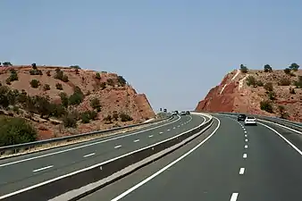
Work is divided into several main sections, each with their own contractors and workers. Construction of a 4-lane motorway through the mountains of the High Atlas requires many structures as fly-overs, viaducts and bridges. The existing national road (route nationale) is used for transportation of building material etc. Along this route, new exits and side roads are constructed to several main working locations and temporary factories (concrete, storage, camp-sites for builders, etc.).
The new road crosses the existing road several times and follows more or less the same route through the mountains.
Layout
Over the full length the new autoroute has:
- two standard traffic lanes in each direction, each 3.5 meters wide with a central separation zone of at least 3 meters
- one emergency lane / hard shoulder in each direction of 1.5 meters wide
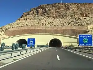
The road has 8 exits/entries, 9 toll-port gates and 4 rest stops with petrol stations, cafés and a room or building for praying. Thirteen viaducts and one tunnel were built to complete the road (excluding viaducts built over the road and/or tunnels under the road for crossing inferior local roads or feet-bridges: if you include these another 100 structures can be included.[8]
Toll road
As (nearly) all Moroccan expressways this new section is also a toll road.
The existing national road will remain open as a toll-free alternative for the autoroute as well as allowing access to smaller villages and roads. Traveling time between Marrakesh and Agadir will be reduced greatly as the autoroute allows overtaking everywhere (4 lane), bypasses villages and allows higher speeds. Possible speed on 2-lane national roads is often greatly reduced due to very slow lorries crawling up a hill while steep bends and traffic from the other side make overtaking hazardous or impossible.
The Marrakesh–Agadir section completes a north-south corridor of expressways that shortens the travel-distance on the route Tangier to Agadir by nearly 50 km (via toll-roads the distance is 776 and via the Route Nationale 824 km. But the biggest save is driving-time: the average travelling time Tangier–Agadir over national (free) roads is 14.5 hours while the same via the different toll-roads is under 7.5 hours[8]
Route
The total length of the expressway is 453 km (281 mi).
 Junction between A3 and N11 : Casablanca-Sidi Maârouf / Casablanca-Center (km 0)
- Junction between A3 and A1 : Port of Casablanca / Had Soualem / El Jadida / Rabat / Tangier / Oujda (km 0)
 32 at 2 kilometres (1.2 mi) : Bouskoura-Ville Verte
- 39 at 9 kilometres (5.6 mi) : Bouskoura-Centre
- 315 at 15 kilometres (9.3 mi) : Mohammed V Airport / Nouaceur
 Bouskoura Toll Station (Agadir - Casablanca direction) (km 16)
- North-Berrechid Toll Station (Casablanca - Agadir direction) (km 23) + 323 at 23 kilometres (14 mi) : North Berrechid (Casablanca - Agadir direction)
- Junction between A3 and A4 : Khouribga / Beni Mellal
- 334 at 34 kilometres (21 mi) : Berrechid-Center / Khouribga / Beni Mellal via route nationale — N11
- South Berrechid Toll Station
 Berrechid (km 37)
- 354 at 54 kilometres (34 mi) : Settat-North
- 367 at 67 kilometres (42 mi) : Settat-Center / El Borouj
- Settat (both directions) (km 78)
- Oued Oum Rabbia (Agadir - Casablanca direction) (km 109)
- 3129 at 129 kilometres (80 mi) : Skhour Rehamna
- Ben Guerir (Casablanca - Agadir direction) /
 Ben Guerir (Agadir - Casablanca direction) (km 154)
 - 3161 at 161 kilometres (100 mi) : Ben Guerir / Youssoufia / El Kelaa des Sraghna
- Sidi Bou Othmane (Casablanca - Agadir direction) / Sidi Bou Othmane (Agadir - Casablanca direction) (km 193)
- 3161 at 200 kilometres (120 mi) : Marrakech-Palmeraie
- 3214 at 214 kilometres (133 mi) : Marrakech-Tamansourt / Youssoufia / Safi / El Jadida via N7
- Marrakech (both directions) (km 229)
- 3232 at 232 kilometres (144 mi) : Marrakech-Targa
- 3248 at 248 kilometres (154 mi) : Marrakech-Loudaya
- Chichaoua (both directions) (km 278)
- 3282 at 282 kilometres (175 mi) : Chichaoua / Essaouira (via R207 toll-free expressway)
- 3309 at 309 kilometres (192 mi) : Imintanoute
 Zaouiat Ait Mellal Tunnel (km 325)
- Argana (both directions) (km 345)
- 3370 at 370 kilometres (230 mi) : Argana
- Idmine (Casablanca - Agadir direction) (km 402)
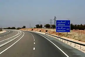
- Ameskroud Toll Station (km 419)
- 3421 at 421 kilometres (262 mi) : Ameskroud / Taroudant (via toll-free expressway)
- Ameskroud : Espace Afriquia Agadir - Haliopolis (both direction) (km 423)
- 3429 at 429 kilometres (267 mi) : N1 — Agadir / Tiznit / Laayoune
Sources and footnotes
- Press-release Inauguration new Agadir-Marrakesh road Archived 2011-06-22 at the Wayback Machine, visited 25 June 2010
- ADM's PDF publication: 2007 in figures Archived 2011-07-20 at the Wayback Machine, visited 23 August 2008
- Important dates Archived March 7, 2012, at the Wayback Machine on ADM website, visited 23 August 2008
- Opening of completed road by king Archived 2011-07-16 at the Wayback Machine
- Main financial figures Archived 2010-04-13 at the Wayback Machine on ADM's website, visited 23 August 2008
- Details from Project page Archived 2008-08-01 at the Wayback Machine on ADM site
- Article on Made in Morocco site Archived May 15, 2007, at the Wayback Machine
- Source: Information for the press regarding Agadir-Marrakesh Archived 2010-07-04 at the Wayback Machine published by the ADM, downloaded 25 June 2010.
- Information from ADM site on Marakech-Agadir project Archived 2008-09-16 at the Wayback Machine