Central Coast Council (Tasmania)
Central Coast Council is a local government body in Tasmania, situated in the north-west of the state between Burnie and Devonport. Central Coast is classified as an urban local government area and has a population of 21,904,[1] Ulverstone and Penguin are the two primary towns of the region.
| Central Coast Council Tasmania | |||||||||||||||
|---|---|---|---|---|---|---|---|---|---|---|---|---|---|---|---|
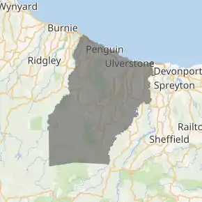
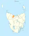
Map showing the Central Coast local government area. | |||||||||||||||
| Coordinates | 41.28°S 146.041°E | ||||||||||||||
| Population | 21,904 (2018)[1] | ||||||||||||||
| • Density | 23.477/km2 (60.81/sq mi) | ||||||||||||||
| Established | 2 April 1993[2] | ||||||||||||||
| Area | 933 km2 (360.2 sq mi)[1] | ||||||||||||||
| Mayor | Jan Bonde | ||||||||||||||
| Council seat | Central Coast, Tasmania | ||||||||||||||
| Region | Ulverstone and Penguin area | ||||||||||||||
| State electorate(s) | Braddon | ||||||||||||||
| Federal Division(s) | Braddon | ||||||||||||||
| |||||||||||||||
History and attributes
The Central Coast Council was established on 2 April 1993 after the amalgamation of the Penguin and Ulverstone municipalities.[2]
Central Coast is classified as urban, regional and small (URS) under the Australian Classification of Local Governments.[3]
The municipal boundaries are the Blythe River in the west, Braddons Lookout Road in the east and Black Bluff in the south.[4] The Central Coast includes the tourist destinations Leven Canyon[5] and Black Bluff,[6] as well as a number of rural areas such as Upper Castra.
Government
| Name | Position[7] | Party affiliation | |
|---|---|---|---|
| Jan Bonde | Mayor/Councillor | Independent | |
| Garry Carpenter | Deputy Mayor/Councillor | Independent | |
| John Beswick | Councillor | Independent | |
| Amanda Diprose | Councillor | Independent | |
| Cheryl Fuller | Councillor | Independent | |
| Casey Hiscutt | Councillor | Independent | |
| Anette Overton | Councillor | Independent | |
| Tony van Rooyen | Councillor | Independent | |
| Phillip Viney | Councillor | Independent | |
Localities
| Locality | Census population 2016 | Reason |
|---|---|---|
| Blthye Heads | Incl. in Heybridge | |
| Heybridge | 430 | Includes Blythe Heads |
| Howth | 54 | |
| Sulphur Creek | 629 | |
| Preservation Bay | 74 | |
| Penguin | 3849 | Includes Carmantown |
| Cuprona | 120 | |
| West Pine | 138 | |
| Carmantown | Incl. in Penguin | |
| West Ulverstone | 4191 | |
| Ulverstone | 6465 | |
| Turners Beach | 1715 | |
| Camena | 26 | |
| Leith | 415 | |
| Forth | 711 | |
| Kindred | 234 | |
| Upper Castra | 77 | |
| Castra | 51 | |
| Nietta | 64 | |
| South Nietta | 9 | |
| South Preston | 7 | |
| Preston | 150 | Includes Warringa |
| Loongana | 20 | |
| Loyetea | 25 | |
| Heka | Incl. in Gunns Plains | |
| Warringa | Incl. in Preston | |
| Gunns Plains | 171 | Includes Heka |
| Riana | 326 | |
| South Riana | 214 | |
| Sprent | 138 | |
| Spalford | 59 | |
| Abbotsham | 95 | |
| Gawler | 622 | |
| North Motton | 405 | |
| Total | 21,484 | |
| (122) | Variance | |
| Local government total | 21,362 | Gazetted Central Coast Local Government Area |
Not in above list
See also
- List of local government areas of Tasmania
References
- "3218.0 – Regional Population Growth, Australia, 2017-18: Population Estimates by Local Government Area (ASGS 2018), 2017 to 2018". Australian Bureau of Statistics. Australian Bureau of Statistics. 27 March 2019. Retrieved 25 October 2019. Estimated resident population, 30 June 2018.
- "Agency Details: Central Coast Council". search.archives.tas.gov.au. Tasmanian Government. Retrieved 11 June 2018.
- "Local government national report 2014-2015". regional.gov.au. Australian Government. Retrieved 8 June 2018.
- Central Coast Council - Annual Report 2002-2003
- Leven Canyon
- Black Bluff
- "Councillors - Central Coast Council". centralcoast.tas.gov.au. Central Coast Council. Archived from the original on 1 February 2015. Retrieved 1 February 2015.
External links
- Central Coast Council official website
- Local Government Association Tasmania
- Tasmanian Electoral Commission - local government