City of Launceston
Launceston City Council (or City of Launceston) is a local government body in Tasmania, located in the city and surrounds of Launceston in the north of the state. The Launceston local government area is classified as urban and has a population of 67,449,[1] which also encompasses the localities including Lilydale, Targa and through to Swan Bay on the eastern side of the Tamar River.
| Launceston City Council Tasmania | |||||||||||||||
|---|---|---|---|---|---|---|---|---|---|---|---|---|---|---|---|
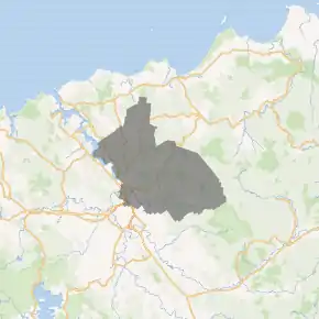
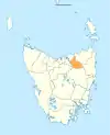
Map showing the Launceston local government area. | |||||||||||||||
| Coordinates | 41.3605°S 147.3044°E | ||||||||||||||
| Population | 67,449 (2018)[1] | ||||||||||||||
| • Density | 47.701/km2 (123.54/sq mi) | ||||||||||||||
| Established | 1 January 1853[2] | ||||||||||||||
| Area | 1,414 km2 (545.9 sq mi)[1] | ||||||||||||||
| Mayor | Albert Van Zetten | ||||||||||||||
| Council seat | Launceston | ||||||||||||||
| Region | Launceston and surrounds | ||||||||||||||
| State electorate(s) | Bass | ||||||||||||||
| Federal Division(s) | Bass | ||||||||||||||
| Website | Launceston City Council | ||||||||||||||
| |||||||||||||||
Government
The current mayor is Albert Van Zetten, who defeated Legislative Councillor Ivan Dean in the 2007 council elections. Dean's predecessor, Janie Dickenson, was, at the time of her election, the youngest female mayor in Australia. She was first elected mayor in February 2002 at the age of 27.
History and attributes
Launceston is classified as urban, regional and medium (URM) under the Australian Classification of Local Governments.[3] The population at the 2016 Census was over 65,000, making Launceston the most populous of the 29 Local Government Areas in Tasmania.
The municipality logo features the now extinct Tasmanian tiger, an indigenous marsupial that used to be prevalent in the Launceston district.
History
Launceston was first declared as a municipality in 1853 and declared a city in 1888. Its original boundaries have long since been redefined and the area now known as the City of Launceston includes parts of the former Lilydale, St Leonard's, Evandale and Westbury Municipalities.[4] In the 1890s, the municipality grew to include Galvin Town (South Launceston) and in 1906 to include the northern suburbs of Invermay, Mowbray and Trevallyn.[5] This has produced a local government area that overlaps its similarly named city, rather than either being contained by or encompassing it.
Localities
Suburbs of the city of Launceston
• Dilston • East Launceston • Invermay • Kings Meadows • Launceston • Mayfield • Mowbray • Newnham • Newstead • Norwood • Prospect • Punchbowl • Ravenswood • Rocherlea • South Launceston • St Leonards • Summerhill • Trevallyn • Waverley • West Launceston • Youngtown
Localities other than suburbs
• Bangor • Blessington • Burns Creek • Golconda • Karoola • Lalla • Lebrina • Lilydale • Lower Turners Marsh • Mount Direction • Myrtle Bank • North Lilydale • Nunamara • Patersonia • Pipers Brook • Pipers River • Prospect Vale • Relbia • Retreat • Springfield • Swan Bay • Targa • Tayene • Tunnel • Turners Marsh • Underwood • Upper Blessington • White Hills • Windermere • Wyena
See also
- List of local government areas of Tasmania
References
- "3218.0 – Regional Population Growth, Australia, 2017-18: Population Estimates by Local Government Area (ASGS 2018), 2017 to 2018". Australian Bureau of Statistics. Australian Bureau of Statistics. 27 March 2019. Retrieved 25 October 2019. Estimated resident population, 30 June 2018.
- http://www7.austlii.edu.au/cgi-bin/viewdb/au/legis/tas/num_act/aatemcitcohtatol16vn17854/
- "Local government national report 2014-2015". regional.gov.au. Australian Government. Retrieved 8 June 2018.
- "Agency Details: Launceston City Council". search.archives.tas.gov.au. Tasmanian Government. Retrieved 11 June 2018.
- State Library Service of Tasmania (1999). "Properties in Launceston - their owners and occupiers". Retrieved 22 May 2007.
External links
- Launceston City Council official website
- Local Government Association Tasmania
- Tasmanian Electoral Commission - local government