Kentish Council
Kentish Council is a local government body in Tasmania, situated in the north-west of the state, to the south and inland from Devonport. Kentish is classified as a rural local government area and has a population of 6,324,[1] the major towns of the municipality are Sheffield, Railton and Wilmot.
| Kentish Council Tasmania | |||||||||||||||
|---|---|---|---|---|---|---|---|---|---|---|---|---|---|---|---|
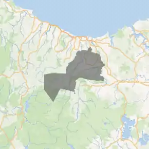
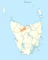
Map showing the Kentish local government area. | |||||||||||||||
| Coordinates | 41.4539°S 146.1837°E | ||||||||||||||
| Population | 6,324 (2018)[1] | ||||||||||||||
| • Density | 5.4706/km2 (14.169/sq mi) | ||||||||||||||
| Established | 1 January 1907[2] | ||||||||||||||
| Area | 1,156 km2 (446.3 sq mi)[1] | ||||||||||||||
| Mayor | Tim Wilson | ||||||||||||||
| Council seat | Sheffield | ||||||||||||||
| Region | Sheffield and Cradle Mountain area | ||||||||||||||
| State electorate(s) | Lyons | ||||||||||||||
| Federal Division(s) | Lyons | ||||||||||||||
| Website | Kentish Council | ||||||||||||||
| |||||||||||||||
History and attributes
The area was explored by the surveyor Nathaniel Kentish in 1842 who was given the task of finding a route from Deloraine through to Tasmania's north west coast. Kentish's last name has remained as the name of the area. The municipality was established on 1 January 1907.[2] Kentish is classified as rural, agricultural and large (RAL) under the Australian Classification of Local Governments.[3]
The area is a high tourism region, with the natural attractions of Cradle Mountain and Lake Barrington, and the murals within the town of Sheffield are very popular with visitors.
Suburbs[4]
| Suburb | Census population 2016 | Reason |
|---|---|---|
| Acacia Hills | 623 | |
| Lower Barrington | 238 | |
| Barrington | 197 | |
| Nook | 188 | |
| Sheffield | 1,552 | Includes Kentish |
| Lower Wilmot | 115 | |
| Wilmot | 298 | Includes Narrawa |
| Narrawa | Incl. in Wilmot | |
| Dulverton | Incl. Railton | |
| Railton | 997 | Includes Dulverton |
| Sunnyside | 104 | |
| Stoodley | 48 | |
| Beulah | 79 | |
| Lower Beulah | 55 | |
| Paradise | 112 | |
| Claude Road | 257 | |
| Kentish | Incl. in Sheffield | |
| West Kentish | 165 | |
| Gowrie Park | 32 | |
| Roland | 83 | |
| Mount Roland | 0 | |
| Lorinna | 77 | |
| Middlesex | 4 | |
| Moina | 31 | |
| Cethana | 0 | |
| Erriba | 47 | |
| Staverton | 88 | |
| Promised Land | 44 | |
| Nowhere Else | 40 | |
| Total | 5,474 | |
| 654 | Variance | |
| Local government total | 6,128 | Gazetted Kentish Local Government Area |
Missing from above list
- Cradle Mountain
- Kimberley
- Liena
- Melrose
- Merseylea
- Mersey Forest
- Paloona
- South Nietta
- South Spreyton
- Weegena
- West Coast
See also
- List of local government areas of Tasmania
References
- "3218.0 – Regional Population Growth, Australia, 2017-18: Population Estimates by Local Government Area (ASGS 2018), 2017 to 2018". Australian Bureau of Statistics. Australian Bureau of Statistics. 27 March 2019. Retrieved 25 October 2019. Estimated resident population, 30 June 2018.
- "Agency Details: Kentish Municipal Council". search.archives.tas.gov.au. Tasmanian Government. Retrieved 11 June 2018.
- "Local government national report 2014-2015". regional.gov.au. Australian Government. Retrieved 8 June 2018.
- Australian Bureau of Statistics. "2016 Census QuickStats". Retrieved 22 July 2017.
External links
- Kentish Council official website
- Local Government Association Tasmania
- Tasmanian Electoral Commission - local government