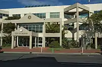
City of Burnie
Burnie City Council (or City of Burnie) is a local government body in Tasmania, located in the city and surrounds of Burnie in the north-west of the state. The Burnie local government area is classified as urban and has a population of 19,348,[1] which also encompasses Cooee, Hampshire, Natone and Ridgley.
| Burnie City Council Tasmania | |||||||||||||||
|---|---|---|---|---|---|---|---|---|---|---|---|---|---|---|---|
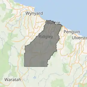
Map showing the Burnie local government area. | |||||||||||||||
| Coordinates | 41.2156°S 145.8065°E | ||||||||||||||
| Population | 19,348 (2018)[1] | ||||||||||||||
| • Density | 31.666/km2 (82.01/sq mi) | ||||||||||||||
| Established | 6 January 1908[2] | ||||||||||||||
| Area | 611 km2 (235.9 sq mi)[1] | ||||||||||||||
| Mayor | Steve Kons | ||||||||||||||
| Council seat | Burnie | ||||||||||||||
| Region | Burnie and surrounds | ||||||||||||||
| State electorate(s) | Braddon | ||||||||||||||
| Federal Division(s) | Braddon | ||||||||||||||
| Website | Burnie City Council | ||||||||||||||
| |||||||||||||||
History and attributes
The municipality was established on 6 January 1908. Originally named Emu Bay, the name was changed to Burnie in 1931 following a petition from residents to name the council based on the town it was centred on.[2][3] Burnie became a city council on 26 April 1988.[4]
The city's motto is "non nobis solum" (not for ourselves alone); for many years this was on the council seal but in 1992 a new, more colourful logo was created that did not include the motto. It did also not include the emu (which had been Burnie's unofficial animal emblem). Burnie's floral emblem is the rhododendron.
Burnie is classified as urban, regional and small (URS) under the Australian Classification of Local Governments.[5] Burnie does not include the adjacent town of Somerset that is sometimes classed as part of the Burnie metropolitan area.
Government
The Burnie City Council consists of nine councillors, who each serve a four-year term of office. Traditionally the term "alderman" was used, but was changed by a council vote on 20 November 2018.[6] The members following the 2018 election are:
| Name | Position[7] | Party affiliation | |
|---|---|---|---|
| Steve Kons | Mayor/Councillor | Independent | |
| Giovanna Simpson | Deputy Mayor/Councillor | Independent | |
| Alvwyn Boyd | Councillor | Independent | |
| Teeny Brumby | Councillor | Independent | |
| Themba Bulle | Councillor | Independent | |
| Ken Dorsey | Alderman | Independent | |
| Amina Keygan | Councillor | Independent | |
| Chris Lynch | Councillor | Independent | |
| David Pease | Councillor | Independent | |
Suburbs
The following gazetted suburbs/localities are fully or partially within the City of Burnie:[8] [9]
| Suburb | Census population 2016 | Notes |
|---|---|---|
| Acton | 1,349 | |
| Brooklyn | 553 | |
| Burnie | 596 | Central business district |
| Camdale | 72 | |
| Chasm Creek | 68 | |
| Cooee | 527 | |
| Downlands | 240 | |
| East Cam | 170 | |
| East Ridgley | 103 | |
| Emu Heights | 180 | |
| Hampshire | 51 | partial, see note below |
| Havenview | 715 | |
| Heybridge | partial, see note below | |
| Highclere | 120 | |
| Hillcrest | 1,042 | |
| Montello | 1,217 | |
| Mooreville | 303 | |
| Natone | 281 | |
| Ocean Vista | 306 | |
| Oonah | 0 | partial, see note below |
| Park Grove | 2,385 | |
| Parklands | 850 | |
| Parrawe | partial, see note below | |
| Ridgley | 604 | |
| Romaine | 1,713 | |
| Round Hill | 109 | |
| Shorewell Park | 2,008 | |
| South Burnie | 331 | |
| Stowport | 404 | |
| Tewkesbury | 76 | |
| Upper Burnie | 1,821 | |
| Upper Natone | 112 | |
| Upper Stowport | 105 | |
| West Mooreville | 114 | |
| West Ridgley | 125 | |
| Wivenhoe | 220 | |
| Total | 18870 | |
| 25 | Variance | |
| Local government total | 18895 | Gazetted Burnie Local Government Area |
Only the part of Heybridge to the west of the Blythe River is in the City of Burnie. Most of its population of 430 would be to the east in Central Coast.
Oonah mostly lies in Waratah-Wynyard, but the 2016 census recorded a population of zero in any case.
A small part of Hampshire extends into Waratah-Wynyard, but all of its population is likely to be in the City of Burnie.
Parrawe mostly lies in Waratah-Wynyard. The small area in the City of Burnie is likely to be unpopulated.
See also
- List of local government areas of Tasmania
References
- "3218.0 – Regional Population Growth, Australia, 2017-18: Population Estimates by Local Government Area (ASGS 2018), 2017 to 2018". Australian Bureau of Statistics. Australian Bureau of Statistics. 27 March 2019. Retrieved 25 October 2019. Estimated resident population, 30 June 2018.
- "Agency Details: Emu Bay Municipal Council". search.archives.tas.gov.au. Tasmanian Government. Retrieved 11 June 2018.
- "Agency Details: Burnie Municipal Council". search.archives.tas.gov.au. Tasmanian Government. Retrieved 11 June 2018.
- "Agency Details: Burnie City Council". search.archives.tas.gov.au. Tasmanian Government. Retrieved 11 June 2018.
- "Local government national report 2014-2015". regional.gov.au. Australian Government. Retrieved 8 June 2018.
- Minutes 20 November 2018 Proposal for Council to Adopt the Term Councillor (PDF), Burnie City Council, 20 November 2018, archived from the original (PDF) on 27 November 2018, retrieved 27 November 2018
- "Elected Representatives - Burnie City". burnie.net. Burnie City Council. Retrieved 13 November 2018.
- Burnie City Council (21 August 2018). "Burnie Council Map" (PDF). Archived from the original (PDF) on 10 November 2016. Retrieved 18 February 2019.
- "2016 QuickStats". Australian Bureau of Statistics.
External links
- Burnie City Council official website
- Local Government Association Tasmania
- Tasmanian Electoral Commission - local government