Central Maluku Regency
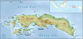
Central Maluku Regency (Indonesian: Kabupaten Maluku Tengah) is a regency of Maluku, Indonesia. The Regency covers an area of 11,595.57 km2, and had a population of 361,698 at the 2010 Census,[1] and 369,315 at the 2015 Census.[2] The principal town lies at Masohi, on Seram Island. The regency (kebupaten) is composed of the central part of the island of Seram, the Banda Islands, and the Lease Islands (Saparua, Haruku, and Nusa Laut), together with those parts of Ambon Island which are outside the City of Ambon.
Central Maluku Regency
Kabupaten Maluku Tengah | |
|---|---|
 Coat of arms | |
| Motto(s): Pamahanunusa | |
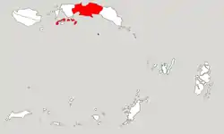 Location within Maluku | |
| Coordinates: 3°17′30″S 128°58′03″E | |
| Country | Indonesia |
| Province | Maluku |
| Capital | Masohi |
| Government | |
| • Regent | Tuasikal Abua |
| • Vice Regent | Marlatu L. Leleury |
| Area | |
| • Total | 11,595.57 km2 (4,477.07 sq mi) |
| Population (2015) | |
| • Total | 369,315 |
| • Density | 32/km2 (82/sq mi) |
| Time zone | UTC+9 (IEST) |
| Area code | (+62) 914 |
| Website | maltengkab |

This regency is the largest in area among Malukan regencies.
Administration
The regency is divided into eighteen districts (kecamatan), tabulated below with their areas (in km2) and their populations at the 2010[3] and 2015 Censuses.[4] The table also includes the number of administrative villages (desa and kelurahan) in each district and its post code.
| Name | English name | Admin. Centre | Area in km2 | Pop'n Census 2010 | Pop'n Census 2015 | Nunber of villages | Post code |
|---|---|---|---|---|---|---|---|
| Leihitu | Hila | 147.63 | 46,978 | 47,966 | 11 | 97580 | |
| Leihitu Barat | West Leihitu | Larike | 84.47 | 16,678 | 17,030 | 5 | 97581 |
| Sala Hutu | Tulehu | 151.82 | 46,703 | 47,687 | 6 | 97582 | |
| (totals on Ambon Island) | 383.92 | 110,359 | 112,683 | 22 | |||
| Pulau Haruku | Haruku Island | Pelauw | 150.00 | 24,207 | 24,717 | 11 | 97583 |
| Saparua | Kota Saparua | 79.90 | 32,475 | 16,707 | 7 | 97584 | |
| Saparua Timur | East Saparua | Tuhaha | 96.60 | (a) | 16,452 | 10 | 97585 |
| Nusa Laut | Nusa Laut Island | Ameth | 32.50 | 5,322 | 5,434 | 7 | 97518 |
| (totals on Lease Islands) | 359.00 | 62,004 | 63,310 | 35 | |||
| Amahai | Amahai | 1,619.07 | 38,932 | 39,753 | 15 | 97516 | |
| Kota Masohi | Masohi Town | Masohi | 37.30 | (b)31,480 | 32,144 | (b)5 | 97511 -97515 |
| Seram Utara | North Seram | Wahai | 7,173.46 | 39,249 | 16,350 | 20 | 97531 |
| Seram Utara Barat | Northwest Seram | Pasanea | 705.48 | 9,260 | 9,454 | 13 | 97532 |
| Seram Utara Timur Kobi | Northeast Seram Kobi | Kobi | 280.65 | (c) | 10,294 | 12 | 97533 |
| Seram Utara Timur Seti | Northeast Seram Seti | Kobisonta | 186.19 | (c) | 13,431 | 12 | 97534 |
| Tehoru | Tehoru | 405.72 | 28,191 | 18,641 | 10 | 97519 | |
| Teluk Elpaputih | Elpaputih Bay | Sahulau | 120.00 | 10,822 | 11,050 | 4 | 97517 |
| Telutih | Laimu | 128.50 | (d) | 10,143 | 10 | 97510 | |
| Teon Nila Serua | Waipia | 24.28 | 12,857 | 13,127 | 16 | 97535 | |
| (totals on Seram Island) | 10,680.65 | 170,791 | 174,387 | 117 | |||
| Banda | Banda Islands | Banda Neira | 172.00 | 18,544 | 18,934 | 18 | 97586 |
Notes: (a) 2010 population figure for Saparua Timur is included in that for Saparua.
(b) comprises the five kelurahan (with 2010 Census populations) of Ampera (5,558), Lesane (4,305), Letwaru (5,187), Namaelo (13,367) and Namasina (3,338).
(c) 2010 population figures for Seram Utara Timur Kobi and Seram Utara Timur Seti are included in that for Seram Utara.
(d) 2010 population figure for Telutih is included in that for Tehoru.
References
- Biro Pusat Statistik, Jakarta, 2011.
- Badan Pusat Statistik, Jakarta, 2019.
- Biro Pusat Statistik, Jakarta, 2011.
- Badan Pusat Statistik, Jakarta, 2019.
External links
| Wikimedia Commons has media related to Central Maluku Regency. |