South Buru Regency
South Buru Regency is a regency of Maluku, Indonesia. It is located on the island of Buru, of which it comprises the southern half. The Regency (which includes the smaller island of Ambalau to the southeast of Buru Island) covers a land area of 3,780.56 km2, and it had a population of 53,671 at the 2010 Census;[1] at the 2015 Intermediate Census this had risen to 59,212.[2] The principal town lies at Namrole.
South Buru Regency
Kabupaten Buru Selatan | |
|---|---|
 Coat of arms | |
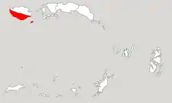 Location within Maluku | |
| Coordinates: 3°51′S 126°42′E | |
| Country | Indonesia |
| Province | Maluku |
| Capital | Namrole |
| Government | |
| • Regent | Tagop Sudarsono Soulisa |
| • Vice Regent | Buce Ayub Seleky |
| Area | |
| • Total | 3,780.56 km2 (1,459.68 sq mi) |
| Population (2015) | |
| • Total | 59,212 |
| • Density | 16/km2 (41/sq mi) |
| Time zone | UTC+9 (IEST) |
| Area code | (+62) 913 |
| Website | burselkab |

Administration
The regency is divided into five districts (kecamatan), tabulated below with their areas and their 2010 Census populations.
| Name | Area in km2 | Population Census 2010 |
|---|---|---|
| Kepala Madan | 812.4 | 9,411 |
| Leksula | 1,574.2 | 14,900 |
| Namrole | 983.5 | 10,809 |
| Waisama | 699.8 | 11,505 |
| Ambalau | 201.7 | 6,846 |
Climate
Namrole, the seat of the regency has a tropical rainforest climate (Af) moderate rainfall from October to March and heavy to very heavy rainfall from April to September. Unlike most parts of Indonesia, the southern part of Buru island experiences a rainfall maximum during the low-sun season due to local wind currents.
| Climate data for Namrole | |||||||||||||
|---|---|---|---|---|---|---|---|---|---|---|---|---|---|
| Month | Jan | Feb | Mar | Apr | May | Jun | Jul | Aug | Sep | Oct | Nov | Dec | Year |
| Average high °C (°F) | 30.7 (87.3) |
30.8 (87.4) |
30.8 (87.4) |
30.4 (86.7) |
29.8 (85.6) |
29.1 (84.4) |
28.3 (82.9) |
28.4 (83.1) |
29.6 (85.3) |
30.3 (86.5) |
31.4 (88.5) |
31.1 (88.0) |
30.1 (86.1) |
| Daily mean °C (°F) | 27.2 (81.0) |
27.3 (81.1) |
27.2 (81.0) |
27.0 (80.6) |
26.8 (80.2) |
26.3 (79.3) |
25.7 (78.3) |
25.5 (77.9) |
26.2 (79.2) |
26.5 (79.7) |
27.6 (81.7) |
27.5 (81.5) |
26.7 (80.1) |
| Average low °C (°F) | 23.8 (74.8) |
23.8 (74.8) |
23.7 (74.7) |
23.7 (74.7) |
23.8 (74.8) |
23.6 (74.5) |
23.1 (73.6) |
22.7 (72.9) |
22.8 (73.0) |
22.7 (72.9) |
23.9 (75.0) |
23.9 (75.0) |
23.5 (74.2) |
| Average rainfall mm (inches) | 142 (5.6) |
119 (4.7) |
119 (4.7) |
139 (5.5) |
239 (9.4) |
436 (17.2) |
515 (20.3) |
213 (8.4) |
157 (6.2) |
84 (3.3) |
85 (3.3) |
109 (4.3) |
2,357 (92.9) |
| Source: Climate-Data.org[3] | |||||||||||||
References
- Biro Pusat Statistik, Jakarta, 2011.
- Badan Pusat Statistik, Jakarta, 2018.
- "Climate: Namrole". Climate-Data.org. Retrieved 23 November 2020.
External links
| Wikimedia Commons has media related to South Buru Regency. |
