East Seram Regency
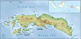
East Seram Regency (Indonesian: Kabupaten Seram Bagian Timur) is a regency of Maluku, Indonesia. It is mainly located on the island of Seram, but also includes smaller islands to the southeast comprising the Gorom and Watubela archipelagoes. The regency covers a land area of 6,429.88 km2, and had a population of 99,065 at the 2010 Census;[2] the latest official estimate was 114,677 in mid 2019.[3] The principal town lies at Bula.
East Seram Regency
Kabupaten Seram Bagian Timur | |
|---|---|
 Coat of arms | |
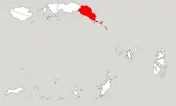 Location within Maluku | |
| Coordinates: 3.3985°S 130.3917°E | |
| Country | |
| Province | |
| Capital | Bula |
| Government | |
| • Regent | Mukti Keliobas |
| • Vice Regent | Fachri H. Alkatiri |
| Area | |
| • Total | 6,429.88 km2 (2,482.59 sq mi) |
| Population (2019)[1] | |
| • Total | 114,677 |
| • Density | 18/km2 (46/sq mi) |
| Time zone | UTC+9 (IEST) |
| Area code | (+62) 911 |
| Website | serambagiantimurkab |

Administration
At the time of the 2010 Census the regency was divided into six districts (kecamatan). The first four of these six districts were on the island of Seram; the Gorom and Watubela archipelagoes are groups of smaller islands situated to the southeast of Seram. Subsequent to 2010, nine additional districts were created by the division of the original six districts, so that the regency is now divided into fifteen districts (kecamatan), of which ten are on the island of Seram and five on the islands to its southeast. These are tabulated below with their 2010 areas and Census populations and officially estimated 2014 populations.[4]
| Name | Area in km2 | Population Census 2010 | Population Estimate mid 2014 | Population Estimate mid 2019 | No. of Villages | Post Code |
|---|---|---|---|---|---|---|
| Bula1 | 2,248.6 | 24,037 | 15,812 | 16,537 | 10 | 97521 |
| Bula Barat (West Bula) | 1 | 1 | 6,516 | 6,795 | 13 | 97522 |
| Teluk Waru (Waru Bay) | 1 | 1 | 4,108 | 4,493 | 11 | 97524 |
| Werinama2 | 1,823.8 | 9,752 | 5,324 | 5,830 | 10 | 97525 |
| Siwalalat | 2 | 2 | 4,986 | 5,459 | 12 | 97523 |
| Tutuk Tolu | 435.2 | 4,722 | 4,868 | 5,466 | 11 | 97594 |
| Seram Timur3 (East Seram) | 1,136.7 | 24,018 | 10,951 | 11,857 | 16 | 97592 |
| Kilmury | 3 | 3 | 4,511 | 4,931 | 14 | 97591 |
| Kian Darat | 3 | 3 | 5,034 | 5,501 | 10 | 97590 |
| Siritaun Wida Timur (East Siritaun Wida ) | 3 | 3 | 5,049 | 5,514 | 10 | 97598 |
| Pulau Gorom4 (Gorom Island) | 131.4 | 25,249 | 20,287 | 20,752 | 24 | 97593 |
| Gorom Timur (East Gorom) | 4 | 4 | 7,124 | 8,618 | 23 | 97596 |
| Pulau Panjang (Panjang Island) | 20.6 | 1,913 | 2,036 | 2,214 | 6 | 97599 |
| Wakate5 | 43.1 | 9,251 | 7,301 | 7,750 | 18 | 97595 |
| Teor (Teor Island) | 23.3 | 2,556 | 2,791 | 2,959 | 10 | 97597 |
Notes:
- 1 The areas and 2010 Census populations of Bula Barat and Teluk Waru districts are included with the figures for Bula district, from which they were cut out.
- 2 The area and 2010 Census population of Siwalalat district are included with the figures for Werinama district, from which it was cut out.
- 3 The areas and 2010 Census populations of Kilmury, Kian Dalat and Siritaun Wida Timur districts are included with the figures for Seram Timur district, from which they were cut out.
- 4 The area and 2010 Census population of Gorom Timur district are included with the figures for Pulau Gorom district, from which it and Pulau Panjang district were cut out.
- 5 The area and 2010 Census population of Wakate district exclude the figures for Teor district, which was cut out of Wakate.
References
- Badan Pusat Statistik, Jakarta, 2020.
- Biro Pusat Statistik, Jakarta, 2011.
- Badan Pusat Statistik, Jakarta, 2020.
- Badan Pusat Statistik, Jakarta, 2019.