Châtres, Seine-et-Marne
Châtres is a commune in the Seine-et-Marne department in the Île-de-France region in north-central France.
Châtres | |
|---|---|
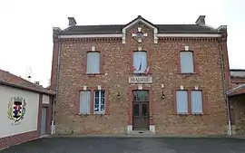 The town hall in Châtres | |
.svg.png.webp) Coat of arms | |
Location of Châtres 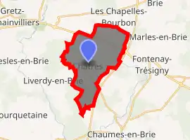
| |
 Châtres  Châtres | |
| Coordinates: 48°42′38″N 2°48′35″E | |
| Country | France |
| Region | Île-de-France |
| Department | Seine-et-Marne |
| Arrondissement | Provins |
| Canton | Fontenay-Trésigny |
| Intercommunality | CC Val Briard |
| Government | |
| • Mayor (2008–2014) | Michel Rollin |
| Area 1 | 15.13 km2 (5.84 sq mi) |
| Population (2017-01-01)[1] | 678 |
| • Density | 45/km2 (120/sq mi) |
| Time zone | UTC+01:00 (CET) |
| • Summer (DST) | UTC+02:00 (CEST) |
| INSEE/Postal code | 77104 /77610 |
| Elevation | 89–117 m (292–384 ft) |
| 1 French Land Register data, which excludes lakes, ponds, glaciers > 1 km2 (0.386 sq mi or 247 acres) and river estuaries. | |
History
Châtres began as a Roman camp. Its name, formerly Chastres, is derived from Latin castrum.
Châtres is documented as the place where Saint Corbinian was born circa 670 and where he maintained a hermitage for fourteen years.
Demographics
The inhabitants of Châtres are called Châtriots. As of 2017, its population is 678.
Places of interest
Place of interest include the Château de Boulayes and its park.
Agriculture
The area produces cereal grain.
References
- "Populations légales 2017". INSEE. Retrieved 6 January 2020.
- (in French) Commune de Châtres
External links
| Wikimedia Commons has media related to Châtres (Seine-et-Marne). |
- (in French) Old postcards of Châtres
- (in French) Find Châtres on the map of Seine-et-Marne
- (in English) 1999 Land Use, from IAURIF (Institute for Urban Planning and Development of the Paris-Île-de-France region)
- Base Mérimée: Search for heritage in the commune, Ministère français de la Culture. (in French)
This article is issued from Wikipedia. The text is licensed under Creative Commons - Attribution - Sharealike. Additional terms may apply for the media files.