Ozoir-la-Ferrière
Ozoir-la-Ferrière (French pronunciation: [ɔzwaʁ la fɛʁjɛʁ]) is a commune in the Seine-et-Marne department in the Île-de-France region in north-central France. It is located in the urban area of Paris 25.6 km (15.9 mi) east-southeast from the center.
Ozoir-la-Ferrière | |
|---|---|
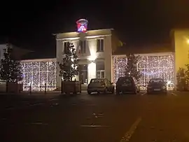 The town hall of Ozoir-la-Ferrière | |
.svg.png.webp) Coat of arms | |
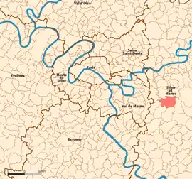 Location (in red) within Paris inner and outer suburbs | |
Location of Ozoir-la-Ferrière 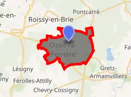
| |
 Ozoir-la-Ferrière Location (in red) within Paris inner and outer suburbs  Ozoir-la-Ferrière Ozoir-la-Ferrière (Île-de-France (region)) | |
| Coordinates: 48°46′41″N 2°40′48″E | |
| Country | France |
| Region | Île-de-France |
| Department | Seine-et-Marne |
| Arrondissement | Torcy |
| Canton | Ozoir-la-Ferrière |
| Intercommunality | Les Portes Briardes Entre Ville et Forêts |
| Government | |
| • Mayor (2020–2026) | Jean-François Oneto[1] |
| Area 1 | 15.58 km2 (6.02 sq mi) |
| Population (2017-01-01)[2] | 20,331 |
| • Density | 1,300/km2 (3,400/sq mi) |
| Time zone | UTC+01:00 (CET) |
| • Summer (DST) | UTC+02:00 (CEST) |
| INSEE/Postal code | 77350 /77330 |
| Elevation | 94–122 m (308–400 ft) |
| 1 French Land Register data, which excludes lakes, ponds, glaciers > 1 km2 (0.386 sq mi or 247 acres) and river estuaries. | |
Demographics
Inhabitants are called Ozoiriens or Ozophoriciens.
History
During the French Revolution, Ozoir-la-Ferrière was temporarily renamed Ozoir-la-Raison, meaning "Ozoir the Reason".
Transportation
Ozoir-la-Ferrière is served by Ozoir-la-Ferrière station on Paris RER line ![]() .
.
Twin cities
Ozoir-la-Ferrière is twinned with the town of Swords, the county town of Fingal, in Dublin, eastern Ireland.
References
- "Répertoire national des élus: les maires". data.gouv.fr, Plateforme ouverte des données publiques françaises (in French). 2 December 2020. Retrieved 11 December 2020.
- "Populations légales 2017". INSEE. Retrieved 6 January 2020.
External links
| Wikimedia Commons has media related to Ozoir-la-Ferrière. |
- Official website (in French)
- 1999 Land Use, from IAURIF (Institute for Urban Planning and Development of the Paris-Île-de-France région) (in English)
- Base Mérimée: Search for heritage in the commune, Ministère français de la Culture. (in French)
| Authority control |
|---|
This article is issued from Wikipedia. The text is licensed under Creative Commons - Attribution - Sharealike. Additional terms may apply for the media files.