La Chapelle-Rablais
La Chapelle-Rablais is a commune in the Seine-et-Marne department in the Île-de-France region in north-central France.
La Chapelle-Rablais | |
|---|---|
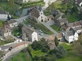 An aerial view of La Chapelle-Rablais | |
.svg.png.webp) Coat of arms | |
Location of La Chapelle-Rablais 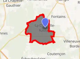
| |
 La Chapelle-Rablais  La Chapelle-Rablais | |
| Coordinates: 48°30′43″N 2°58′21″E | |
| Country | France |
| Region | Île-de-France |
| Department | Seine-et-Marne |
| Arrondissement | Provins |
| Canton | Nangis |
| Intercommunality | CC Brie Nangissienne |
| Government | |
| • Mayor (2008–2014) | Daniel Deswarte |
| Area 1 | 15.44 km2 (5.96 sq mi) |
| Population (2017-01-01)[1] | 946 |
| • Density | 61/km2 (160/sq mi) |
| Time zone | UTC+01:00 (CET) |
| • Summer (DST) | UTC+02:00 (CEST) |
| INSEE/Postal code | 77089 /77370 |
| Elevation | 104–136 m (341–446 ft) |
| 1 French Land Register data, which excludes lakes, ponds, glaciers > 1 km2 (0.386 sq mi or 247 acres) and river estuaries. | |
Its inhabitants are called the Capello-Rablaisiens.
Geography
Location
La Chapelle-Rablais is located in the heart of Brie, 8 km (4.97 miles) southwest of Nangis.
Bordering municipalities
| Fontenailles
(5.4 km ) |
Nangis
(7.4 km ) |
Fontains
(4.6 km ) |
| Villeneuve-les-Bordes
(7.5 km ) | ||
| Échouboulains
(4.8 km ) |
Laval-en-Brie
(10.1 km ) |
Coutençon
(5.6 km ) |
Geology and relief
The town is classified in seismicity zone 1, corresponding to a very low seismicity.[2]
Hydrography
The municipality's hydrographic system consists of nine referenced rivers:
- the Almont river (or ru d'Ancœur or ru de Courtenain), which is 42.15 km long[3] and a tributary of the Seine, as well as;
- the Courtenain arm, 0.53 km ;
- the ditch 01 of the Grand Buisson du Mée, 1.35 km, and;
- Mauny stream 01, 1.16 km, tributaries of the Almont;
- the ditch 01 of the Bois de Putemuse, 1.04 km , tributary of the stream 01 of Mauny;
- the Ru de Villefermoy, 8.19 km ;
- the Ru des Prés des Vallées, 3.97 km , and;
- the ditch 02 of the Bois de la Chapelle, 3.61 km, and;
- the ditch 01 of the Forêt Domaniale de Villefermoy, 2.95 km, which merges with the ru de Villefermoy.
The overall linear length of watercourses in the municipality is 11.01 km (6.84 mi).[4]
Communication and Transport Routes
The closest station to the town is the Nangis station on the Paris-Est - Provins line of the Transilien Paris-Est network. This line is now served by new Bombardier B 82500 dual-energy trains .
Urbanism
Localities, deviations and districts
The town has 47 administrative localities listed including Les Montils, and Les Moyeux .
Land use
In 2018,[5] the territory of the municipality was 53.4% being forest land, 40.3% arable land, 4.6% of urbanized areas and 1.7% of artificial green spaces that were of non-agricultural purpose[6][4]
References
- "Populations légales 2017". INSEE. Retrieved 6 January 2020.
- "La Chapelle-Rablais — Wikipédia". fr.wikipedia.org (in French). Retrieved 2020-07-20.
- "L'almont [F44-0400] - Cours d'eau". www.sandre.eaufrance.fr (in French). Retrieved 2020-07-20.
- "Fiche commune La Chapelle-Rablais". SIGES Seine-Normandie. Retrieved 14 December 2020.
- "CORINE Land Cover | Données et études statistiques". www.statistiques.developpement-durable.gouv.fr. Retrieved 2020-07-20.
- "Occupation du sol simplifiée 2017 La Chapelle-Rablais" (PDF). IAU ÎdF. Retrieved 14 December 2020.
External links
| Wikimedia Commons has media related to La Chapelle-Rablais. |
- 1999 Land Use, from IAURIF (Institute for Urban Planning and Development of the Paris-Île-de-France région) (in English)
- Base Mérimée: Search for heritage in the commune, Ministère français de la Culture. (in French)
| Authority control |
|
|---|