Chalan Pago-Ordot, Guam
Chalan Pago-Ordot (Chamorro: Chalan Pågu-Otdot) is a municipality in the United States territory of Guam, containing the villages of Chalan-Pago and Ordot. It is located in the eastern-central part of the island and is part of the Kattan (Eastern) District. The village's population has increased slightly following the island's 2000 census.[3]
Chalan Pago-Ordot Chalan Pågu-Otdot | |
|---|---|
 Flag | |
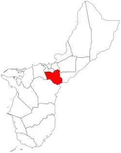 Location of Chalan Pago-Ordot within the Territory of Guam. | |
| Country | United States |
| Territory | Guam |
| Government | |
| • Mayor | Jessy "Jess" Cruz Gogue (D) |
| Population (2010)[1] | |
| • Total | 6,822 |
| • Ethnic groups | (as of 2,000[2]) 90% Chamorro Micronesian |
| Time zone | UTC+10 (ChST) |
| Village Flower | Pink Catharanthus roseus / Chichirica Hibiscus tiliaceus / Pago |
| Historical population | |||
|---|---|---|---|
| Census | Pop. | %± | |
| 1960 | 1,835 | — | |
| 1970 | 2,931 | 59.7% | |
| 1980 | 3,120 | 6.4% | |
| 1990 | 4,451 | 42.7% | |
| 2000 | 5,923 | 33.1% | |
| 2010 | 6,822 | 15.2% | |
| Source:[1] | |||
Etymology
Pågu is the Chamorro word for the wild tree Hibiscus tiliaceus,[4] while "chalan"' means "road". The name Chalan Pago is named after the path from Hagåtña to the Spanish village at Pago Bay. Ordot comes from the word otdot, or ant.
In World War II, the Japanese used the area as a supply depot during their occupation of the island. Ordot is also the site of the controversial Ordot Landfill, first constructed by the U.S. Navy, but now full and in violation of United States Environmental Protection Agency (EPA) regulations.[5]
Demographics
The U.S. Census Bureau has the municipality in multiple census-designated places: Chalan-Pago,[6] and Ordot.[7]
Education
The Guam Public School System serves the island.
Ordot/Chalan Pago Elementary School and Agueda Johnston Middle School are located in Chalan-Pago-Ordot. Johnston is located in Ordot; originally it was named George Washington Junior High School.[8] George Washington High School in Mangilao serves the village as a secondary school.[9]
Father Dueñas Memorial School is in the area.[10]
St. Thomas Aquinas Catholic High School was open 2008-2015.
Government
| Commissioner of Chalan Pago-Ordot | ||
| Name | Term begin | Term end |
|---|---|---|
| Francisco L.G. Valenzuela | 1956 | 1964 |
| Thomas B. Anderson | 1964 | 1969 |
| Francisco C. Carbullido | 1969 | January 1, 1973 |
| Mayor of Chalan Pago-Ordot | |||
| Name | Party | Term begin | Term end |
|---|---|---|---|
| Francisco C. Carbullido | Republican | January 1, 1973 | January 3, 1977 |
| Vicente S. San Nicolas | Democratic | January 3, 1977 | January 6, 1997 |
| Rossanna D. San Miguel | January 6, 1997 | January 1, 2001 | |
| Vicente I. Aguon | January 1, 2001 | January 3, 2005 | |
| Pedro I. Borja | Republican | January 3, 2005 | January 5, 2009 |
| Jessy C. Gogue | Democratic | January 5, 2009 | present |
See also
Gallery
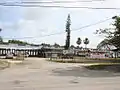 Agueda Johnston Middle School
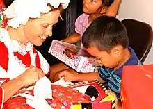 Lt. Lisa Braun of U.S. Naval Hospital Guam, hands a toy to a Chalan Pago-Ordot child displaced following Super Typhoon Pongsona during a Christmas holiday event held for the children
References
| Wikimedia Commons has media related to Chalan Pago-Ordot, Guam. |
- "2010 Guam Statistical Yearbook" (PDF). Archived from the original (PDF) on 2014-07-23. (4.3 MB), (rev. 2011)
- Census.gov
- Hart, Therese (August 26, 2011). "Guam Population slightly up, latest census says". Marianas Variety. Archived from the original on January 26, 2016. Retrieved August 27, 2011.
- Comfsm.fm
- Clynt Ridgell (December 2, 2006). "Senators comment on Ordot dump's environmental impacts". Kuam.
- "2010 CENSUS - CENSUS BLOCK MAP: Chalan Pago CDP, GU" (PDF). U.S. Census Bureau. Retrieved 2020-10-09. - See "Chalan-Pago-Ordot muny"
- "2010 CENSUS - CENSUS BLOCK MAP (INDEX): Ordot CDP, GU" (PDF). U.S. Census Bureau. Retrieved 2020-10-09. - Pages 1 and 2
- "Welcome to Agueda I. Johnston Middle School." Agueda I. Johnston Middle School. Retrieved on October 20, 2010.
- "Guam's Public High Schools Archived 2006-05-19 at the Wayback Machine." Guam Public School System. Accessed September 8, 2008.
- "Home". Father Dueñas Memorial School. Retrieved 2020-10-09.
119 Dueñas Lane Chalan Pago, Guam 96910
External links
- Ordot map from PDN
- Rogers, Robert F (1995). Destiny's Landfall: A History of Guam: University of Hawai'i Press. ISBN 0-8248-1678-1
Hagåtña (capital) | |
| Topics | |
| Islands | |
| Villages | |
| Peaks |
|
| Healthcare | |