Piti, Guam
Piti is a village located on the western shore of the United States territory of Guam. It contains the commercial port of Guam at Apra Harbor as well as several of the island's largest power plants. NAVFAC Marianas is located there.
Piti | |
|---|---|
 Flag | |
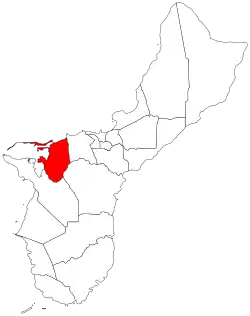 Location of Piti within the Territory of Guam | |
| Country | United States |
| Territory | Guam |
| Government | |
| • Mayor | Jesse L.G. Alig (R) |
| Population (2010)[1] | |
| • Total | 1,454 |
| • Ethnic groups | Chamorro |
| Time zone | UTC+10 (ChST) |
| Historical population | |||
|---|---|---|---|
| Census | Pop. | %± | |
| 1960 | 1,467 | — | |
| 1970 | 1,284 | −12.5% | |
| 1980 | 2,866 | 123.2% | |
| 1990 | 1,827 | −36.3% | |
| 2000 | 1,666 | −8.8% | |
| 2010 | 1,454 | −12.7% | |
| Source:[1] | |||
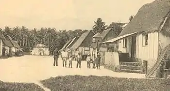
Village of Piti, 1900
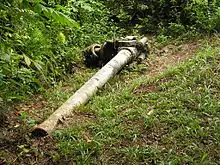
Piti Guns: WWII Japanese coastal defense guns still in Piti
Demographics
The U.S. Census Bureau counts the following census-designated places in Piti: Piti,[2] and Nimitz Hill.[3]
Education
Guam Public School System serves the island.
Jose Rios Middle School is in Piti. Southern High School in Santa Rita serves the village.[4]
Notable residents
- Vice Speaker Benjamin J.F. Cruz
- Soledad Ofalla
Mayor of Piti
Commissioner
- Manuel S. Santos (1933–1938)
- Juan B. Quenga Cruz (1938–1941)
- Gaily R. Kaminga (1952–1957)
- Vicente A. Limtiaco (1957–1973)
Mayor
- David B. Salas (1973–1981)
- Nieves F. Sablan (1981–1985)
- Bert S. Hedley (1985–1989)
- Isabel S. Haggard (1989–2005)
- Vicente "Ben" D. Gumataotao (2005–2017)
- Jesse L.G. Alig (2017–present)
References
- "2010 Guam Statistical Yearbook" (PDF). Archived from the original (PDF) on 2014-07-23. (4.3 MB), (rev. 2011)
- "2010 CENSUS - CENSUS BLOCK MAP: Piti CDP, GU" (PDF). U.S. Census Bureau. Retrieved 2020-10-09. - See "Piti muny"
- "2010 CENSUS - CENSUS BLOCK MAP: Nimitz Hill CDP, GU" (PDF). U.S. Census Bureau. Retrieved 2020-10-09. - See "Piti muny"
- "Guam's Public High Schools." Guam Public School System. Accessed September 8, 2008.
Hagåtña (capital) | |
| Topics | |
| Islands | |
| Villages | |
| Peaks |
|
| Healthcare | |
This article is issued from Wikipedia. The text is licensed under Creative Commons - Attribution - Sharealike. Additional terms may apply for the media files.