Chama, New Mexico
Chama is a village in Rio Arriba County, New Mexico, United States. The population was 1,022 at the 2010 census. The village is located in the Rocky Mountains about 7 miles (11 km) south of the Colorado-New Mexico border.
Chama, New Mexico | |
|---|---|
(NRCS_Photo_Gallery).tif.png.webp) A ranch near Chama | |
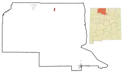 Location of Chama, New Mexico | |
 Chama, New Mexico Location in the United States | |
| Coordinates: 36°53′41″N 106°35′4″W | |
| Country | United States |
| State | New Mexico |
| County | Rio Arriba |
| Government | |
| • Mayor | Mr. Billy Elbrock |
| Area | |
| • Total | 2.62 sq mi (6.78 km2) |
| • Land | 2.59 sq mi (6.70 km2) |
| • Water | 0.03 sq mi (0.08 km2) |
| Elevation | 7,871 ft (2,399 m) |
| Population (2010) | |
| • Total | 1,022 |
| • Estimate (2019)[2] | 992 |
| • Density | 383.46/sq mi (148.04/km2) |
| Time zone | UTC-7 (Mountain (MST)) |
| • Summer (DST) | UTC-6 (MDT) |
| ZIP code | 87520 |
| Area code(s) | 575 |
| FIPS code | 35-13970 |
| GNIS feature ID | 0902207 |
| Website | http://chamavillage.com/ |
Geography
Chama is located at 36°53′41″N 106°35′4″W (36.894777, -106.584406),[3] on the Rio Chama, 6.5 miles (10 km) south of the Colorado border. According to the United States Census Bureau, the village has a total area of 2.6 square miles (6.7 km2), all of it land.
History
Chama is the western terminus of the Cumbres and Toltec Scenic Railroad, a steam-driven, narrow gauge heritage railway which carries visitors to and from Osier, Colorado, and Antonito, Colorado, during the summer months. It is the remaining 64 mile portion of the Denver & Rio Grande Railroad's San Juan Extension built in the 1880s between Alamosa, Colorado, and Durango, Colorado. The route was abandoned in the late 1960s and the tracks from Chama westward to Durango were torn up soon afterwards.
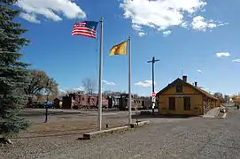 The Chama train depot
 Two DRGW locomotives waiting to be serviced at the Chama engine house, 1967.
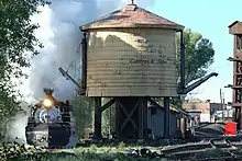 Cumbres & Toltec train in downtown Chama.
(NRCS_Photo_Gallery).jpg.webp) Northwest Field Team Leader Norm Vigil (red) and Soil Conservationist Jill Jensen (blue) provide grazing recommendations for a ranch that specializes in raising elk for hunting. Chama, New Mexico; 2011.
Northwest Field Team Leader Norm Vigil (red) and Soil Conservationist Jill Jensen (blue) provide grazing recommendations for a ranch that specializes in raising elk for hunting. Chama, New Mexico; 2011.
Demographics
| Historical population | |||
|---|---|---|---|
| Census | Pop. | %± | |
| 1970 | 899 | — | |
| 1980 | 1,090 | 21.2% | |
| 1990 | 1,048 | −3.9% | |
| 2000 | 1,199 | 14.4% | |
| 2010 | 1,022 | −14.8% | |
| 2019 (est.) | 992 | [2] | −2.9% |
| U.S. Decennial Census[4] | |||
At the 2000 census,[5] there were 1,199 people, 467 households and 312 families residing in the village. The population density was 467.9 per square mile (180.8/km2). There were 601 housing units at an average density of 234.5 per square mile (90.6/km2). The racial makeup of the village was 67.56% White, 1.58% African American, 2.67% Native American, 0.08% Asian, 25.10% from other races, and 3.00% from two or more races. Hispanic or Latino of any race were 71.23% of the population.
There were 467 households, of which 30.8% had children under the age of 18 living with them, 49.5% were married couples living together, 12.0% had a female householder with no husband present, and 33.0% were non-families. 26.3% of all households were made up of individuals, and 8.8% had someone living alone who was 65 years of age or older. The average household size was 2.57 and the average family size was 3.13.
26.6% of the population were under the age of 18, 6.7% from 18 to 24, 26.3% from 25 to 44, 28.2% from 45 to 64, and 12.3% who were 65 years of age or older. The median age was 38 years. For every 100 females, there were 95.9 males. For every 100 females age 18 and over, there were 90.1 males.
The median household income was $30,513, and the median family income was $31,983. Males had a median income of $27,167 compared with $20,054 for females. The per capita income for the village was $16,670. About 11.9% of families and 17.9% of the population were below the poverty line, including 28.6% of those under age 18 and 13.7% of those age 65 or over.
Pop culture
Chama has been featured in numerous films, including The Good Guys and the Bad Guys (1969) The Cowboys (1972), Bite the Bullett (1975), The Ballad of Gregorio Cortez (1982), Butch and Sundance: The Early Days (1989), Indiana Jones and the Last Crusade (1989), Wyatt Earp (1994), Wild Wild West (1999), All the Pretty Horses, (2000), Appaloosa (2008), A Million Ways to Die in the West (2014), Godless (2016), and Hostiles (2017).[6][7]
An episode of Anthony Bourdain: No Reservations was filmed around the Rio Chama.[8] A 2014 episode of the Discovery Channel miniseries Klondike was also filmed around Chama.[9]
Climate
This climatic region is typified by large seasonal temperature differences, with short, cool-to-warm summers and long, cold (sometimes severely cold) winters. According to the Köppen Climate Classification system, Chama has a subarctic continental climate, abbreviated "Dfb" on climate maps.[10]
| Climate data for Chama, New Mexico | |||||||||||||
|---|---|---|---|---|---|---|---|---|---|---|---|---|---|
| Month | Jan | Feb | Mar | Apr | May | Jun | Jul | Aug | Sep | Oct | Nov | Dec | Year |
| Record high °F (°C) | 57 (14) |
61 (16) |
69 (21) |
77 (25) |
89 (32) |
95 (35) |
95 (35) |
103 (39) |
90 (32) |
80 (27) |
72 (22) |
60 (16) |
103 (39) |
| Average high °F (°C) | 37 (3) |
42 (6) |
48 (9) |
57 (14) |
68 (20) |
76 (24) |
81 (27) |
78 (26) |
72 (22) |
61 (16) |
46 (8) |
38 (3) |
59 (15) |
| Average low °F (°C) | 5 (−15) |
10 (−12) |
17 (−8) |
23 (−5) |
31 (−1) |
37 (3) |
44 (7) |
44 (7) |
37 (3) |
27 (−3) |
16 (−9) |
8 (−13) |
25 (−4) |
| Record low °F (°C) | −30 (−34) |
−30 (−34) |
−19 (−28) |
−7 (−22) |
7 (−14) |
18 (−8) |
28 (−2) |
30 (−1) |
16 (−9) |
−2 (−19) |
−17 (−27) |
−30 (−34) |
−30 (−34) |
| Average precipitation inches (mm) | 1.98 (50) |
1.82 (46) |
2.20 (56) |
1.50 (38) |
1.45 (37) |
1.11 (28) |
2.14 (54) |
2.89 (73) |
2.10 (53) |
2.12 (54) |
1.98 (50) |
1.67 (42) |
22.96 (581) |
| Average snowfall inches (cm) | 27.8 (71) |
19.9 (51) |
18 (46) |
5.2 (13) |
1.2 (3.0) |
trace | 0 (0) |
0 (0) |
trace | 3.5 (8.9) |
11.9 (30) |
20.9 (53) |
108.4 (275) |
| Source 1: [11] | |||||||||||||
| Source 2: [12] | |||||||||||||
References
- "2019 U.S. Gazetteer Files". United States Census Bureau. Retrieved July 27, 2020.
- "Population and Housing Unit Estimates". United States Census Bureau. May 24, 2020. Retrieved May 27, 2020.
- "US Gazetteer files: 2010, 2000, and 1990". United States Census Bureau. 2011-02-12. Retrieved 2011-04-23.
- "Census of Population and Housing". Census.gov. Retrieved June 4, 2015.
- "U.S. Census website". United States Census Bureau. Retrieved 2008-01-31.
- Gaberscek, Carlo and Kenny Stier (2014). In Search of Western Movie Sites. Lulu Press, Inc. Page 107. ISBN 9781312625020.
- "Movie History". Cumbres & Toltec Scenic Railroad. Retrieved 2021-01-10.
- "US Files - Volume 1". Travel Channel. Retrieved 2021-01-10.
- "Filming Location Matching "Chama, New Mexico, USA" (Sorted by Popularity Ascending)". IMDb. Retrieved 2021-01-10.
- Climate Summary for Chama, New Mexico
- "Historic Averages for Chama, New Mexico". Retrieved 2017-07-04.
- "Weatherbase.com". Weatherbase. 2013. Retrieved on October 3, 2013.
External links
| Wikivoyage has a travel guide for Chama. |
Municipalities and communities of Rio Arriba County, New Mexico, United States | ||
|---|---|---|
| City | 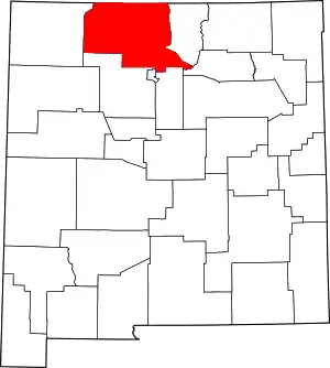 Map of New Mexico highlighting Rio Arriba County | |
| Village | ||
| CDPs |
| |
| Other unincorporated communities | ||
| Ghost towns and former settlements | ||
| Indian reservations | ||
| Footnotes | ‡This populated place also has portions in an adjacent county or counties | |
| ||