Durango, Colorado
The City of Durango is the Home Rule Municipality that is the county seat and the most populous municipality of La Plata County, Colorado, United States. It is home to Fort Lewis College. The United States Census Bureau reported a population of 16,887 in the 2010 census.[10]
Durango, Colorado | |
|---|---|
Home Rule Municipality[1] | |
| City of Durango[1] | |
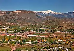 Durango as seen from Rim Drive. | |
| Motto(s): "Open Spaces and Familiar Faces" | |
 Location of the City of Durango in La Plata County, Colorado. | |
 Durango Location of the City of Durango in the United States. | |
| Coordinates: 37°16′24″N 107°52′18″W[2] | |
| Country | |
| State | |
| County | La Plata County[3] |
| City | Durango[1] |
| Founded | 1880 |
| Incorporated | April 27, 1881[4] |
| Government | |
| • Type | Home Rule Municipality[1] |
| • Mayor | Dean Brookie[5] |
| • Mayor Pro Tempore | Kim Baxter[5] |
| • City Manager | Jose Madrigal[6] |
| • City Council | Barbara Noseworthy Chris Bettin |
| Area | |
| • Total | 17.09 sq mi (44.26 km2) |
| • Land | 14.69 sq mi (38.06 km2) |
| • Water | 2.40 sq mi (6.20 km2) |
| Elevation | 6,512 ft (1,988 m) |
| Population (2010) | |
| • Total | 16,887 |
| • Estimate (2019)[8] | 18,973 |
| • Density | 1,291.30/sq mi (498.56/km2) |
| • Demonym | Durangoan Durangotan (informal) Durangatang (informal) |
| Time zone | UTC−7 (MST) |
| • Summer (DST) | UTC−6 (MDT) |
| ZIP codes[9] | 81301-81303 |
| Area code(s) | 970 |
| FIPS code | 08-22035 |
| GNIS feature ID | 0202983 |
| Website | City of Durango |
History
The town was organized in September 1880 to serve the San Juan mining district. The Denver and Rio Grande Railroad (D&RG) chose the site on the Animas River for its depot following a brief and most likely perfunctory negotiation with Animas City, two miles to the north.[11] The city was named by ex-Colorado Governor Alexander C. Hunt after Durango, Mexico, based on his favorable impression of that city resulting from a scouting trip undertaken on behalf of William J. Palmer, the head of the D&RG.
Area archaeological sites on the State and National historical registers include:
- Mesa Verde National Park, a World Heritage site
- Chimney Rock National Monument, the most northeastern known outpost of the Ancestral Puebloans
- Durango Rock Shelters Archeology Site, a Basketmaker and Pueblo culture
- Spring Creek Archeological District, a Basketmaker and Pueblo site
- Talus Village, a Basketmaker site
Geography
Durango is located at 37°16′N 107°52′W at an elevation of 6,512 ft (1,988 m). According to the United States Census Bureau, the city has a total area of 6.8 square miles (18 km2).
Climate
According to the Köppen climate classification system, Durango has either a warm-summer Mediterranean climate (Csb) or a humid continental climate (Dsb) depending on which variant of the system is used. The average annual precipitation is 19.33 in (491 mm).[12] Its hardiness zone is 5b.[13]
| Durango (1971-2000 normals) | ||||||||||||||||||||||||||||||||||||||||||||||||||||||||||||
|---|---|---|---|---|---|---|---|---|---|---|---|---|---|---|---|---|---|---|---|---|---|---|---|---|---|---|---|---|---|---|---|---|---|---|---|---|---|---|---|---|---|---|---|---|---|---|---|---|---|---|---|---|---|---|---|---|---|---|---|---|
| Climate chart (explanation) | ||||||||||||||||||||||||||||||||||||||||||||||||||||||||||||
| ||||||||||||||||||||||||||||||||||||||||||||||||||||||||||||
| ||||||||||||||||||||||||||||||||||||||||||||||||||||||||||||
| Climate data for Durango, Colorado, 1991–2015 normals, extremes 1894–present | |||||||||||||
|---|---|---|---|---|---|---|---|---|---|---|---|---|---|
| Month | Jan | Feb | Mar | Apr | May | Jun | Jul | Aug | Sep | Oct | Nov | Dec | Year |
| Record high °F (°C) | 65 (18) |
71 (22) |
78 (26) |
84 (29) |
98 (37) |
98 (37) |
102 (39) |
99 (37) |
96 (36) |
87 (31) |
74 (23) |
64 (18) |
102 (39) |
| Average high °F (°C) | 40.9 (4.9) |
45.8 (7.7) |
54.9 (12.7) |
62.7 (17.1) |
72.2 (22.3) |
81.5 (27.5) |
86.0 (30.0) |
83.6 (28.7) |
76.4 (24.7) |
65.0 (18.3) |
50.6 (10.3) |
40.9 (4.9) |
63.4 (17.4) |
| Average low °F (°C) | 14.5 (−9.7) |
19.4 (−7.0) |
25.8 (−3.4) |
31.2 (−0.4) |
39.3 (4.1) |
47.1 (8.4) |
54.5 (12.5) |
53.1 (11.7) |
45.4 (7.4) |
34.6 (1.4) |
23.2 (−4.9) |
15.3 (−9.3) |
33.6 (0.9) |
| Record low °F (°C) | −30 (−34) |
−27 (−33) |
−9 (−23) |
0 (−18) |
15 (−9) |
16 (−9) |
33 (1) |
31 (−1) |
20 (−7) |
5 (−15) |
−14 (−26) |
−21 (−29) |
−30 (−34) |
| Average precipitation inches (mm) | 2.30 (58) |
1.79 (45) |
1.42 (36) |
1.53 (39) |
1.16 (29) |
0.57 (14) |
1.77 (45) |
2.81 (71) |
2.19 (56) |
2.02 (51) |
1.64 (42) |
1.75 (44) |
20.95 (530) |
| Average snowfall inches (cm) | 19.9 (51) |
14.9 (38) |
6.0 (15) |
3.7 (9.4) |
0.2 (0.51) |
0.0 (0.0) |
0.0 (0.0) |
0.0 (0.0) |
0.0 (0.0) |
1.1 (2.8) |
5.7 (14) |
13.2 (34) |
64.7 (164.71) |
| Source: [14] | |||||||||||||
Demographics
| Historical population | |||
|---|---|---|---|
| Census | Pop. | %± | |
| 1890 | 2,726 | — | |
| 1900 | 3,317 | 21.7% | |
| 1910 | 4,686 | 41.3% | |
| 1920 | 4,116 | −12.2% | |
| 1930 | 5,400 | 31.2% | |
| 1940 | 5,887 | 9.0% | |
| 1950 | 7,459 | 26.7% | |
| 1960 | 10,530 | 41.2% | |
| 1970 | 10,333 | −1.9% | |
| 1980 | 11,649 | 12.7% | |
| 1990 | 12,430 | 6.7% | |
| 2000 | 13,922 | 12.0% | |
| 2010 | 16,887 | 21.3% | |
| 2019 (est.) | 18,973 | [8] | 12.4% |
| U.S. Decennial Census[15] | |||
As of the 2000 census,[16] there were 13,922 people, 5,492 households, and 2,603 families residing in the city. The population density was 2,052.4 people per square mile (792.8/km2). There were 5,819 housing units at an average density of 857.8 per square mile (331.4/km2). The racial makeup of the city was 86.84% White, 0.5% African American, 5.51% Native American, 0.74% Asian, 0.11% Pacific Islander, 4.12% from other races, and 2.17% from two or more races. Hispanic or Latino of any race were 10.31% of the population.
There were 5,492 households, out of which 22.4% had children under the age of 18 living with them, 34.2% were married couples living together, 9.4% had a single female householder, and 52.6% were non-families. 31.8% of all households were made up of individuals, and 9.0% had someone living alone who was 65 years of age or older. The average household size was 2.23 and the average family size was 2.83.
In the city, 16.6% of residents were under the age of 18, 26.1% from 18 to 24, 27.2% from 25 to 44, 19.4% from 45 to 64, and 10.7% who were 65 years of age or older. The median age was 29 years. For every 100 females, there were 104.1 males. For every 100 females age 18 and over, there were 103.8 males.
The median income for a household in the city was $34,892, and the median income for a family was $50,814. Males had a median income of $31,812 versus $25,022 for females. The per capita income for the city was $19,352. 17.2% of the population and 7.3% of families were living below the poverty line. 11.2% of those younger than 18 and 8.9% of those 65 and older were living below the poverty line. Update: median income 2014-2018 was 63,167.
Arts and culture
Main Avenue
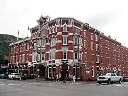
Main Avenue is a Nationally Registered Historic District that cuts through downtown Durango and is home to galleries, boutiques, restaurants, bars, and other businesses. Two notable and historic hotels, The General Palmer and The Strater, lie at the south end of the avenue, near the Durango & Silverton Narrow Gauge Railroad depot. With its combination of historic architecture, entertainment, and shopping, Main Avenue has historically comprised the center of Durango and is a popular year-round tourist destination.
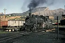
Durango & Silverton Narrow Gauge Railroad
Durango is known worldwide for the Durango & Silverton Narrow Gauge Railroad, a heritage railway that travels from Durango to the historic mining town of Silverton, Colorado via steam-powered trains. The history of the town and the D&SNG are inextricably woven, dating back to the 1880s.
Animas River Valley
The Animas River Valley begins in the heart of the San Juan Mountains and runs through downtown Durango. It boasts gold medal fly fishing waters and is popular for whitewater rafting, kayaking and canoeing. On warm summer afternoons a popular diversion is to buy an inflated inner tube and float from Animas City to Schneider Park or below.
Purgatory Resort
Purgatory Resort, located 25 miles north of downtown Durango, has 99 trails, 12 lifts, a vertical drop of over 2,000 feet, and more than 1,500 acres of skiable terrain. The resort features lodging, ski rentals, shopping, and dining. Purgatory is also a popular summertime recreation destination.
Snowdown Festival
Durango is home to Snowdown, an annual midwinter event popular for its Parade of Lights and other events. The event lasts 5 days, with competitions and costumes.
Music in the Mountains
Music in the Mountains is an annual classical summer music festival with performances at Purgatory Resort, Ft. Lewis College, in downtown Durango, and Cortez.
As of 2019, the festival is no longer being held at Purgatory Resort.
Durango Ragtime & Early Jazz Festival
The annual Durango Ragtime & Early Jazz Festival features noted musicians from around the country. It is held in the Strater Hotel, a historic Victorian hotel in Durango.
Iron Horse Bicycle Classic
Founded in 1972, the Iron Horse is a 61 mile bicycle road race held annually in Durango, CO. Every year cyclist from around the world come together and race the Durango Narrow Gauge Train on its journey from Durango to Silverton.
Media
Durango has a number of media outlets, which include The Durango Herald, 99x Durango, The Point, KDGO, XRock 105.3, KDUR 91.9/93.9, Four Corners Broadcasting (KIQX 101.3, KRSJ 100.5, KKDC 93.3, and KKDC AM 930) and many others.
Infrastructure
Transportation
Durango is served by U.S. Highway 160 (the Old Spanish Trail), running east–west, and U.S. Highway 550, running north–south. Part of U.S. 550 offers high-speed access (primarily a 4-lane, divided highway) to Albuquerque, New Mexico. North of Durango, 550 is nicknamed the Million Dollar Highway, and is part of the scenic San Juan Skyway.
Durango is served by a major regional airport for southwestern Colorado, Durango-La Plata Regional Airport, near Ignacio. Durango-La Plata County Airport (IATA code: DRO) is serviced year-round by regional carriers Mesa Airlines (American Eagle), SkyWest Airlines (American Eagle and United Express), Republic Airways (United Express), and American Eagle (Envoy Air).
As of 2014, regional connecting hubs to DRO include Dallas/Fort Worth International Airport (DFW), Phoenix Sky Harbor International Airport (PHX), and Denver International Airport (DEN).
Durango Transit provides several loop bus routes in the community, including Fort Lewis College. Normal hours of operation are weekdays from 6:30 am to 6:30 pm. Ignacio Road Runner provides bus service to the nearby towns of Ignacio, Colorado and Bayfield, with four trips daily on weekdays and one on Saturdays. Both services share the Durango Transit Center as a hub.
Greyhound Bus Lines formerly served Durango, but after budget cuts the service was discontinued. Since 2014, Road Runner Transit (a service of Southern Ute Community Action Programs) has restored daily bus service between Grand Junction and Durango.[17] Since 2018, Road Runner's service has been incorporated into the larger mantle of the state-run program Bustang.[18]
Durango is served by the Durango and Silverton Narrow Gauge Railroad.
Colleges
- Fort Lewis College is on a 350 foot (110 m) mesa overlooking downtown Durango and is accredited by the Higher Learning Commission. As of 2014, 4,028 students were enrolled at FLC.[19] FLC is a public 4-year liberal arts college.
- Southwest Colorado Community College, a branch of Pueblo Community College, is in the Durango Highschool building on North Main Ave.
Notable people
- Paco Ahlgren, writer
- Ross Anderson, World Cup/professional speed skier, All-American record holder
- Steve Carlton, Baseball Hall of Fame pitcher
- James Garesche Ord, United States Army Major General, born at Fort Lewis near Durango
- Missy Giove, cyclist inducted into the Mountain Bike Hall of Fame
- Howard Grotts, cyclist
- Greg Herbold, cyclist inducted into the Mountain Bike Hall of Fame
- Sepp Kuss, cyclist
- Matt Miller, NFL offensive tackle for the Cleveland Browns
- Ned Overend, cyclist inducted into the Mountain Bike Hall of Fame and the United States Bicycling Hall of Fame
- Stuart Roosa, NASA astronaut and former USFS Smoke Jumper, carried Redwood seeds on the Apollo 14 Moon mission which are now planted in several US parks
- Ed Stasium, record producer
- Tom Tully, actor, Oscar nominee for The Caine Mutiny
- Shan Wells, sculptor and illustrator
- Todd Wells, cyclist
Sister cities
Durango has two sister cities, as designated by Sister Cities International:
References in television and film
- Much of the 1953 western movie The Naked Spur starring James Stewart was shot in Durango.[20]
- Several parts of the 1955 western film Run for Cover starring James Cagney, were filmed just north of Durango in and around the upper Hermosa Valley area.[21]
- Portions of the 1957 western Night Passage starring a returning James Stewart, as well as Audie Murphy and Brandon DeWilde were filmed near Durango and on the Durango-Silverton Narrow Gauge Railway.[22]
- In 1965, Rosemary DeCamp played Durango newspaper editor Caroline Romney in the episode, "Mrs. Romney and the Outlaws" of the syndicated television series, Death Valley Days. In the story line, Romney sounds the alarm for citizens to fight the Kimball/Sykes gang. Willard Sage played Marshal Christy.[23]
- Parts of the 1969 film Butch Cassidy and the Sundance Kid were filmed north of town along the Animas River.[24][25]
- The television series Cannon, episode "Sky Above, Death Below" was filmed in and around Durango, Purgatory Resort, and Chimney Rock.[26]
- Part of the 1991 film City Slickers was shot in Durango.[27]
- The 1999 movie Durango Kids describes a time tunnel in the old mines outside of Durango.[28]
- Parts of the 1993 film Cliffhanger were shot in Durango.[29]
- The 1978 Roger Corman film Avalanche, starring Rock Hudson and Mia Farrow, was filmed mainly at Durango Mountain Resort and at the Lodge at Tamarron in north Durango.[30]
See also
- Outline of Colorado
- State of Colorado
- Colorado cities and towns
- Colorado counties
- Colorado metropolitan areas
- Durango Herald
- Durango-Silverton Narrow-Gauge Railroad National Historic District
- Durango Telegraph
- Old Spanish National Historic Trail
References
- "Active Colorado Municipalities". State of Colorado, Colorado Department of Local Affairs, Division of Local Government. Retrieved January 26, 2021.
- "2014 U.S. Gazetteer Files: Places". United States Census Bureau. July 1, 2014. Retrieved January 5, 2015.
- "Colorado Counties". State of Colorado, Colorado Department of Local Affairs, Division of Local Government. Retrieved January 26, 2021.
- "Colorado Municipal Incorporations". State of Colorado, Department of Personnel & Administration, Colorado State Archives. 2004-12-01. Retrieved 2007-09-02.
- "Current City Council". City of Durango.
- "Current City Council". City of Durango. Archived from the original on 2010-11-22.
- "2019 U.S. Gazetteer Files". United States Census Bureau. Retrieved July 1, 2020.
- "Population and Housing Unit Estimates". United States Census Bureau. May 24, 2020. Retrieved May 27, 2020.
- "ZIP Code Lookup". United States Postal Service. Archived from the original (JavaScript/HTML) on November 4, 2010. Retrieved September 8, 2007.
- "Find a County". National Association of Counties. Archived from the original on 2012-07-12. Retrieved 2011-06-07.
- Nossaman, Allen (19998). Many More Mountains Vol. 3: Rails into Silverton.
- "DURANGO, COLORADO - Climate Summary". Wrcc.dri.edu. Retrieved 27 August 2017.
- "Zipcode 81301 - Durango, Colorado Hardiness Zones". Plantmaps.com. Retrieved 27 August 2017.
- "DURANGO, COLORADO (052441)". Western Regional Climate Center. Retrieved June 3, 2016.
- "Census of Population and Housing". Census.gov. Retrieved June 4, 2015.
- "U.S. Census website". United States Census Bureau. Retrieved 2008-01-31.
- Friday, Dale Rodebaugh Reporter; 11, July; Sunday, 2014 11:12 AM Updated; 13, July; Pm, 2014 3:47. "Bus service to Grand Junction to resume". Durango Herald. Retrieved 27 August 2017.CS1 maint: numeric names: authors list (link)
- Armijo, Patrick (December 31, 2017). "Road Runner bus line to join state network". The Durango Herald.
- "College in Colorado - Facts about Fort Lewis College". Fortlewis.edu. Retrieved 27 August 2017.
- "The Naked Spur (1953)". IMDb.com. Retrieved 27 August 2017.
- "Run for Cover (1955)". IMDb.com. Retrieved 27 August 2017.
- "Night Passage (1957)". IMDb.com. Retrieved 27 August 2017.
- "Mrs. Romney and the Outlaws". Internet Movie Data Base. December 23, 1965. Retrieved September 1, 2015.
- "Where they filmed Butch Cassidy and the Sundance Kid (1969) from The Movie Map film locations guide". Themoviemap.com. Retrieved 27 August 2017.
- "Butch Cassidy and the Sundance Kid (1969)". IMDb.com. Retrieved 27 August 2017.
- IMDB: Cannon: Sky Above, Death Below , television series.
- IMDB: City Slickers (1991) - Filming locations
- IMDB: Durango Kids, motion picture.
- "Cliffhanger (1993)". IMDb.com. Retrieved 27 August 2017.
- IMDb.com https://www.imdb.com/title/tt0077189/?ref_=ttloc_loc_tt. Retrieved 22 August 2019. Missing or empty
|title=(help)
External links
| Wikimedia Commons has media related to Durango, Colorado. |
 Durango, Colorado travel guide from Wikivoyage
- City of Durango website
- Durango Ragtime and Early Jazz Festival website
Municipalities and communities of La Plata County, Colorado, United States | ||
|---|---|---|
| City | 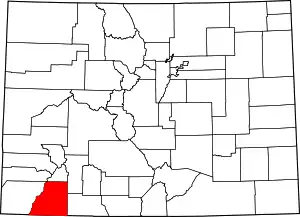 Map of Colorado highlighting La Plata County | |
| Towns | ||
| CDPs | ||
| Unincorporated communities | ||
| Indian reservations | ||
| Footnotes | ‡This populated place also has portions in an adjacent county or counties | |
| ||

| Authority control |
|---|