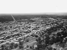
Charleville, Queensland
Charleville /ˈtʃɑːrlɛvɪl/ is a town and a locality in the Shire of Murweh, Queensland, Australia.[2][3] In the 2016 census, Charleville had a population of 3,335 people.[1]
| Charleville Queensland | |||||||||||||||
|---|---|---|---|---|---|---|---|---|---|---|---|---|---|---|---|
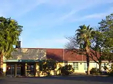
 The Royal Flying Doctor Service visitor centre at Charleville | |||||||||||||||
 Charleville | |||||||||||||||
| Coordinates | 26.4016°S 146.2383°E | ||||||||||||||
| Population | 3,335 (2016 census)[1] | ||||||||||||||
| • Density | 4.8481/km2 (12.5565/sq mi) | ||||||||||||||
| Established | 1865 | ||||||||||||||
| Postcode(s) | 4470 | ||||||||||||||
| Elevation | 293.5 m (963 ft) | ||||||||||||||
| Area | 687.9 km2 (265.6 sq mi) | ||||||||||||||
| Location | |||||||||||||||
| LGA(s) | Shire of Murweh | ||||||||||||||
| State electorate(s) | Warrego | ||||||||||||||
| Federal Division(s) | Maranoa | ||||||||||||||
| |||||||||||||||
| |||||||||||||||
Geography
Located in southwestern Queensland, Australia, Charleville is 683 kilometres (424 mi) west of Brisbane (the Queensland capital), 616 kilometres (384 mi) west of Toowoomba, 535 kilometres (333 mi) west of Dalby, 393 kilometres (244 mi) west of Miles and 254 kilometres (158 mi) west of Roma. It is the largest town and administrative centre of the Shire of Murweh, which covers an area of 43,905 square kilometres. Charleville is situated on the banks of the Warrego River, and is the terminus for the Warrego Highway which stretches 683 kilometres (424 mi) from Brisbane.
the Mitchell Highway also connects Charleville with:
- Augathella - 84 kilometres (53 mi) north
- Wyandra - 124 kilometres (77 mi) south
- Cunnamulla - 198 kilometres (123 mi) south
- Bourke - 454 kilometres (282 mi) south
- Dubbo - 825 kilometres (512 mi) south
- Sydney - 1212 kilometres (753 mi) south-east via Great Western Highway
History
Bidjara (also known as Bidyara, Pitjara, and Peechara) is an Australian Aboriginal language spoken by the Bidjara people. The Bidjara language region includes the local government areas of the Shire of Murweh, particularly the towns of Charleville, Augathella and Blackall as well as the properties of Nive Downs and Mount Tabor.[4]
Gungabula (also known as Kongabula and Khungabula) is an Australian Aboriginal language of the headwaters of the Dawson River in Central Queensland. The language region includes areas within the local government area of Maranoa Region, particularly the towns of Charleville, Augathella and Blackall and as well as the Carnarvon Range.[5]
The first European exploration of the area, which was Kunja tribal land, was conducted by Edmund Kennedy in 1847. A hotel was built in 1865, and a town began to grow to service the region. It was situated near Gowrie's Crossing, a permanent waterhole, now on the outskirts of the modern town. Gowrie Station had been established around the crossing along a natural stock route, for the grazing of sheep and cattle. The town was gazetted on 11 January 1865.[6] It was planned with very wide streets to enable bullock teams of up to 14 pairs to turn with their wagons.[7] It was William Alcock Tully, who was Commissioner of Crown Lands in the Warrego District from 1863 to 1864 and would later serve as Surveyor General of Queensland from 1875 to 1889, who laid out the town's streets. An Irishman, Tully probably named the town after the town of Charleville, County Cork, Ireland.[2][8] Members of the Roma-based Skinner family established a store in the town in 1872 that became known as the Warrego Stores.[9]
Charleville Post Office opened on 1 August 1865.[10]
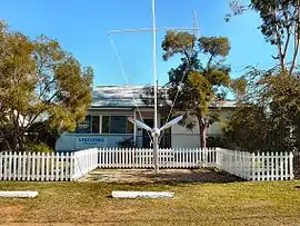
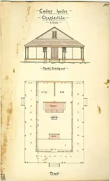
In September 1875, the Queensland Government called for tenders to erect a courthouse in Charleville.[11] The foundation stone (actually a bloodwood block) was laid on 23 November 1875.[12] By January 1876, the courthouse was almost finished.[13]
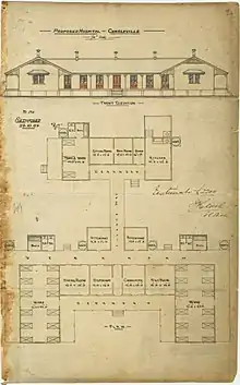

In December 1884, the Queensland Government called for tenders to erect a hospital in Charleville.[14] In March 1885 the contract was awarded to Richards and King for £2,265 10s.[15] In November 1885, a hospital ball was held in the new hospital building, suggesting it was completed and opened around that time.[16]
Cobb and Co, the legendary Australian stagecoach company, established a coach building business in the town in 1886, however, the railway arrived in 1888, beginning the long demise of coach transport in the area. Charleville station was the terminus for the Western railway line for more than a decade. Facilities included a locomotive depot, cattle and sheep yards, a 50-ton weighbridge, a booking and telegraph offices, goods shed, stationmaster's house, and guards, enginemen and firemen's cottages.[17]
In July 1886 the Anglican residents of the town decided to erect a church.[18] All Saint's Anglican Church was opened on by Rev. B. R. Wilson on 20 November 1887. It was designed by diocesan architect John Hingestone Buckeridge and built by Mr Wood.[19] It was dedicated in 1897. The foundation stone for the present church was laid in September 1957 by Archbishop Reginald Halse.[20] The new church was dedicated in 1958 and consecrated in 1967.[21]
In 1902 Charleville was the location of an unsuccessful attempt by Clement Lindley Wragge to fire cannons into the clouds in order to break a drought. The cannons used remain on display in Charleville today.
St Mary's Catholic Primary School was opened on 26 January 1913 by the Sisters of Mercy.[22][23]
In 1922, Qantas established an airmail service between Charleville and Cloncurry. At the same time, this was Qantas's first regularly scheduled route and the second scheduled air route in Australia.
On 9 October 1924, the Charleville War Memorial was unveiled by Sir Matthew Nathan, the Governor of Queensland.[24]
The Anglican Chapel of the Holy Angels Hostels was consecrated circa 1929. It closed circa 1984.[25]
Charleville was also one of the compulsory stop over/check points during the London to Melbourne MacRobertson Air Race in 1934. The winners of the great race were Tom Campbell Black and C. W. A. Scott. Their triumph was reported in Time magazine as:
"Scott and Black, keeping up their sensational pace, flashed into Charleville, refueled, sped toward the finish where waiting thousands cheered their progress, reported over loudspeakers. With one motor dead, with only two hours sleep since leaving England, the Britons triumphantly set their scarlet torpedo down in Melbourne at 3:34 p.m. In 71 hr. 1 min. 3 sec. – Just under three days – they had flown halfway around the world."[26]
Proximity to the Warrego River has been problematic. In April 1990, major floods hit western Queensland, with Charleville being badly affected. Floodwaters peaked at 8.54 metres, over 1,000 homes were inundated, and almost 3,000 people evacuated. More recently, the district suffered flooding again in 1997, 2008 and March 2010.[27][28] Flooding also occurred in February 2012.[29]
There is a children's book called The Flood Grungies; it is written by Michelle Sheehan and illustrated by Donna Reynolds. It is about the notorious Charleville floods and features the Cosmos centre, the water tower and other famous landmarks.[30]
Heritage listings
Charleville has a number of heritage-listed sites, including:
- 87 Alfred Street: former Queensland National Bank[31]
- Edward Street: Charleville War Memorial[32]
- King Street: Charleville railway station[17]
- Mitchell Highway: Landsborough's Blazed Tree (Camp 67)[33]
- 33 Wills Street: Hotel Corones[34]
as well as a number in nearby localities:
- 28 kilometres (17 mi) south-west of Charleville off the Diamantina Developmental Road in Bakers Bend: Myendetta Homestead[35]
- 29 kilometres (18 mi) south of Charleville off the Mitchell Highway in Bakers Bend: Landsborough's Blazed Tree (Camp 69)[36]
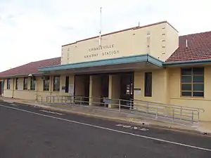 Railway station
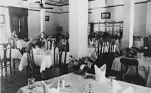 Dining room of the Hotel Corones
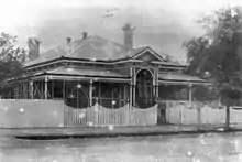 Queensland National Bank
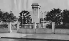 War memorial
Population
According to the 2016 census of Population, there were 3,335 people in Charleville.
- Aboriginal and Torres Strait Islander people made up 15.3% of the population.
- 83.6% of people were born in Australia. The next most common country of birth was Vietnam at 3.3%.
- 87.6% of people spoke only English at home. Other languages spoken at home included Vietnamese at 3.5%.
- The most common responses for religion were Catholic 34.1%, Anglican 24.1% and No Religion 17.2%,[1]
Climate
Charleville has a humid subtropical climate (Cfa) verging on semi-arid (BSk), with maximum temperatures ranging from 35 °C (95 °F) in summer to 20 °C (68 °F) in winter. Summers are hot and sultry, although they can be very dry as well depending on the wind direction. Winters are mild to cool and crisp, with rather high diurnal ranges, which provide some frost. Rainfall is mild and distributed patchily throughout the year, with a peak in summer. Severe flooding events are usually caused by monsoon troughs and the remnants of tropical cyclones dumping large amounts of rain over the area; however, rain normally falls in the form of thunderstorms and light showers after hot summer days. Extremes have ranged from 46.4 °C (115.5 °F) to −5.2 °C (22.6 °F). The highest rainfall total recorded for one month was 316.0 millimetres (12.44 in) in March 2010.[37]
| Climate data for Charleville (1942–2013) | |||||||||||||
|---|---|---|---|---|---|---|---|---|---|---|---|---|---|
| Month | Jan | Feb | Mar | Apr | May | Jun | Jul | Aug | Sep | Oct | Nov | Dec | Year |
| Record high °C (°F) | 46.4 (115.5) |
43.4 (110.1) |
40.7 (105.3) |
36.9 (98.4) |
32.4 (90.3) |
30.7 (87.3) |
30.1 (86.2) |
35.8 (96.4) |
38.5 (101.3) |
41.8 (107.2) |
43.3 (109.9) |
44.1 (111.4) |
46.4 (115.5) |
| Average high °C (°F) | 34.9 (94.8) |
33.8 (92.8) |
32.0 (89.6) |
28.1 (82.6) |
23.2 (73.8) |
19.8 (67.6) |
19.5 (67.1) |
21.9 (71.4) |
26.0 (78.8) |
29.7 (85.5) |
32.7 (90.9) |
34.6 (94.3) |
28.0 (82.4) |
| Average low °C (°F) | 21.7 (71.1) |
21.3 (70.3) |
18.7 (65.7) |
13.8 (56.8) |
8.9 (48.0) |
5.5 (41.9) |
4.2 (39.6) |
5.9 (42.6) |
9.9 (49.8) |
14.4 (57.9) |
17.9 (64.2) |
20.3 (68.5) |
13.9 (57.0) |
| Record low °C (°F) | 11.1 (52.0) |
9.4 (48.9) |
6.2 (43.2) |
0.8 (33.4) |
−3.6 (25.5) |
−4.4 (24.1) |
−5.2 (22.6) |
−4.0 (24.8) |
−0.4 (31.3) |
0.9 (33.6) |
6.0 (42.8) |
6.7 (44.1) |
−5.2 (22.6) |
| Average rainfall mm (inches) | 74.4 (2.93) |
69.7 (2.74) |
60.0 (2.36) |
30.9 (1.22) |
31.5 (1.24) |
24.6 (0.97) |
25.0 (0.98) |
19.5 (0.77) |
23.8 (0.94) |
36.7 (1.44) |
45.1 (1.78) |
56.2 (2.21) |
497.4 (19.58) |
| Average rainy days (≥ 0.2mm) | 7.7 | 6.4 | 5.3 | 3.7 | 3.9 | 3.9 | 4.0 | 3.4 | 3.6 | 5.6 | 6.1 | 7.4 | 61 |
| Source: Bureau of Meteorology[37] | |||||||||||||
Attractions
Charleville has several tourist attractions, including a museum of the Royal Flying Doctor Service of Australia, a historical museum,[38] wildlife sanctuary (including a bilby reserve), and the Cosmos Centre.[39]
Education
Charleville State School is a government primary (Early Childhood-6) school for boys and girls at Wills Street (26.4048°S 146.2423°E).[40][41] In 2018, the school had an enrolment of 205 students with 20 teachers (19 full-time equivalent) and 22 non-teaching staff (16 full-time equivalent).[42] It includes a special education program.[40]
St Mary's School is a Catholic primary (Prep-6) school for boys and girls at 66 Watson Street (26.4036°S 146.2431°E).[40][43] In 2018, the school had an enrolment of 117 students with 9 teachers (8 full-time equivalent) and 9 non-teaching staff (4 full-time equivalent).[42]
Charleville State High School is a government secondary (7-12) school for boys and girls on the corner of Partridge & Hunter Streets (26.3974°S 146.2574°E).[40][44] In 2018, the school had an enrolment of 246 students (including students from Augathella, Morven and Wyandra) with 36 teachers (34 full-time equivalent) and 21 non-teaching staff (16 full-time equivalent).[42] It includes a special education program.[40]
Charleville School of Distance Education is a government primary and secondary (Early Childhood-10) school for boys and girls at Parry Street (26.3950°S 146.2586°E).[40][45] In 2018, the school had an enrolment of 200 students with 25 teachers (24 full-time equivalent) and 12 non-teaching staff (10 full-time equivalent).[42] It is a School of the Air, providing distance education by a combination of postal services, telephone and Internet to children who are unable to attend a regular school due to their remote location.
Facilities
Charleville has a range of facilities for the community including a swimming pool, bowling green, speedway, racing course, and the Gowrie sporting oval.[46]
There is a public library on Alfred Street run by the Murweh Shire Council with a high-speed ISDN Internet Connection (through the National Broadband Network) to Brisbane.[47]
The Charleville branch of the Queensland Country Women's Association has its rooms at 145 Alfred Street.[48]
The Charleville Golf Course has eighteen sand greens and a licensed clubhouse in May Street.[49][50]
The Charleville Bowls Club has two rinks and a licensed clubhouse in Epacris Street.
All Saints Anglican Church is at 41 Alfred Street (26.4026°S 146.2374°E).[21]
North of the town is VMC, a marine weather transmitter operated by the Bureau of Meteorology.[51]
Media
The local newspaper is the Western Times. Along with many other regional Australian newspapers owned by NewsCorp, the newspaper ceased print editions in June 2020 and became an online-only publication from 26 June 2020.[52]
Transport
Aviation is served by the Charleville Airport. The Westlander rail passenger service links the town to Brisbane. Charleville would have been the southern end of the Transcontinental railway proposed in the 1880s, connecting to Point Parker on the Gulf of Carpentaria.
Charleville is also serviced by Bus Queensland who operates daily coach services to and from Brisbane via Toowoomba, Dalby, Chinchilla, Miles, Roma, Mitchell and Morven and vice-versa. Charleville is also a scheduled stop for Bus Queensland's daily services from Brisbane to Mount Isa and vice-versa
| Preceding station | Queensland Rail | Following station | ||
|---|---|---|---|---|
| Morven towards Brisbane |
The Westlander | Terminus | ||
Notable people
- Davida Allen (born 1951), painter, film maker and writer
- Daryl Beattie (born 1970), former professional Grand Prix motorcycle racer and television motor sports commentator
- Richard Bell (born 1953), artist and political activist
- Cameron Boyce (born 1989), first-class cricketer
- Luke Capewell (born 1989), National Rugby League footballer
- Andrew Dutney (born 1958), President of the Assembly of the Uniting Church in Australia
- Peter Everett, television presenter
- Richard Graham (born 1972), Australian Rugby Union coach
- Rhan Hooper (born 1988), former professional Australian rules footballer
- Chelsea Jane (born 1992), rapper and songwriter
- Matthew Mott (born 1973), former first-class cricketer and coach
- Libby Munro (born 1981), actress
- Billy Rogers (born 1989), National Rugby League footballer
- Neil Turner (1934–2011), politician
- Adrian Vowles (born 1971), former National Rugby League footballer
In popular culture
- An eponymous country music song about Charleville was written by Don Walker and recorded by Slim Dusty on his album Ringer from the Top End and later by Walker's own band Catfish on the album Ruby.
- The asteroid 13933 Charleville is named in the town's honour †.
References
- Australian Bureau of Statistics (27 June 2017). "Charleville (SSC)". 2016 Census QuickStats. Retrieved 14 December 2017.

- "Charleville – town in Shire of Murweh (entry 6893)". Queensland Place Names. Queensland Government. Retrieved 22 October 2017.
- "Charleville – locality in Shire of Murweh (entry 49244)". Queensland Place Names. Queensland Government. Retrieved 22 October 2017.
- "Bidjara". State Library of Queensland. Archived from the original on 25 September 2020. Retrieved 15 January 2020.
-
 This Wikipedia article incorporates CC-BY-4.0 licensed text from: "Gungabula". Queensland Aboriginal and Torres Strait Islander languages map. State Library of Queensland. Retrieved 28 January 2020.
- "Town reserve of Charleville —2,560 acres — Warrego District". Queensland Government Gazette. 11 January 1865. p. 6:27.
- Finn, J. T., One Hundred Years 1847–1947 Charleville (Charleville, 1947), p. 32
- "Charleville". Centre for the Government of Queensland. Archived from the original on 19 October 2012. Retrieved 20 June 2012.
- Wagner, Clair, Frontier Town – Charleville 1865–1901 (Bollarong Publications, Brisbane, 1991) p. 27
- Phoenix Auctions History. "Post Office List". Phoenix Auctions. Retrieved 18 January 2021.
- "Official Notifications". The Brisbane Courier. XXX (2, 594). Queensland, Australia. 13 September 1875. p. 3. Archived from the original on 4 December 2020. Retrieved 22 October 2017 – via National Library of Australia.
- "CHARLEVILLE". Western Star And Roma Advertiser. I (37). Queensland, Australia. 4 December 1875. p. 3. Archived from the original on 4 December 2020. Retrieved 22 October 2017 – via National Library of Australia.
- "CHARLEVILLE". The Darling Downs Gazette And General Advertiser. XVII (2347). Queensland, Australia. 1 January 1876. p. 2 (SUPPLEMENT TO THE GAZETTE.). Archived from the original on 25 September 2020. Retrieved 22 October 2017 – via National Library of Australia.
- "Official Notifications". The Queenslander. XXVI (483). Queensland, Australia. 27 December 1884. p. 1045. Archived from the original on 25 September 2020. Retrieved 22 October 2017 – via National Library of Australia.
- "Official Notifications". The Queenslander. XXVII (493). Queensland, Australia. 7 March 1885. p. 390. Archived from the original on 25 September 2020. Retrieved 22 October 2017 – via National Library of Australia.
- "CHARLEVILLE". The Brisbane Courier. XL (8, 690). Queensland, Australia. 20 November 1885. p. 6. Archived from the original on 25 September 2020. Retrieved 22 October 2017 – via National Library of Australia.
- "Charleville Railway Station (entry 602368)". Queensland Heritage Register. Queensland Heritage Council. Retrieved 11 July 2013.
- "Clippings from all Sources". Western Star And Roma Advertiser (785). Queensland, Australia. 28 July 1886. p. 3. Archived from the original on 4 December 2020. Retrieved 26 September 2020 – via National Library of Australia.
- "Church Chronicles – C". Anglican Diocese of Brisbane. Archived from the original on 2 March 2019. Retrieved 26 September 2020.
- "All Saints Anglican Church". Churches Australia. Archived from the original on 25 September 2020. Retrieved 25 September 2020.
- "Year Book" (PDF). Anglican Archdiocese of Brisbane. 2019. p. 138. Archived (PDF) from the original on 15 September 2020. Retrieved 15 September 2020.
- Queensland Family History Society (2010), Queensland schools past and present (Version 1.01 ed.), Queensland Family History Society, ISBN 978-1-921171-26-0
- "Our History". St Mary's Catholic Primary School, Charleville. Archived from the original on 20 November 2019. Retrieved 20 November 2019.
- "Charleville War Memorial". Monument Australia. Archived from the original on 7 April 2014. Retrieved 6 April 2014.
- "Closed Anglican Churches". Anglican Church South Queensland. Archived from the original on 3 April 2019. Retrieved 29 June 2020.
- Time Magazine, 29 October 1934, Vol. XXIV, No. 18
- "Charleville waits for floods to peak". The Sydney Morning Herald. 17 January 2008. Archived from the original on 25 April 2019. Retrieved 20 January 2008.
- "Qld flood crisis far from over". ABC News. 3 March 2010. Archived from the original on 5 March 2010. Retrieved 3 March 2010.
- "Levee holds at Charleville". ABC News. 6 February 2012. Archived from the original on 7 February 2012. Retrieved 7 February 2012.
- Sheehan, Michelle (2003). The flood grungies. Charleville: M. Sheehan. ISBN 064642176X.
- "Queensland National Bank (former) (entry 600757)". Queensland Heritage Register. Queensland Heritage Council. Retrieved 11 July 2013.
- "Charleville War Memorial (entry 600758)". Queensland Heritage Register. Queensland Heritage Council. Retrieved 11 July 2013.
- "Landsborough's Blazed Tree, Camp 67 (entry 602716)". Queensland Heritage Register. Queensland Heritage Council. Retrieved 11 July 2013.
- "Hotel Corones, Charleville (entry 601282)". Queensland Heritage Register. Queensland Heritage Council. Retrieved 11 July 2013.
- "Myendetta (entry 602822)". Queensland Heritage Register. Queensland Heritage Council. Retrieved 5 September 2016.
- "Landsborough's Blazed Tree, Camp 69 (entry 602715)". Queensland Heritage Register. Queensland Heritage Council. Retrieved 11 July 2013.
- "Charleville Aero". Climate statistics for Australian locations. Bureau of Meteorology. 19 September 2013. Retrieved 21 September 2013.
- "Charleville Historical Museum". Archived from the original on 23 October 2009. Retrieved 29 November 2007.
- "Cosmos Centre". Archived from the original on 10 January 2013. Retrieved 15 June 2015.
- "State and non-state school details". Queensland Government. 9 July 2018. Archived from the original on 21 November 2018. Retrieved 21 November 2018.
- "Charleville State School". Archived from the original on 2 May 2012. Retrieved 21 November 2018.
- "ACARA School Profile 2018". Australian Curriculum, Assessment and Reporting Authority. Archived from the original on 27 August 2020. Retrieved 28 January 2020.
- "St Mary's School". Archived from the original on 10 December 2018. Retrieved 21 November 2018.
- "Charleville State High School". Archived from the original on 19 March 2020. Retrieved 21 November 2018.
- "Charleville School of Distance Education". Archived from the original on 27 May 2012. Retrieved 21 November 2018.
- "Charleville". Centre for the Government of Queensland. Archived from the original on 18 January 2011. Retrieved 18 January 2011.
- "Charleville Library (Public Libraries Connect)". State Library of Queensland. Archived from the original on 13 December 2017. Retrieved 13 December 2017.
- "Find your closest branch". Queensland Country Women's Association. Archived from the original on 25 June 2020. Retrieved 18 July 2020.
- "Charleville Golf Club". Archived from the original on 28 April 2019. Retrieved 28 April 2019.
- "Charleville Golf Club". golfer.com.au. Archived from the original on 6 November 2014. Retrieved 6 November 2014.
- "Charleville ( VMC) Specifications". Bureau of Meteorology. Archived from the original on 22 June 2013. Retrieved 26 August 2013.
- "Future is digital: News announces major changes". Gatton Star. 28 May 2020. Archived from the original on 22 December 2020. Retrieved 22 December 2020.
![]() This Wikipedia article incorporates text from HOTEL CORONES, CHARLEVILLE (22 November 2019) published by the State Library of Queensland under CC-BY licence, accessed on 15 January 2020.
This Wikipedia article incorporates text from HOTEL CORONES, CHARLEVILLE (22 November 2019) published by the State Library of Queensland under CC-BY licence, accessed on 15 January 2020.
External links
| Wikivoyage has a travel guide for Charleville. |
![]() Media related to Charleville, Queensland at Wikimedia Commons
Media related to Charleville, Queensland at Wikimedia Commons
- University of Queensland: Queensland Places: Charleville
- Murweh Shire Council – Official site
- Weather Information
- About Charleville
- "How a city was created in the great South West". The Brisbane Courier. National Library of Australia. 6 March 1925. p. 11.
| Authority control |
|---|