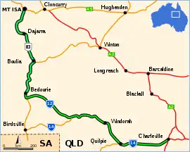
Diamantina Developmental Road
The Diamantina Developmental Road is a gazetted road in Queensland, Australia. that runs from Charleville in the south-central part of the state to Mount Isa in the north-west.[1]
Diamantina Developmental Road | |
|---|---|
 | |
Diamantina Developmental Road (green on black). | |
| General information | |
| Type | Rural road |
| Length | 1,344 km (835 mi) |
| Route number(s) |
|
| Major junctions | |
| South-east end | |
| |
| North-west end | |
| Location(s) | |
| Major settlements | Quilpie, Windorah, Bedourie, Boulia, Dajarra |
Route description
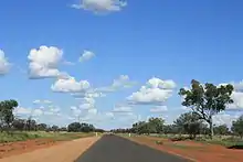
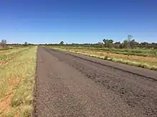
The road passes through the towns of Quilpie, Eromanga, Windorah, Bedourie, Boulia, and Dajarra in its 1344 kilometer length, and most of it is sealed.[2] Some sections between Windorah and Boulia are unsealed. The section from Boulia to Mount Isa is also known as the Boulia Mount Isa Highway and the section from Bedourie to Boulia is also known as the Boulia Bedourie Road. The section from the Eromanga boundary to the Windorah CBD is also known as the Quilpie Windorah Road. The road crosses several well known rivers and creeks of the Channel Country of south-west Queensland, including the Paroo River, Bulloo River, Cooper Creek and Diamantina River.
Responsible authority
Maintenance of the road is the responsibility of the Queensland Government.[1]
Major intersections
| LGA | Location | km | mi | Destinations | Notes |
|---|---|---|---|---|---|
| Murweh | Charleville | 0 | 0.0 | south - Cunnamulla | South-eastern end of Diamantina Developmental Road (State Route 14) |
| Quilpie | Quilpie | 197 | 122 | Quilpie Adavale Road - north - Adavale | |
| 212 | 132 | Quilpie Thargomindah Road - south - Thargomindah | |||
| 247 | 153 | Cooper Developmental Road - west - Eromanga | |||
| Quilpie / Barcoo boundary | Eromanga / Windorah boundary | 385 | 239 | Name changes to Quilpie Windorah Road | |
| Barcoo | Windorah | 450 | 280 | Thomson Developmental Road is part of a former proposed National Route 79 from Melbourne to Longreach. This route is now signed as M79/A79 from Melbourne to Mildura, then B79 to Broken Hill, beyond which there is no signed number.[3] | |
| 456 | 283 | Name reverts to Diamantina Developmental Road as it passes through Windorah CBD | |||
| 566 | 352 | Road changes to State Route 12 | |||
| Diamantina | Bedourie | 824 | 512 | Road changes to National Route 83 | |
| 847 | 526 | Name changes to Boulia Bedourie Road as it passes through Bedourie CBD | |||
| Boulia | Boulia | 1,038 | 645 | Name changes to Boulia Mount Isa Highway | |
| 1,048 | 651 | Donohue Highway - west - Queensland / Northern Territory border, where it becomes Plenty Highway (NT State Route 12) | |||
| Mount Isa | Mount Isa | 1,344 | 835 | North-western end of Diamantina Developmental Road | |
1.000 mi = 1.609 km; 1.000 km = 0.621 mi
| |||||
References
- Queensland Government - Department of Transport and Main Roads - Maps
- Hema, Maps (2007). Australia Road and 4WD Atlas (Map). Eight Mile Plains Queensland: Hema Maps. pp. 16, 17, 18, 19. ISBN 978-1-86500-456-3.
- "National Route 79". ozroads.com.au. Retrieved 10 January 2017.