Cunnamulla
Cunnamulla /kʌnəˈmʌlə/[2] is a town and a locality in the Shire of Paroo, Queensland, Australia.[3][4] It is 206 kilometres (128 mi) south of Charleville, and approximately 750 kilometres (470 mi) west of the state capital, Brisbane. In the 2016 census, Cunnamulla had a population of 1,140 people.[1]
| Cunnamulla Queensland | |||||||||||||||
|---|---|---|---|---|---|---|---|---|---|---|---|---|---|---|---|
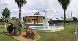 Cunnamulla war memorial, 2010 | |||||||||||||||
 Cunnamulla | |||||||||||||||
| Coordinates | 28.0702°S 145.6825°E | ||||||||||||||
| Population | 1,140 (2016 census)[1] | ||||||||||||||
| • Density | 0.2483/km2 (0.6431/sq mi) | ||||||||||||||
| Established | 1868 | ||||||||||||||
| Postcode(s) | 4490 | ||||||||||||||
| Elevation | 189 m (620 ft) | ||||||||||||||
| Area | 4,591.1 km2 (1,772.6 sq mi) | ||||||||||||||
| Time zone | AEST (UTC+10:00) | ||||||||||||||
| Location |
| ||||||||||||||
| LGA(s) | Shire of Paroo | ||||||||||||||
| County | Wellington County, Queensland | ||||||||||||||
| State electorate(s) | Warrego | ||||||||||||||
| Federal Division(s) | Maranoa | ||||||||||||||
| |||||||||||||||
| |||||||||||||||
Geography
Cunnamulla lies on the Warrego River in South West Queensland within the Murray-Darling drainage basin. It flows from the north (Coongoola) through the town, which is in the centre of the locality, and exits to the south (Tuen).[5]
The Mitchell Highway passes through the locality from north (Coongoola) to south (Tuen), while the Balonne Highway enters the location from the east (Linden). The two highways intersect in the town, which is located in the centre of the locality. The Bulloo Developmental Road starts in Cunnamulla and exists the locality to the west (Eulo).[5]
Cunnamulla is the administrative centre for the Paroo Shire, which also includes the townships of Wyandra, Yowah and Eulo, and covers an area of 47,617 square kilometres (18,385 sq mi).
Major industries of the area are wool, pig and kangaroo hunting, and the hospitality industry.
History
Gunya (also known as Kunya, Kunja, Kurnja) is an Australian Aboriginal language spoken by the Gunya people. The Gunya language region includes the landscape within the local government boundaries of the Paroo Shire Council, taking in Cunnamulla and extending north towards Augathella, east towards Bollon and west towards Thargomindah.[6]
The original Indigenous inhabitants of the area were the Kunja. The area's first European explorer was Thomas Mitchell who passed through the region in 1846.[7]
The town name Cunnamulla is named after a pastoral property established in 1867, which in turn is the Aboriginal name of a deep waterhole in the Warrego River.[3]
A settlement arose here because there was a reliable waterhole where two major stock routes intersected.[8] The town itself came into being in the late 19th century as a coach stop for Cobb and Co coaches.[7] A town survey was conducted in 1868, the same year a courthouse was built.[8] Cunnamulla Post Office opened on 1 March 1868.[9]
Cunnamulla Provisional School opened on 9 July 1877, becoming Cunnamulla State School in 1885.[10]
From 1885 when the railway was constructed to Bourke in New South Wales, farmers at Cunnamulla and other parts of south-western Queensland began to send their wool to markets via Bourke rather than the Charleville, then the terminus of the Western railway line in Queensland, as the New South Wales government offered more competitive rail freight rates than the Queensland Government. Queensland Railway Commissioner James Thallon responded by negotiating with the Carrier's Union which carried goods to the Charleville railhead to make the cost of transporting the goods via Charleville more attractive. However, strikes by the carriers in support of the 1891 Australian shearers' strike meant that goods continued to be travel via New South Wales, further encouraged by new lower freight rates in New South Wales announced in June 1893. The Queensland Government responded the following month by introducing the Railway Border Tax Act which taxed wool and sheepskins crossing the border into New South Wales to make it too expensive to freight the wool via New South Wales.[11] However, this could only be a temporary measure as the anticipated Federation of Australia would likely include free trade between the states of Australia removing the ability to tax goods at the border crossing. Therefore, on 3 December 1895, the Queensland Parliament approved the construction of the 121-mile (195 km) extension of the Western railway line from Charleville to Cunnamulla.[12][13]
During the construction of the railway line, there was a dispute over the location of the railway station at Cunnamulla. The original proposal was for the station to be to the north of the town to be above the flood level rather than within the town centre as was usual practice. However, the railway chief engineer Henry Charles Stanley visited Cunnamulla and decided it would be better to place the station in the centre of the town as it would be more convenient and better positioned for crossing the Warrego River when the railway line was further extended. However, the disadvantage of the town centre site was that it would encroach on the town's cricket ground. The townsfolk were divided on the issue and many sent petitions to the government to demand one location or the other.[14][15] The Queensland Parliament eventually decided to proceed with the original location north of the town.[16][13] The railway line to Cunnamulla was opened on 10 October 1898.[13] However, the hotel on the corner of John and Louise Streets in the centre of the town had already been named the Railway Hotel in anticipation of a town-centre station and retained that name until the 1970s, when it was renamed Trappers Inn.[17]
A Catholic church opened in Cunnamulla in May 1894.[18]
The Bush Brotherhood of St Paul has provided pastoral care to Cunnamulla since 1905.[19]
The Sacred Heart Primary School was opened in 1915 by the Sisters of Mercy.[10][20]
St Edmund's Anglican church was dedicated on 22 October 1960 by Archbishop Reginald Halse. Its closure on 28 May 2003 was approved by Venerable G. F. Harch, Archdeacon of the West.[21]
In 1999 the Queensland Department of Aboriginal and Torres Strait Islander Policy and Development reported that Cunnamulla's indigenous community suffered from a high level of domestic violence stemming from an over reliance by the police and the courts on punishment and detention to deal with Indigenous offenders.[22]
The Cunnamulla library underwent a major refurbishment in 2013.[23]
Flooding
The town has experienced major flooding in 1990, 1997, 2010 and 2012. The 1990 flood set a record for the Warrego River at 10.15 metres (33 ft 4 in).[24] In 2008, the Australian Defence Force was deployed to assist in flood preparations.[25] An 11 m (36 ft) high levee protects the town.[26]
Heritage listings
Cunnamulla has a number of heritage-listed sites, including:
- John Street: Cunnamulla War Memorial Fountain[27]
- Civic Centre, Louise Street: Paroo Shire Honour Board[28]
- Stockyard Street: The Robbers Tree[29]
Population
According to the 2016 census of Population, there were 1,140 people in Cunnamulla.
- Aboriginal and Torres Strait Islander people made up 37.2% of the population.
- 88.7% of people were born in Australia and 91.5% of people spoke only English at home.
- The most common responses for religion were Catholic (34.5%), Anglican (27.8%), and No Religion (16.4%).[1]
Facilities
Cunnamulla has a magistrates court, public swimming pool, showground, racecourse, a primary health care facility and a fire station.[30] The Paroo Shire Council operates a public library in Cunnamulla at 16 John Street.[31]
St Albans Anglican Church is at 23 Emma Street.[32]
Attractions
There are two museums and a tourist information centre. The town has two caravan parks, one at the Warrego Riverside and the other within the town boundaries.
Education
Cunnamulla P-12 State School is a government primary and secondary (Early Childhood-12) school for boys and girls at 17 Francis Street (28.0711°S 145.6793°E).[33][34] In 2017, the school had an enrolment of 98 students with 17 teachers (16 full-time equivalent) and 20 non-teaching staff (14 full-time equivalent).[35]
Sacred Heart Primary School is a Catholic primary (Prep-6) school for boys and girls at 46 John Street (28.0725°S 145.6832°E).[33][36] In 2017, the school had an enrolment of 84 students with 8 teachers (7 full-time equivalent) and 5 non-teaching staff (4 full-time equivalent).[35]
Cultural references
Cunnamulla was the subject of a 2000 documentary film of the same name by Dennis O'Rourke, in which he followed several members of the community as they went about their daily lives. The film earned $132,485 at the Australian box office.[37]
Cunnamulla is the main setting for Henry Lawson's short story "The Hypnotised Township" from his anthology The Rising of the Court, and Other Sketches in Prose and Verse. The song "The Cunnamulla Fella", written by Stan Coster and sung by Slim Dusty, is commemorated by a statue in the town centre.[38]
Climate
| Climate data for Cunnamulla | |||||||||||||
|---|---|---|---|---|---|---|---|---|---|---|---|---|---|
| Month | Jan | Feb | Mar | Apr | May | Jun | Jul | Aug | Sep | Oct | Nov | Dec | Year |
| Record high °C (°F) | 47.2 (117.0) |
45.0 (113.0) |
43.3 (109.9) |
37.3 (99.1) |
32.7 (90.9) |
30.4 (86.7) |
29.4 (84.9) |
36.8 (98.2) |
38.2 (100.8) |
42.0 (107.6) |
44.0 (111.2) |
46.0 (114.8) |
47.2 (117.0) |
| Average high °C (°F) | 36.0 (96.8) |
34.8 (94.6) |
32.3 (90.1) |
28.0 (82.4) |
23.0 (73.4) |
19.3 (66.7) |
18.8 (65.8) |
21.4 (70.5) |
25.7 (78.3) |
29.7 (85.5) |
32.8 (91.0) |
35.2 (95.4) |
28.1 (82.6) |
| Average low °C (°F) | 22.2 (72.0) |
21.7 (71.1) |
18.8 (65.8) |
14.1 (57.4) |
9.8 (49.6) |
6.8 (44.2) |
5.7 (42.3) |
7.1 (44.8) |
10.7 (51.3) |
14.8 (58.6) |
18.1 (64.6) |
20.7 (69.3) |
14.2 (57.6) |
| Record low °C (°F) | 13.0 (55.4) |
11.5 (52.7) |
4.4 (39.9) |
4.6 (40.3) |
−1.1 (30.0) |
−2.2 (28.0) |
−2.2 (28.0) |
−1.0 (30.2) |
2.0 (35.6) |
3.3 (37.9) |
7.8 (46.0) |
11.5 (52.7) |
−2.2 (28.0) |
| Average precipitation mm (inches) | 47.5 (1.87) |
51.6 (2.03) |
41.1 (1.62) |
27.0 (1.06) |
29.9 (1.18) |
25.7 (1.01) |
22.8 (0.90) |
17.3 (0.68) |
18.3 (0.72) |
25.1 (0.99) |
30.7 (1.21) |
39.3 (1.55) |
376.2 (14.81) |
| Average precipitation days | 4.5 | 4.4 | 3.8 | 2.6 | 3.3 | 3.7 | 3.3 | 2.7 | 2.8 | 4.0 | 4.3 | 4.4 | 43.8 |
| Source: [39] | |||||||||||||
See also
References
- Australian Bureau of Statistics (27 June 2017). "Cunnamulla (SSC)". 2016 Census QuickStats. Retrieved 20 October 2018.

- Macquarie Dictionary, Fourth Edition (2005). Melbourne, The Macquarie Library Pty Ltd. ISBN 1-876429-14-3
- "Cunnamulla – town in Shire of Paroo (entry 9001)". Queensland Place Names. Queensland Government. Retrieved 11 June 2019.
- "Cunnamulla – locality in Shire of Paroo (entry 49186)". Queensland Place Names. Queensland Government. Retrieved 11 June 2019.
- "Queensland Globe". State of Queensland. Retrieved 23 July 2019.
- "Gunya". State Library of Queensland. 21 January 2020.
- "Cunnamulla - Queensland - Australia - Travel". The Sydney Morning Herald. 8 February 2004. Archived from the original on 7 November 2012. Retrieved 12 October 2010.
- Environmental Protection Agency (Queensland) (2002). Heritage Trails of the Queensland Outback. State of Queensland. p. 20. ISBN 0-7345-1040-3.
- Phoenix Auctions History. "Post Office List". Phoenix Auctions. Retrieved 6 February 2021.
- Queensland Family History Society (2010), Queensland schools past and present (Version 1.01 ed.), Queensland Family History Society, ISBN 978-1-921171-26-0
- "PARLIAMENT". The Week. XXXVI (918). Queensland, Australia. 28 July 1893. p. 9. Retrieved 24 July 2019 – via National Library of Australia.
- "PARLIAMENT". The Telegraph (7, 217). Queensland, Australia. 4 December 1895. p. 6. Retrieved 24 July 2019 – via National Library of Australia.
- Kerr, John (1990), Triumph of narrow gauge : a history of Queensland Railways, Boolarong Publications, pp. 81–82, ISBN 978-0-86439-102-5
- "THE CUNNAMULLA EXTENSION". The Brisbane Courier. LIII (12, 234). Queensland, Australia. 30 March 1897. p. 4. Retrieved 24 July 2019 – via National Library of Australia.
- "(LOGROLLING EXTRAORDINARY". The North Queensland Register. Queensland, Australia. 15 December 1897. p. 23. Retrieved 24 July 2019 – via National Library of Australia.
- "Tuesday's Parliament". Toowoomba Chronicle And Darling Downs General Advertiser (5609). Queensland, Australia. 2 December 1897. p. 2. Retrieved 24 July 2019 – via National Library of Australia.
- Information plaque on Trapper's Inn. Cunnamulla Pathways. 2019.
- "TO THE FAR SOUTH-WEST". The Brisbane Courier. L (11, 344). Queensland, Australia. 24 May 1894. p. 5. Retrieved 26 July 2019 – via National Library of Australia.
- "Cunnamulla St Alban's Anglican Church". Cunnamulla Tourist Info. Archived from the original on 22 February 2017. Retrieved 26 July 2019.
- "Sacred Heart Parish School". Sacred Heart Parish School. Archived from the original on 23 July 2019. Retrieved 23 July 2019.
- Anglican Church of Southern Queensland. "Closed Churches". Archived from the original on 3 April 2019. Retrieved 3 April 2019.
- "Aboriginal and Torres Strait Islander Women's Task Force on Violence" (PDF). Queensland Government. 1999. Archived from the original (PDF) on 17 September 2006. Retrieved 10 August 2007. p47
- "The Queensland Public Libraries Statistical Bulletin 2016–2017" (PDF). Public Libraries Connect. Archived (PDF) from the original on 30 January 2018. Retrieved 15 January 2018.
- "Levee holds at Charleville". ABC News. Australian Broadcasting Corporation. 6 February 2012. Archived from the original on 7 February 2012. Retrieved 7 February 2012.
- "Flooding disaster may cost farmers $1b". The Sydney Morning Herald. 22 January 2008. Archived from the original on 18 December 2011. Retrieved 7 February 2012.
- Felton-Taylor, Arlie; Phillips, Amy (23 February 2012). "Recovering from Queensland's 2012 flood". ABC Rural. Australian Broadcasting Corporation. Archived from the original on 23 July 2019. Retrieved 23 July 2019.
- "Cunnamulla War Memorial Fountain (entry 600760)". Queensland Heritage Register. Queensland Heritage Council. Retrieved 12 July 2013.
- "Paroo Shire Honour Board (entry 600761)". Queensland Heritage Register. Queensland Heritage Council. Retrieved 12 July 2013.
- "The Robbers Tree (entry 600762)". Queensland Heritage Register. Queensland Heritage Council. Retrieved 12 July 2013.
- "Cunnamulla". Centre for the Government of Queensland. Archived from the original on 13 April 2012. Retrieved 12 December 2011.
- "Cunnamulla Library". Public Libraries Connect. Archived from the original on 15 January 2018. Retrieved 15 January 2018.
- "Locations". Anglican Church of Southern Queensland. Retrieved 10 November 2019.
- "State and non-state school details". Queensland Government. 9 July 2018. Archived from the original on 21 November 2018. Retrieved 21 November 2018.
- "Cunnamulla P-12 State School". Archived from the original on 18 March 2020. Retrieved 1 August 2020.
- "ACARA School Profile 2017". Archived from the original on 22 November 2018. Retrieved 22 November 2018.
- "Sacred Heart Primary School". Archived from the original on 10 December 2018. Retrieved 21 November 2018.
- "Australian Films at the Australian Box Office", Film Victoria Archived 9 February 2014 at the Wayback Machine accessed 12 November 2012
- "Cunnamulla Fella". Tourism Queensland. Archived from the original on 22 July 2011. Retrieved 1 February 2010.
- "Climate statistics for Cunnamulla". Bureau of Meteorology. Archived from the original on 18 December 2014. Retrieved 18 December 2014.
External links
| Wikimedia Commons has media related to Cunnamulla, Queensland. |
| Wikisource has original text related to this article: |
| Authority control |
|---|