Chefornak Airport
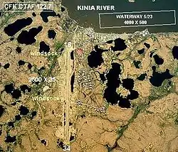
Chefornak Airport (IATA: CYF, ICAO: PACK, FAA LID: CFK) is a state-owned public-use airport in Chefornak,[1] a city in the Bethel Census Area of the U.S. state of Alaska. The airport is on the Kinia River.
Chefornak Airport | |||||||||||
|---|---|---|---|---|---|---|---|---|---|---|---|
 | |||||||||||
| Summary | |||||||||||
| Airport type | Public | ||||||||||
| Owner | State of Alaska DOT&PF | ||||||||||
| Serves | Chefornak, Alaska | ||||||||||
| Elevation AMSL | 40 ft / 12 m | ||||||||||
| Coordinates | 60°08′57″N 164°17′08″W | ||||||||||
| Map | |||||||||||
 CYF Location of airport in Alaska | |||||||||||
| Runways | |||||||||||
| |||||||||||
| Statistics (2015) | |||||||||||
| |||||||||||
Most U.S. airports use the same three-letter location identifier for the FAA and IATA, but this airport is assigned CFK by the FAA[1] and CYF by the IATA.[2] The airport's ICAO identifier is PACK.[3]
Facilities
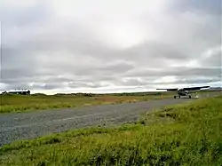
Chefornak Airport has one runway designated 16/34 with a gravel and dirt surface measuring 2,500 by 28 feet (762 x 9 m).[1]
A new airstrip has been built further out from the village due to concerns with the current airstrip being near the school and pedestrian traffic; however, the runway must settle for several years before it is ready to be used.
Airlines and destinations
| Airlines | Destinations |
|---|---|
| Grant Aviation | Bethel, Kipnuk, Toksook Bay[4] |
Prior to its bankruptcy and cessation of all operations, Ravn Alaska served the airport from multiple locations.
Statistics
| Carrier | Passengers (arriving and departing) |
|---|---|
| Hageland | 5,320(55.45%) |
| Yute Air | 2,950(30.74%) |
| Grant | 1,330(13.81%) |
| Rank | City | Airport | Passengers |
|---|---|---|---|
| 1 | Bethel Airport | 3,190 | |
| 2 | Toksook Bay Airport | 670 | |
| 3 | Kipnuk Airport | 260 | |
| 4 | Nightmute Airport | 260 | |
| 5 | Tununak Airport | 100 | |
| 6 | Kwigillingok Airport | 100 | |
| 7 | Tuntutuliak Airport | 70 | |
| 8 | Newtok Airport | 60 | |
| 9 | Kongiganak Airport | 20 | |
| 10 | Nunapitchuk Airport | 20 |
References
- FAA Airport Form 5010 for CFK PDF, effective January 5, 2017.
- Great Circle Mapper: CYF / PACK - Chefornak, Alaska
- "Alaskan ICAO Identifiers". Federal Aviation Administration. Archived from the original on 2009-07-28. Retrieved 2009-08-07.
- "Schedule". (retrieved January 15, 2017)
- "Chefornak, AK: Chefornak (CYF)". Bureau of Transportation Statistics (BTS), Research and Innovative Technology Administration (RITA), U.S. Department of Transportation. December 2015. Retrieved January 15, 2017.
External links
- Alaska FAA airport diagram (GIF)
- Resources for this airport:
- Airport information for PACK at AirNav
- Accident history for CYF at Aviation Safety Network
- Aeronautical chart and airport information for CFK at SkyVector