Kotlik Airport
Kotlik Airport (IATA: KOT[3], ICAO: PFKO[4], FAA LID: 2A9) is a state-owned public-use airport located one nautical mile (1.85 km) west of the central business district of Kotlik, a city in the Kusilvak Census Area of the U.S. state of Alaska.[1]
Kotlik Airport | |||||||||||
|---|---|---|---|---|---|---|---|---|---|---|---|
 | |||||||||||
| Summary | |||||||||||
| Airport type | Public | ||||||||||
| Owner | Alaska DOT&PF - Northern Region | ||||||||||
| Serves | Kotlik, Alaska | ||||||||||
| Elevation AMSL | 15 ft / 5 m | ||||||||||
| Coordinates | 63°01′50″N 163°31′58″W | ||||||||||
| Map | |||||||||||
 KOT Location of airport in Alaska | |||||||||||
| Runways | |||||||||||
| |||||||||||
| Statistics | |||||||||||
| |||||||||||
As per Federal Aviation Administration records, this airport had 4,117 passenger boardings (enplanements) in calendar year 2007, an increase of 14% from the 3,654 enplanements in 2006.[2]
Facilities
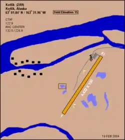
Kotlik Airport covers an area of 185 acres (75 ha) at an elevation of 15 feet (5 m) above mean sea level. It has one runway designated 2/20 with a 4,422 x 100 ft (1,348 x 30 m) gravel surface.[1]
Airlines and destinations
| Airlines | Destinations |
|---|---|
| Grant Aviation | Emmonak[5] |
Prior to its bankruptcy and cessation of all operations, Ravn Alaska served the airport from multiple locations.
Top destinations
| Rank | City | Passengers | Carriers |
|---|---|---|---|
| 1 | 1,000 | Hageland | |
| 2 | 1,000 | Hageland | |
References
- FAA Airport Form 5010 for 2A9 PDF, effective 2008-09-25.
- Preliminary CY 2007 Passenger Boarding and All-Cargo Data. Federal Aviation Administration. 2008-07-17.
- KOT: Kotlik Airport, Alaska. Aviation Safety Network. Retrieved 2008-09-21.
- PFKO: Kotlik Airport, Alaska. AirNav.com. Retrieved 2008-09-21.
- "Destinations". (retrieved December 20, 2020)
- http://www.transtats.bts.gov/airports.asp?pn=1&Airport=KOT&Airport_Name=Kotlik,%20AK:%20Kotlik%20Airport&carrier=FACTS
External links
- FAA Alaska airport diagram (GIF)
- FAA Terminal Procedures for 2A9, effective January 28, 2021
- Resources for this airport:
- FAA airport information for 2A9
- AirNav airport information for 2A9
- ASN accident history for KOT
- FlightAware airport information and live flight tracker
- SkyVector aeronautical chart for 2A9
This article is issued from Wikipedia. The text is licensed under Creative Commons - Attribution - Sharealike. Additional terms may apply for the media files.