Wainwright Airport (Alaska)
Wainwright Airport (IATA: AIN, ICAO: PAWI, FAA LID: AWI, formerly 5WW) is a public use airport located in Wainwright,[1] a city in the North Slope Borough of the U.S. state of Alaska. The airport is owned by the North Slope Borough.[1]
Wainwright Airport | |||||||||||
|---|---|---|---|---|---|---|---|---|---|---|---|
 | |||||||||||
| Summary | |||||||||||
| Airport type | Public | ||||||||||
| Owner | North Slope Borough | ||||||||||
| Serves | Wainwright, Alaska | ||||||||||
| Elevation AMSL | 45 ft / 14 m | ||||||||||
| Coordinates | 70°38′17″N 159°59′41″W | ||||||||||
| Map | |||||||||||
 AWI Location of airport in Alaska | |||||||||||
| Runways | |||||||||||
| |||||||||||
| Statistics (2006) | |||||||||||
| |||||||||||
As per Federal Aviation Administration records, the airport had 3,547 passenger boardings (enplanements) in calendar year 2008,[2] 3,770 enplanements in 2009, and 4,129 in 2010.[3] It is included in the National Plan of Integrated Airport Systems for 2011–2015, which categorized it as a non-primary commercial service airport (between 2,500 and 10,000 enplanements per year).[4]
Although many U.S. airports use the same three-letter location identifier for the FAA and IATA, this airport is assigned AWI by the FAA[1] and AIN by the IATA.[5] The airport's ICAO identifier is PAWI.[6][7]
History
The airport was built in 1957 to support the Distant Early Warning Line Radar station at Wainwright (LIZ-3). The station was logistically supported by the 711th Aircraft Control and Warning Squadron based at Cape Lisburne Air Force Station, although Point Lay was operated by civilian contract workers.
The radar station was upgraded in the late 1980s with new radars and in 1989 was re-designated part of the North Warning System (NWS) as a Long Range Radar Site, A-16, controlled by the Pacific Air Forces 611th Air Support Group, based at Elmendorf AFB.
The LRR site was inactivated in 2007 due to soil erosion and budget concerns. The airport remains open to support the small settlement. [8] [9]
Facilities and aircraft
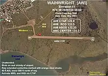
Wainwright Airport resides at elevation of 45 feet (14 m) above mean sea level. It has one runway designated 5/23 with a gravel surface measuring 4,494 by 110 feet (1,370 x 34 m).[1] For the 12-month period ending January 1, 2006, the airport had 1,100 aircraft operations, an average of 91 per month: 73% air taxi and 27% general aviation. [1]
Airlines and destinations
Prior to its bankruptcy and cessation of all operations, Ravn Alaska served the airport from multiple locations.
Statistics
| Carrier | Passengers (arriving and departing) |
|---|---|
| Hageland | 6,220(99.4%) |
| Era Aviation | 40(0.6%) |
| Rank | City | Airport | Passengers |
|---|---|---|---|
| 1 | Utqiagvik, AK | Wiley Post/Will Rogers Memorial (BRW) | 2,790 |
| 2 | Atqasuk, AK | Atqasuk Edward Burnell Sr. Memorial (ATK) | 180 |
References
- FAA Airport Form 5010 for AWI PDF. Federal Aviation Administration. effective November 15, 2012.
- "Enplanements for CY 2008" (PDF, 1.0 MB). 2008 Passenger Boarding and All-Cargo Data. Federal Aviation Administration. December 18, 2009.
- "Enplanements for CY 2010" (PDF, 189 KB). 2010 Passenger Boarding and All-Cargo Data. Federal Aviation Administration. October 4, 2011.
- "2011–2015 NPIAS Report, Appendix A" (PDF, 2.03 MB). National Plan of Integrated Airport Systems. Federal Aviation Administration. October 4, 2010.
- "IATA Airport Code Search (AIN: Wainwright)". International Air Transport Association. Retrieved July 27, 2013.
- "Alaskan ICAO Identifiers". Federal Aviation Administration. Retrieved August 7, 2009.
- "Wainwright Airport (IATA: AIN, ICAO: PAWI, FAA: AWI)". Great Circle Mapper. Retrieved August 7, 2009.
-
 This article incorporates public domain material from the Air Force Historical Research Agency website http://www.afhra.af.mil/.
 - The DEW Line
- "Wainwright, AK: Wainwright Airport (AIN)". Bureau of Transportation Statistics. December 2012. Retrieved July 27, 2013.
External links
- Airport diagram from FAA Alaska Region
- FAA Terminal Procedures for AWI, effective December 31, 2020
- Resources for this airport:
- FAA airport information for AWI
- AirNav airport information for PAWI
- ASN accident history for AIN
- FlightAware airport information and live flight tracker
- NOAA/NWS latest weather observations for PAWI
- SkyVector aeronautical chart for AWI