Chichester, New Hampshire
Chichester is a town in Merrimack County, New Hampshire, United States. The population was 2,523 at the 2010 census.[1]
Chichester, New Hampshire | |
|---|---|
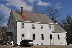 Chichester Grange Hall, which houses town offices, is listed in the State Register of Historic Places | |
 Seal | |
 Location in Merrimack County and the state of New Hampshire | |
| Coordinates: 43°14′57″N 71°23′59″W | |
| Country | United States |
| State | New Hampshire |
| County | Merrimack |
| Incorporated | 1727 |
| Villages | Chichester North Chichester |
| Government | |
| • Board of Selectmen | Richard Bouchard, Chair Ed Millette Jason Weir |
| • Town Administrator | Jodi Pinard |
| Area | |
| • Total | 21.2 sq mi (54.9 km2) |
| • Land | 21.1 sq mi (54.6 km2) |
| • Water | 0.1 sq mi (0.3 km2) 0.52% |
| Elevation | 538 ft (164 m) |
| Population (2010) | |
| • Total | 2,523 |
| • Density | 120/sq mi (46/km2) |
| Time zone | UTC-5 (Eastern) |
| • Summer (DST) | UTC-4 (Eastern) |
| ZIP code | 03258 |
| Area code(s) | 603 |
| FIPS code | 33-12420 |
| GNIS feature ID | 0873566 |
| Website | www.chichesternh.org |
History
Chichester was granted in 1727 to Nathaniel Gookin and others,[2] and was named for Thomas Pelham-Holles, 1st Duke of Newcastle-upon-Tyne, Earl of Chichester and England's Secretary of State for the Southern Department. The first settlement was commenced by Paul Morrill, in 1758.[2]
Geography
According to the United States Census Bureau, the town has a total area of 21.2 square miles (55 km2), of which 21.1 sq mi (55 km2) is land and 0.1 sq mi (0.26 km2) is water, comprising 0.52% of the town. The highest point in Chichester is an unnamed summit at 1,015 feet (309 m) above sea level, midway between Garvin Hill (985 ft or 300 m) to the east and Plausawa Hill (1,000 ft or 300 m) to the west in neighboring Pembroke. All three summits are less than one mile apart. Chichester lies fully within the Merrimack River watershed.[3]
Adjacent municipalities
- Loudon (northwest)
- Pittsfield (northeast)
- Epsom (east)
- Pembroke (south)
Demographics
| Historical population | |||
|---|---|---|---|
| Census | Pop. | %± | |
| 1790 | 491 | — | |
| 1800 | 775 | 57.8% | |
| 1810 | 951 | 22.7% | |
| 1820 | 1,010 | 6.2% | |
| 1830 | 1,084 | 7.3% | |
| 1840 | 1,028 | −5.2% | |
| 1850 | 997 | −3.0% | |
| 1860 | 1,041 | 4.4% | |
| 1870 | 871 | −16.3% | |
| 1880 | 784 | −10.0% | |
| 1890 | 661 | −15.7% | |
| 1900 | 598 | −9.5% | |
| 1910 | 606 | 1.3% | |
| 1920 | 507 | −16.3% | |
| 1930 | 567 | 11.8% | |
| 1940 | 587 | 3.5% | |
| 1950 | 735 | 25.2% | |
| 1960 | 821 | 11.7% | |
| 1970 | 1,083 | 31.9% | |
| 1980 | 1,492 | 37.8% | |
| 1990 | 1,942 | 30.2% | |
| 2000 | 2,236 | 15.1% | |
| 2010 | 2,523 | 12.8% | |
| 2017 (est.) | 2,645 | [4] | 4.8% |
| U.S. Decennial Census[5] | |||
As of the census[6] of 2000, there were 2,236 people, 823 households, and 637 families residing in the town. The population density was 106.1 people per square mile (41.0/km2). There were 849 housing units at an average density of 40.3 per square mile (15.6/km2). The racial makeup of the town was 98.17% White, 0.18% African American, 0.36% Native American, 0.13% Asian, 0.18% from other races, and 0.98% from two or more races. Hispanic or Latino of any race were 0.67% of the population.
There were 823 households, out of which 37.2% had children under the age of 18 living with them, 67.6% were married couples living together, 6.6% had a female householder with no husband present, and 22.5% were non-families. 17.1% of all households were made up of individuals, and 6.3% had someone living alone who was 65 years of age or older. The average household size was 2.71 and the average family size was 3.04.
In the town, the population was spread out, with 25.5% under the age of 18, 5.7% from 18 to 24, 33.1% from 25 to 44, 25.7% from 45 to 64, and 10.0% who were 65 years of age or older. The median age was 38 years. For every 100 females, there were 101.8 males. For every 100 females age 18 and over, there were 101.2 males.
The median income for a household in the town was $56,741, and the median income for a family was $60,333. Males had a median income of $38,403 versus $28,051 for females. The per capita income for the town was $24,115. About 2.3% of families and 3.0% of the population were below the poverty line, including 3.2% of those under age 18 and 5.3% of those age 65 or over.
Transportation
Two New Hampshire State Routes and two U.S. Routes cross Chichester.
- NH 9, U.S. Route 4, and U.S. Route 202 run concurrently through town, connecting the northern part of Pembroke in the west to Epsom in the east. It is known locally as Dover Road.
- NH 28 crosses the eastern edge of town, roughly paralleling the Suncook River, connecting Epsom to Pittsfield along Suncook Valley Road.
Notable person
- Gordon J. Humphrey, U.S. senator from 1978 to 1990
References
| Wikimedia Commons has media related to Chichester, New Hampshire. |
- United States Census Bureau, U.S. Census website, 2010 Census figures. Retrieved March 23, 2011.
- Article in Statistics and Gazetteer of New-Hampshire (1875)
- Foster, Debra H.; Batorfalvy, Tatianna N.; Medalie, Laura (1995). Water Use in New Hampshire: An Activities Guide for Teachers. U.S. Department of the Interior and U.S. Geological Survey.
- "Annual Estimates of the Resident Population: April 1, 2010 to July 1, 2017 (PEPANNRES): Minor Civil Divisions – New Hampshire". Archived from the original on February 13, 2020. Retrieved November 15, 2018.
- "Census of Population and Housing". Census.gov. Retrieved June 4, 2016.
- "U.S. Census website". United States Census Bureau. Retrieved 2008-01-31.
External links
- Town of Chichester official website
- New Hampshire Economic and Labor Market Information Bureau Profile
Places adjacent to Chichester, New Hampshire | |
|---|---|
Municipalities and communities of Merrimack County, New Hampshire, United States | ||
|---|---|---|
| Cities | 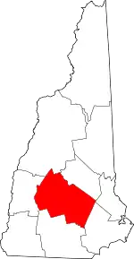 Map of New Hampshire highlighting Merrimack County | |
| Towns | ||
| CDPs | ||
| Other unincorporated communities | ||
| Footnotes | ‡This populated place also has portions in an adjacent county or counties | |
| ||