Webster, New Hampshire
Webster is a town in Merrimack County, New Hampshire, United States. The population was 1,872 at the 2010 census.[1]
Webster, New Hampshire | |
|---|---|
 | |
 Location in Merrimack County and the state of New Hampshire. | |
| Coordinates: 43°19′44″N 71°43′04″W | |
| Country | United States |
| State | New Hampshire |
| County | Merrimack |
| Incorporated | 1860 |
| Villages | Webster Swetts Mills |
| Government | |
| • Select Board | Christine L. Schadler, Chair Bianca Acebron Peco David Hemenway |
| • Town Administrator | Leslie M. Palmer |
| Area | |
| • Total | 28.6 sq mi (74.0 km2) |
| • Land | 27.9 sq mi (72.3 km2) |
| • Water | 0.7 sq mi (1.7 km2) 2.31% |
| Elevation | 682 ft (208 m) |
| Population (2010) | |
| • Total | 1,872 |
| • Density | 65/sq mi (25/km2) |
| Time zone | UTC-5 (Eastern) |
| • Summer (DST) | UTC-4 (Eastern) |
| ZIP code | 03303 |
| Area code(s) | 603 |
| FIPS code | 33-80020 |
| GNIS feature ID | 0873750 |
| Website | www |
History
A part of Boscawen until 1860, the town takes its name from American statesman Daniel Webster.[2]
Geography
According to the United States Census Bureau, the town has a total area of 28.6 square miles (74 km2), of which 27.9 sq mi (72 km2) is land and 0.7 sq mi (1.8 km2) is water, comprising 2.31% of the town. The highest point in Webster is 870 feet (270 m) above sea level, on an unnamed summit near the center of town that overlooks the eastern shore of Lake Winnepocket.
Demographics
| Historical population | |||
|---|---|---|---|
| Census | Pop. | %± | |
| 1870 | 689 | — | |
| 1880 | 647 | −6.1% | |
| 1890 | 564 | −12.8% | |
| 1900 | 496 | −12.1% | |
| 1910 | 445 | −10.3% | |
| 1920 | 334 | −24.9% | |
| 1930 | 360 | 7.8% | |
| 1940 | 351 | −2.5% | |
| 1950 | 386 | 10.0% | |
| 1960 | 457 | 18.4% | |
| 1970 | 680 | 48.8% | |
| 1980 | 1,095 | 61.0% | |
| 1990 | 1,405 | 28.3% | |
| 2000 | 1,579 | 12.4% | |
| 2010 | 1,872 | 18.6% | |
| 2017 (est.) | 1,917 | [3] | 2.4% |
| U.S. Decennial Census[4] | |||
At the 2000 census there were 1,579 people, 581 households, and 464 families living in the town. The population density was 56.6 people per square mile (21.9/km2). There were 672 housing units at an average density of 24.1 per square mile (9.3/km2). The racial makeup of the town was 98.86% White, 0.06% African American, 0.06% Native American, 0.38% Asian, 0.06% from other races, and 0.57% from two or more races. Hispanic or Latino of any race were 0.13%.[5]
Of the 581 households 34.9% had children under the age of 18 living with them, 68.3% were married couples living together, 7.4% had a female householder with no husband present, and 20.1% were non-families. 14.5% of households were one person and 4.6% were one person aged 65 or older. The average household size was 2.71 and the average family size was 2.99.
The age distribution was 25.8% under the age of 18, 5.3% from 18 to 24, 31.7% from 25 to 44, 27.9% from 45 to 64, and 9.2% 65 or older. The median age was 39 years. For every 100 females, there were 94.0 males. For every 100 females age 18 and over, there were 93.2 males.
The median household income was $54,052 and the median family income was $57,396. Males had a median income of $35,449 versus $24,250 for females. The per capita income for the town was $20,852. About 3.6% of families and 5.0% of the population were below the poverty line, including 5.0% of those under age 18 and 5.4% of those age 65 or over.
References
- United States Census Bureau, U.S. Census website, 2010 Census figures. Retrieved March 23, 2011.
- History of Boscawen and Webster
- "Annual Estimates of the Resident Population: April 1, 2010 to July 1, 2017 (PEPANNRES): Minor Civil Divisions – New Hampshire". Archived from the original on February 13, 2020. Retrieved November 15, 2018.
- "Census of Population and Housing". Census.gov. Retrieved June 4, 2016.
- "U.S. Census website". United States Census Bureau. Retrieved 2008-01-31.
External links
Places adjacent to Webster, New Hampshire | |
|---|---|
Municipalities and communities of Merrimack County, New Hampshire, United States | ||
|---|---|---|
| Cities | 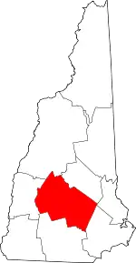 Map of New Hampshire highlighting Merrimack County | |
| Towns | ||
| CDPs | ||
| Other unincorporated communities | ||
| Footnotes | ‡This populated place also has portions in an adjacent county or counties | |
| ||
| Authority control |
|---|