Warner, New Hampshire
Warner is a town in Merrimack County, New Hampshire, United States. The population was 2,833 at the 2010 census.[1] The town is home to Magdalen College of the Liberal Arts, Rollins State Park and Mount Kearsarge State Forest.
Warner, New Hampshire | |
|---|---|
 Statue of Walter Harriman in the town center | |
 Seal | |
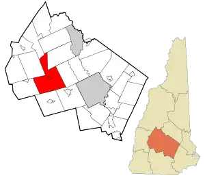 Location in Merrimack County and the state of New Hampshire. | |
| Coordinates: 43°16′49″N 71°48′57″W | |
| Country | United States |
| State | New Hampshire |
| County | Merrimack |
| Incorporated | 1774 |
| Villages | Warner Davisville Lower Village Melvin Mills Waterloo |
| Government | |
| • Board of Selectmen | Clyde Carson, Chair Judy Newman-Rogers Jonathan Lord |
| • Town Administrator | Diane Ricciardelli |
| Area | |
| • Total | 55.9 sq mi (144.8 km2) |
| • Land | 55.6 sq mi (144.1 km2) |
| • Water | 0.2 sq mi (0.6 km2) 0.43% |
| Elevation | 446 ft (136 m) |
| Population (2010) | |
| • Total | 2,833 |
| • Density | 51/sq mi (20/km2) |
| Time zone | UTC-5 (Eastern) |
| • Summer (DST) | UTC-4 (Eastern) |
| ZIP code | 03278 |
| Area code(s) | 603 |
| FIPS code | 33-78580 |
| GNIS feature ID | 0873745 |
| Website | www |
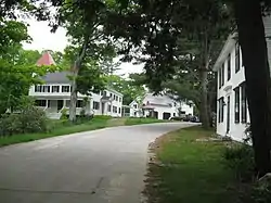
The town's central settlement, where 444 people resided at the 2010 census,[2] is defined as the Warner census-designated place (CDP), and is located along New Hampshire Route 103 and the Warner River. The town also includes the villages of Davisville, Lower Village, Melvin Mills, and Waterloo.
History
The town was granted in 1735 as "Number One" by Massachusetts Governor Jonathan Belcher to petitioners largely from Amesbury, Massachusetts. Called "New Amesbury", it was part of a line of settlements running between the Merrimack and Connecticut rivers intended to help defend Massachusetts against New France's predations. It was regranted by the Masonian Proprietors in 1749, when it was settled with four houses and a sawmill. Called "Jennesstown", it was abandoned and destroyed during the French and Indian War. The town was granted again in 1767 to Jonathan Barnard and others, who called it "Amesbury". But on September 3, 1774, it was incorporated as "Warner", named after Jonathan Warner, a leading Portsmouth citizen, namesake of the Warner House and relative of Governor John Wentworth. It was one of the last towns established under English provincial rule prior to the Revolution.[3]
Warner developed into a prosperous farming community which produced meats, dairy goods, vegetables, hay and apples. The Warner River and its tributaries provided water power for mills, which in 1832 included twelve sawmills, 6 gristmills, a paper mill and two clothing factories. By 1858, there was also a cabinet manufacturer and bottle manufacturer. In 1885, industries included a bedstead factory, chain factory, woolen cloth factory, iron foundry, tannery and glove manufacturer. On September 9, 1821, the town was hit by a tornado. It leveled houses and forests in a 16-to-18-mile (26 to 29 km) swath of destruction beginning west of Lake Sunapee, through New London and Sutton, over the southwest spur of Mount Kearsarge and ending at the Webster line. The storm killed four people in Warner, seriously injured others and destroyed considerable property.[4]
Each October, on Columbus Day weekend, Warner hosts the annual Fall Foliage Festival, attracting thousands of people from all over New England and beyond.
 Pillsbury Free Library c. 1908
 Main Street c. 1908
 Boston & Maine Railroad depot in 1909
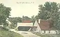 Old Mill in 1907
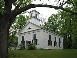

Geography
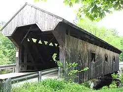
According to the United States Census Bureau, the town has a total area of 55.9 square miles (144.8 km2), of which 55.7 sq mi (144.3 km2) is land and 0.2 sq mi (0.5 km2) is water, comprising 0.43% of the town. Warner is drained by the Lane and Warner rivers. Two covered bridges span the Warner River: the Dalton Bridge and the Waterloo Bridge.
Mount Kearsarge, elevation 2,937 feet (895 m) above sea level, located in the extreme north of the town, is the highest point in Warner. Two state parks are located on the mountain: Rollins State Park in Warner and Winslow State Park in Wilmot. Mount Kearsarge is a popular hiking destination, due both to its bare, rocky summit, and to the fact that a paved road climbs from Rollins State Park to within a half mile of the summit. The peak is the highest point along the 75-mile (121 km) Sunapee-Ragged-Kearsarge Greenway, a hiking trail which links 10 towns and encircles the Lake Sunapee region of western New Hampshire.
The town is served by Interstate 89 and New Hampshire Route 103. State routes 114 and 127 cross the extreme southwestern and southeastern corners of the town, respectively.
Demographics
| Historical population | |||
|---|---|---|---|
| Census | Pop. | %± | |
| 1790 | 863 | — | |
| 1800 | 1,569 | 81.8% | |
| 1810 | 1,838 | 17.1% | |
| 1820 | 2,246 | 22.2% | |
| 1830 | 2,222 | −1.1% | |
| 1840 | 2,159 | −2.8% | |
| 1850 | 2,038 | −5.6% | |
| 1860 | 1,970 | −3.3% | |
| 1870 | 1,667 | −15.4% | |
| 1880 | 1,537 | −7.8% | |
| 1890 | 1,383 | −10.0% | |
| 1900 | 1,358 | −1.8% | |
| 1910 | 1,226 | −9.7% | |
| 1920 | 1,051 | −14.3% | |
| 1930 | 1,062 | 1.0% | |
| 1940 | 1,113 | 4.8% | |
| 1950 | 1,080 | −3.0% | |
| 1960 | 1,004 | −7.0% | |
| 1970 | 1,441 | 43.5% | |
| 1980 | 1,963 | 36.2% | |
| 1990 | 2,250 | 14.6% | |
| 2000 | 2,760 | 22.7% | |
| 2010 | 2,833 | 2.6% | |
| 2017 (est.) | 2,912 | [5] | 2.8% |
| U.S. Decennial Census[6] | |||
As of the census of 2010, there were 2,833 people, 1,116 households, and 752 families residing in the town. The population density was 51.0 people per square mile (19.7/km2). There were 1,228 housing units at an average density of 24.4 per square mile (8.5/km2). The racial makeup of the town was 97.9% White, 0.4% African American, 0.4% Native American, 0.2% Asian, 0.3% some other race, and 0.8% from two or more races. Hispanic or Latino of any race were 1.8% of the population.[1]
There were 1,116 households, out of which 29.0% had children under the age of 18 living with them, 56.1% were headed by married couples living together, 7.0% had a female householder with no husband present, and 32.6% were non-families. 29.0% of all households were made up of individuals, and 8.8% were someone living alone who was 65 years of age or older. The average household size was 2.44, and the average family size was 2.92.[1]
In the town, the population was spread out, with 20.6% under the age of 18, 8.1% from 18 to 24, 22.1% from 25 to 44, 34.2% from 45 to 64, and 15.0% who were 65 years of age or older. The median age was 44.5 years. For every 100 females, there were 97.4 males. For every 100 females age 18 and over, there were 95.3 males.[1]
For the period 2007–11, the estimated median annual income for a household in the town was $58,221, and the median income for a family was $65,167. Male full-time workers had a median income of $51,404 versus $34,154 for females. The per capita income for the town was $28,159. About 4.3% of the population were below the poverty line.[7]
The Warner Area Farmers' Market, held on Saturday mornings on Main Street, serves as a community gathering place.
Government
In the New Hampshire Senate, Warner is in the 15th District, represented by Democrat Dan Feltes. On the New Hampshire Executive Council, Warner is in the 2nd District, represented by Democrat Andru Volinsky. In the United States House of Representatives, Warner is in New Hampshire's 2nd congressional district, represented by Democrat Ann McLane Kuster.
Sites of interest

Notable people
- Caroline Gardner Bartlett, music educator and relief worker in World War I
- Adelaide George Bennett (1848–1911), poet and botanist
- David Carroll, naturalist, author, MacArthur Foundation Fellow
- H. Maria George Colby, author, fashion editor
- William C. Dowling, scholar, author. and Guggenheim Fellow
- David Elliott, children's author
- Gordon Enoch Gates, zoologist and Guggenheim Fellow
- Henry Gilmore, businessman and state senator for Massachusetts
- Walter Harriman, 31st governor of New Hampshire
- Amanda Bartlett Harris, author and literary critic
- Maxine Kumin, poet[8]
- Nehemiah G. Ordway, seventh governor of Dakota Territory
- Jacob Osgood, leader of sectarian religious group
- Charles Alfred Pillsbury, industrialist
- John Sargent Pillsbury, businessman and the eighth governor of Minnesota
- Nellie George Stearns (1855–1936), artist and teacher of art
References
- "Profile of General Population and Housing Characteristics: 2010 Demographic Profile Data (DP-1): Warner town, Merrimack County, New Hampshire". U.S. Census Bureau, American Factfinder. Archived from the original on February 10, 2020. Retrieved March 15, 2013.
- "Profile of General Population and Housing Characteristics: 2010 Demographic Profile Data (DP-1): Warner CDP, New Hampshire". U.S. Census Bureau, American Factfinder. Archived from the original on February 10, 2020. Retrieved March 15, 2013.
- Coolidge, Austin J.; John B. Mansfield (1859). A History and Description of New England. Boston, Massachusetts: A.J. Coolidge. pp. 671–672.
coolidge mansfield history description new england 1859.
- Jacob B. Moore, Historical Sketches of the Town of Warner, New Hampshire, Mason P. Tilden, Warner, New Hampshire, 1832
- "Annual Estimates of the Resident Population: April 1, 2010 to July 1, 2017 (PEPANNRES): Minor Civil Divisions – New Hampshire". Archived from the original on February 13, 2020. Retrieved November 15, 2018.
- "Census of Population and Housing". Census.gov. Retrieved June 4, 2016.
- "Selected Economic Characteristics: 2007-2011 American Community Survey 5-Year Estimates (DP03): Warner town, Merrimack County, New Hampshire". U.S. Census Bureau, American Factfinder. Archived from the original on February 10, 2020. Retrieved March 15, 2013.
- "Maxine Kumin: 1925-2014". Arts & Artists. New Hampshire State Council on the Arts. Retrieved September 8, 2020.
External links
- Town of Warner official website
- Pillsbury Free Library
- Warner Fall Foliage Festival
- Kearsarge Trail Snails Snowmobile Club
- New Hampshire Economic and Labor Market Information Bureau Profile
- Magdalen College of the Liberal Arts
Places adjacent to Warner, New Hampshire | |
|---|---|
Municipalities and communities of Merrimack County, New Hampshire, United States | ||
|---|---|---|
| Cities | 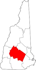 Map of New Hampshire highlighting Merrimack County | |
| Towns | ||
| CDPs | ||
| Other unincorporated communities | ||
| Footnotes | ‡This populated place also has portions in an adjacent county or counties | |
| ||
| Authority control |
|---|