Pembroke, New Hampshire
Pembroke is a town in Merrimack County, New Hampshire, United States. The population was 7,115 at the 2010 census.[1] Pembroke includes part of the village of Suncook. The center of population of New Hampshire is located in Pembroke.[2]
Pembroke, New Hampshire | |
|---|---|
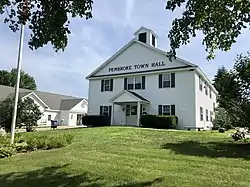 Town Hall in 2020 | |
 Seal | |
| Motto(s): "Prosper in Pembroke" | |
 Location in Merrimack County and the state of New Hampshire. | |
| Coordinates: 43°08′48″N 71°27′27″W | |
| Country | United States |
| State | New Hampshire |
| County | Merrimack |
| Incorporated | 1759 |
| Villages | Pembroke North Pembroke Pembroke Hill Suncook (part) |
| Government | |
| • Board of Selectmen | Ann Bond, Chair Sandy Goulet Mike Crockwell Richard Bean Karen Yeaton |
| • Town Administrator | David Jodoin |
| Area | |
| • Total | 23.0 sq mi (59.5 km2) |
| • Land | 22.8 sq mi (59.1 km2) |
| • Water | 0.2 sq mi (0.4 km2) 0.70% |
| Elevation | 413 ft (126 m) |
| Population (2010) | |
| • Total | 7,115 |
| • Density | 310/sq mi (120/km2) |
| Time zone | UTC-5 (Eastern) |
| • Summer (DST) | UTC-4 (Eastern) |
| ZIP code | 03275 |
| Area code(s) | 603 |
| FIPS code | 33-60020 |
| GNIS feature ID | 0873696 |
| Website | www |
History
First granted in 1728, the town was known as "Lovewell's Town", in honor of Captain John Lovewell, who built the stockade at Ossipee. Shortly afterward, the town took the name of "Suncook", the Pennacook Abenaki name for the river flowing through the area. When the town was incorporated in 1759 by Colonial Governor Benning Wentworth, it was given the name "Pembroke" in honor of Henry Herbert, ninth Earl of Pembroke in southern Wales.
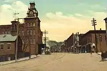
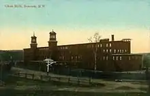
Pembroke's early history is reflected in the various mills of the downtown area, located to use water power from the Suncook River. The better-known mills were the Pembroke Mills, Webster Manufacturing and China Manufacturing, all producing print cloth. Pembroke industries included brickmaking, with bricks manufactured from clay along the Merrimack River. In 1852, the Concord and Portsmouth Railroad established a station in Pembroke.
Geography
According to the United States Census Bureau, the town has a total area of 23.0 square miles (59.6 km2), of which 22.8 sq mi (59.1 km2) is land and 0.2 sq mi (0.5 km2) is water, comprising 0.70% of the town. Pembroke is drained by the Suncook, Soucook and Merrimack rivers. The highest point in town, Plausawa Hill, elevation 1,000 feet (305 m) above sea level, is in the north.
Adjacent municipalities
- Loudon (north)
- Chichester (north)
- Epsom (east)
- Allenstown (southeast)
- Bow (southwest)
- Concord (northwest)
Demographics
| Historical population | |||
|---|---|---|---|
| Census | Pop. | %± | |
| 1790 | 956 | — | |
| 1800 | 982 | 2.7% | |
| 1810 | 1,153 | 17.4% | |
| 1820 | 1,256 | 8.9% | |
| 1830 | 1,312 | 4.5% | |
| 1840 | 1,336 | 1.8% | |
| 1850 | 1,733 | 29.7% | |
| 1860 | 1,313 | −24.2% | |
| 1870 | 2,518 | 91.8% | |
| 1880 | 2,797 | 11.1% | |
| 1890 | 3,172 | 13.4% | |
| 1900 | 3,183 | 0.3% | |
| 1910 | 3,062 | −3.8% | |
| 1920 | 2,563 | −16.3% | |
| 1930 | 2,792 | 8.9% | |
| 1940 | 2,769 | −0.8% | |
| 1950 | 3,094 | 11.7% | |
| 1960 | 3,514 | 13.6% | |
| 1970 | 4,261 | 21.3% | |
| 1980 | 4,861 | 14.1% | |
| 1990 | 6,561 | 35.0% | |
| 2000 | 6,897 | 5.1% | |
| 2010 | 7,115 | 3.2% | |
| 2017 (est.) | 7,154 | [3] | 0.5% |
| U.S. Decennial Census[4] | |||

As of the census[5] of 2000, there were 6,897 people, 2,661 households, and 1,876 families residing in the town. The population density was 302.1 people per square mile (116.6/km2). There were 2,734 housing units at an average density of 119.8 per square mile (46.2/km2). The racial makeup of the town was 97.84% White, 0.38% African American, 0.26% Native American, 0.38% Asian, 0.03% from other races, and 1.12% from two or more races. Hispanic or Latino of any race were 0.43% of the population.
There were 2,661 households, out of which 37.3% had children under the age of 18 living with them, 55.7% were married couples living together, 10.4% had a female householder with no husband present, and 29.5% were non-families. 23.0% of all households were made up of individuals, and 7.3% had someone living alone who was 65 years of age or older. The average household size was 2.59 and the average family size was 3.06.
In the town, the population was spread out, with 26.9% under the age of 18, 6.9% from 18 to 24, 33.1% from 25 to 44, 23.1% from 45 to 64, and 9.9% who were 65 years of age or older. The median age was 37 years. For every 100 females, there were 98.3 males. For every 100 females age 18 and over, there were 94.5 males.
The median income for a household in the town was $49,494, and the median income for a family was $57,106. Males had a median income of $37,786 versus $26,781 for females. The per capita income for the town was $20,800. About 3.0% of families and 5.4% of the population were below the poverty line, including 3.2% of those under age 18 and 10.9% of those age 65 or over.
Transportation
Three New Hampshire State Routes, one Interstate Highway, and three U.S. Routes cross Pembroke.
- NH 9 crosses the narrow salient at the northern edge of town between Concord in the west and Chichester in the east. It merges with US 4/US 202 at the end of the I-393 freeway just before entering Chichester. It is known locally as Loudon Road.
- NH 28 crosses a small portion of northeastern Pembroke. It enters from Allenstown in the south, follows the Suncook River along its western bank, then crosses into Epsom in the north. It is locally known as Pinewood Road.
- NH 106 begins at an interchange with US 3 between the village of Suncook and the Concord line. It heads north and crosses the Soucook River into Concord.
- US 3 enters from the south in the village of Suncook from Allenstown after crossing the Suncook River. It follows Pembroke Street to the northwest before crossing the Soucook River into Concord.
- US 4 and US 202 enter the narrow salient at the northern edge of town from Concord along the I-393 freeway, then merge with NH 9 before the three concurrent routes enter Chichester.
- I-393 terminates shortly after entering the narrow salient at the northern edge of town from Concord. The roadway continues on as NH 9/US 4/US 202.
Education
There are currently three public schools in Pembroke. The Hill School is attended by children in Kindergarten through fourth grades. Three Rivers School, named after the three rivers that form most of the borders of the town, was built in the early 1990s and contains fifth through eighth grade. The town's high school is Pembroke Academy, founded in 1818 as a private school. The school today is public and takes students from Pembroke and from the neighboring towns of Allenstown, Epsom, Chichester, and historically, Deerfield. With approximately 1,000 students, the school is Class I in athletics, the second-highest class, and the mascot of the school is the Spartan.
Notable people
- Robert E. Cochran (1810–1836), Alamo defender, born in Pembroke; Cochran County, Texas, is named after him[6][7]
- Byron M. Cutcheon (1836-1908), American Civil War officer and U.S. Congressman[8]
- Brian Foster (b. 1987), ice hockey goaltender, plays for the Stockton Thunder[9]
- Thomas W. Knox (1835-1896), journalist and author, New York Herald correspondent during the American Civil War[9]
- Megan McTavish (b. 1949), soap opera writer; Daytime Emmy winner (All My Children, Guiding Light, One Life to Live, General Hospital)[9]
- Caleb Scofield, bassist and singer, played for alternative metal band Cave In[9]
- Plausawa (c.1700–1754), Native American; Plausawa Hill and a golf course are named after him[10]
- Caleb Stark (1759–1838), Revolutionary War era officer; son of Gen. John Stark[11]
References
- United States Census Bureau, U.S. Census website, 2010 Census figures. Retrieved March 23, 2011.
- "State Centers of Population by Year: 2010". U.S. Census Bureau. Retrieved January 7, 2015.
- "Annual Estimates of the Resident Population: April 1, 2010 to July 1, 2017 (PEPANNRES): Minor Civil Divisions – New Hampshire". Archived from the original on February 13, 2020. Retrieved November 15, 2018.
- "Census of Population and Housing". Census.gov. Retrieved June 4, 2016.
- "U.S. Census website". United States Census Bureau. Retrieved 2008-01-31.
- "2011 marks 175th anniversary of famed Alamo siege". The Telegraph. Retrieved March 21, 2014.
- "COCHRAN, ROBERT E." Texas State Historical Association. Retrieved March 21, 2014.
- "CUTCHEON, Byron M., (1836 - 1908)". Biographical Directory of the United States Congress. Retrieved March 21, 2014.
- "Pembroke, New Hampshire". City-Data.com. Retrieved March 21, 2014.
- Browne, George Waldo (1908). Granite State Magazine, Volume 5. Granite State Publishing Company. p. 298.
- Carter, Nathan Franklin and Fowler, Trueworthy Ladd (1895). History of Pembroke, N. H.: 1730-1895, Volume 1. Republican Press Association. p. 352.
External links
| Wikimedia Commons has media related to Pembroke, New Hampshire. |
- Town of Pembroke official website
- New Hampshire Economic and Labor Market Information Bureau Profile
- School Administrative Unit #53
Places adjacent to Pembroke, New Hampshire | ||||||||||
|---|---|---|---|---|---|---|---|---|---|---|
| ||||||||||
Municipalities and communities of Merrimack County, New Hampshire, United States | ||
|---|---|---|
| Cities | 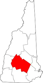 Map of New Hampshire highlighting Merrimack County | |
| Towns | ||
| CDPs | ||
| Other unincorporated communities | ||
| Footnotes | ‡This populated place also has portions in an adjacent county or counties | |
| ||
| Authority control |
|---|