Clairville, Toronto
Clairville (or sometimes, and more properly, Claireville) is a neighbourhood and former hamlet in the city of Toronto, Ontario, Canada. It is located in the northwest corner of Toronto, in the former city of Etobicoke. Today Clairville is almost wholly industrial/commercial.
Clairville | |
|---|---|
Neighbourhood | |
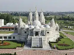 BAPS Shri Swaminarayan Mandir near the West Humber River | |
.png.webp) | |
| Coordinates: 43°45′00″N 79°38′20″W | |
| Country | |
| Province | |
| City | |
| Community | Etobicoke-York |
| Established | 1849 (Subdivision) |
| Changed Municipality | 1998 Toronto from Etobicoke |
| Government | |
| • MP | Kirsty Duncan (Etobicoke North) |
| • MPP | Shafiq Qaadri (Etobicoke North) |
| • Councillor | Vincent Crisanti (Ward 1 Etobicoke North) |
History
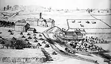
The original hamlet was established in 1850 at the five-point intersection of Albion Road, Indian Line (later incorporated into Highway 50 and Highway 427), and Steeles Avenue. It was built on a land owned by Jean du Petit Pont de la Haye (1799-1872), a French teacher at Upper Canada College. He developed the community on his estate which he named after his daughter Claire Elizabeth (later Berthon b. 1831-d. 1903).[1] A private street was built diagonally across northern Etobicoke as a shortcut to Albion Township through Toronto Gore Township (now part of Caledon and Brampton), with a toll at Clairville. The road was originally named Clairville but was also called the Albion Road (the current name for the street).[2]
Development
A flood control dam was built on the West Branch of the Humber River immediately south of the village in 1957, creating the Clairville reservoir and the establishment of Claireville Conservation Area. Clairville began to lose it's rural character as suburban industrial development encroached. In the mid-1980, Albion Road and Steeles Avenue were realigned, bypassing the community. In the 1970s Highway 427 was built along the Indian Line alignment along the southwestern edge of the neighbourhood and in the 1990s was extended to Highway 407 when that toll road was built just to the north. This combined with the existing rail lines and proximity to Pearson Airport make the area prime industrial land. Today, some of original residential homes have disappeared in the Toronto section of Clairville and replaced with warehousing and open storage / trucking uses, and most of the remaining homes are no longer used as residences.
Clairville has today unofficially expanded into Brampton, with the portion west of an abandoned portion of former Indian Line and Highway 427 being in Brampton. Like in Toronto, the Brampton Portion largely consists of residential subdivisions, north of Queen Street. The Indian Line Campground is situated in Malton (Mississauga), near the south end.
The area is close to the large south Asian communities of Rexdale, as well as Brampton and Malton outside the city. This accessible area with large cheap lots has become home to several Hindu temples, most notably the BAPS Shri Swaminarayan Mandir Toronto.
Education
The Toronto District School Board operates an elementary school. Claireville Junior School and provides a space for approximately 375 students.[3] Under the Toronto District School Board, this public elementary school that begins from Junior Kindergarten to Grade 5, engages also with the parents/guardians of students, as well as with the community through many partnerships such as Holiday Food Drive with the Daily Bread, Co-op Student placements from local high schools, Teacher Candidates from York University, University of Toronto and other Faculties of Education.
References
- "Dwellers on City's edge pull up roots." Peter Kuitenbrouwer. National Post. Jul 5, 2006. pg. A.6
- Villages of Etobicoke, 'Clairville' by Mae Snider Hames; Argyle Print. Co., Weston Ont., Pgs 9 - 13
- "Claireville Junior School". www.tdsb.on.ca. Retrieved 2021-01-31.
Places adjacent to Clairville, Toronto | ||||||||||
|---|---|---|---|---|---|---|---|---|---|---|
| ||||||||||