Woodbridge, Ontario
Woodbridge is a large suburban community in Vaughan, Ontario, Canada, along the city's border with Toronto. Situated west of Highway 400 and east of Highway 50, north of Steeles Avenue, and generally south of Major Mackenzie Drive West. It was once an independent town before being amalgamated with nearby communities to form the city in 1971. Its traditional downtown core is the Woodbridge Avenue stretch between Islington Avenue and Kipling Avenue north of Highway 407.
Woodbridge | |
|---|---|
Suburban district | |
 Woodbridge within Vaughan | |
| Coordinates: 43°47′06.23″N 079°35′35.95″W | |
| Country | Canada |
| Province | Ontario |
| Regional Municipality | York |
| City | Vaughan |
| Settled | 1802 |
| Incorporated | 1882 (Village) |
| Changed Municipality | 1971 York Region from York County |
| Annexed | 1971 into Vaughan (as Town) 1990 (as City) |
| Government | |
| • MP | Francesco Sorbara (Vaughan—Woodbridge) |
| • MPP | Michael Tibollo (Vaughan-Woodbridge) |
| • Councillors | Tony Carella (Ward 2) Rosanna DeFrancesca (Ward 3) |
| Area | |
| • Total | 79.84 km2 (30.83 sq mi) |
| Population (2016)[1] | |
| • Total | 105,228 |
| • Density | 1,318.0/km2 (3,414/sq mi) |
| Forward Sortation Area | L3L, L4H, L4L |
History
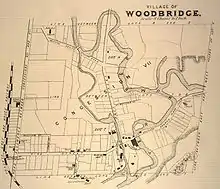


The community had its origins with the British Crown granting the west half of lots six and seven, concession 7 of Vaughan Township to Jacob Philips and Hugh Cameron in 1802.[2] During the early half the 19th century, a school was built on Vaughan's eighth concession; and a flour mill and store flourished at Pine Grove, which is among the oldest areas of the city. A scattering of houses arose around Smith's mill (presently Hayhoe Mills on Pine Grove). Smith's mill later became known as Smithsville, but was eventually incorporated into the town of Woodbridge. A similar settlement, known as Brownsville, came into being around a mill run by John Brown on the Humber River on what is today Wallace Street in today's downtown Woodbridge business section. Woodbridge proper, however, did not begin to take the form of a settlement or village until the arrival of Rowland Burr in 1837.[2]
The settlement's name was changed to Woodbridge in 1855 because there was already a settlement named Burrwick. The name was taken from the wooden bridge that crossed the Humber River as an entry point into town. The historic bridge was located close to what is today Islington Avenue and Langstaff Road, on Langstaff looking north. A replica bridge circa 1930 made out of concrete remains close to the original bridge location and is accessible from Boyd Park and to a city maintenance facility. The bridge has been rebuilt as of 2016 and instead of being wooden, it is now made of steel.
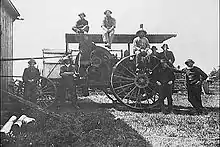
A major industry over time, Abell Agricultural Works opened in 1862 and had 200 employees by 1874, making steam-powered agriculture equipment. The Toronto, Grey and Bruce Railway arrived from Weston in 1870. This line was constructed as a narrow gauge railway through Caledon and completed to Owen Sound in 1873. Owing to financial difficulty, it was operated by the Grand Trunk Railway until 1883, when it was leased to the Canadian Pacific Railway. Conversion to standard gauge required realigning some of the track curves, particularly around Woodbridge. In 1908 this line was linked to the transcontinental route through Sudbury, while the original route between Bolton and Orangeville, was abandoned in 1934.[3]
By 1880, the settlement had two general stores, a carriage works, two churches, a school, two hotels, a library, two newspaper and a post office. By 1882, Woodbridge had over a thousand residents and was incorporated as a village.[3]
Woodbridge was also served by a branch of the Toronto Suburban Railway until the 1930s. The radial railway from Weston came in along the west side of the river, north of Humber Summit, after descending from its route along Albion Road and Kipling Avenue.[3]
Construction of Highway 7 began in the 1920s, passing south of the business section and through an underpass of the Canadian Pacific. The original railway bridge spanned the valley of the Humber River, while construction of Highway 407 has undermined the banks of the river on both sides, requiring a third overpass for the railway. As Woodbridge is on the Humber floodplain, Hurricane Hazel in 1954 devastated the community as the river swelled from its usual width of 20 m (66 ft) at its narrowest point to 107 m (351 ft), and left hundreds homeless and nine dead.[4] During much of this time, the land surrounding much of Woodbridge was used for farming. Slowly the area became populated with custom country houses.
In the 1950s, Woodbridge experienced growth from suburban Toronto houses. Many Italians that settled in Downtown Toronto, such as in Little Italy, moved to the suburbs, in particular Woodbridge.[5] The suburban expansion began east of the Humber and East Humber and to the northeast. Prior to the expansion, the urban area was up to Kipling Avenue and to the Humber. It later expanded in the west up to Martin Grove Road with a north to south width of about 800 m in the 1960s and to the north and portions of the northeast of Langstaff Road. It later expanded north in the 1970s and the 1980s. A drive-in theatre was situated at Highway 27 and Langstaff near Martin Grove Road. Operating from 1967 to 1997, it was torn down in 1998 for residential houses.
The housing developments in the west expanded north to Langstaff and in the central part of Woodbridge including a part that transformed older stores into smaller units of housing in the early-1980s and west to Highway 27 in the late-1980s and in 1992. The houses expanded north to 400 m south of Rutherford Road in the 1980s and east up to Weston Road from Highway 7 to 400 m south of Rutherford Road and south to 200 m north of the present-day Highway 407. The Industrial areas began appearing first to the west and then to the southwest and to the east.
The housing developments in mid-1990s expanded Martin Grove Road northward. Woodbridge Highlands was formed in the northwest, east of Highway 27 in the 1990s. In 1994 housing developments reached to Rutherford and continued until 1996 except for the northeast and the southeastern part. The condominiums began construction and now appear between Woodbridge Avenue and the Humber. Sonoma Heights at Islington and Rutherford and the Vellore area at Weston and Rutherford have been developed. The Vellore area includes Vellore Village developed by builders such as Greenpark Homes, Aspen Ridge Homes and Remington Homes. The Vellore Woods area was developed by Arista Homes and Fieldgate Homes. Development in the west end of Woodbridge then followed with Weston Rd and Rutherford becoming a major focal point for the building of additional residential units stretching north to Major Mackenzie. Land on both sides of Weston Road to Major Mackenzie were completely filled in.
Woodbridge Avenue between Islington Avenue and Kipling Avenue was once home to some of the historical buildings from the late 19th century in addition to newer 1920s-1960s buildings, but is rapidly being reconstructed. Two examples of a historic buildings include a Tinsmith Shop and Masonic Lodge (circa 1850) and the Burwick family home (from 1844 on Pine Street) that were moved to Black Creek Pioneer Village.[6] Market Lane remains the commercial hub of this area, with several other shops and stores lining Woodbridge Avenue.
Woodbridge was chosen as the new location for a research based mental health facility, the OCD and Anxiety Clinic of Ontario. First of its kind, it offers specialized psychological care by offering case by case care, as opposed to a volume patient care model.[7][8]
An F2 tornado tore through the city of Vaughan during the Southern Ontario Tornado Outbreak on August 20, 2009. The tornado also ripped up trees, flipped cars, and left thousands of people without power. No one was killed.[9][10]
Geography
Situated in hilly terrain of the Humber River Valley, historic Woodbridge rests at an average elevation of 200 metres between Highway 27 and Pine Valley Drive.[11] The terrain can be described as a series of rolling hills and valleys. There are numerous valley intersections that demonstrate the geography of the area, notably Highway 7 and Islington and Highway 27 and Rutherford.
The area was mainly farmland before the onset of suburbanization in the 1970s, but the residential communities are interspersed with forests along the Humber River and its eastern branch. Today, much of the area is residential with commercial and industrial properties to the south, close to Steeles Avenue and to the east near Pine Valley Drive.

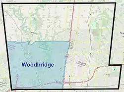
The area commonly considered to be Woodbridge today covers a very large portion (roughly one-third) of Vaughan, and is usually seen as being bounded by Highway 50 or Highway 27 to the west, Steeles Avenue to the south, Highway 400 to the east, and Major Mackenzie Drive to the north.[12]
Climate
Woodbridge has a humid continental climate (Köppen climate classification Dfb), with warm, humid summers and cold, snowy winters. Woodbridge winters feature cold snaps where maximum temperatures remain below −10 °C (14 °F), often made to feel colder by wind chill. Accumulating snow can fall any time from October until April. Summer in Woodbridge is characterized by long stretches of humid weather. Spring and autumn are transitional seasons, with generally mild or cool temperatures and alternating dry and wet periods. According to the USDA plant hardiness level, Woodbridge is 5a.
| Climate data for Vaughan 1981–2010 (Woodbridge) | |||||||||||||
|---|---|---|---|---|---|---|---|---|---|---|---|---|---|
| Month | Jan | Feb | Mar | Apr | May | Jun | Jul | Aug | Sep | Oct | Nov | Dec | Year |
| Record high °C (°F) | 17.0 (62.6) |
15.5 (59.9) |
26.5 (79.7) |
31.5 (88.7) |
33.0 (91.4) |
36.0 (96.8) |
39.0 (102.2) |
37.2 (99.0) |
36.1 (97.0) |
30.6 (87.1) |
25.0 (77.0) |
19.5 (67.1) |
39.0 (102.2) |
| Average high °C (°F) | −2.5 (27.5) |
−0.5 (31.1) |
4.3 (39.7) |
12.0 (53.6) |
18.8 (65.8) |
24.1 (75.4) |
26.9 (80.4) |
25.4 (77.7) |
20.9 (69.6) |
13.9 (57.0) |
6.9 (44.4) |
0.8 (33.4) |
12.6 (54.7) |
| Daily mean °C (°F) | −6.6 (20.1) |
−4.8 (23.4) |
−0.4 (31.3) |
6.6 (43.9) |
12.9 (55.2) |
18.1 (64.6) |
20.8 (69.4) |
19.6 (67.3) |
15.4 (59.7) |
9.0 (48.2) |
3.1 (37.6) |
−2.8 (27.0) |
7.6 (45.7) |
| Average low °C (°F) | −10.7 (12.7) |
−9.2 (15.4) |
−5.2 (22.6) |
1.2 (34.2) |
6.8 (44.2) |
12.0 (53.6) |
14.7 (58.5) |
13.8 (56.8) |
9.8 (49.6) |
4.0 (39.2) |
−0.8 (30.6) |
−6.4 (20.5) |
2.5 (36.5) |
| Record low °C (°F) | −34.5 (−30.1) |
−30.0 (−22.0) |
−29.4 (−20.9) |
−17.2 (1.0) |
−6.7 (19.9) |
−1.7 (28.9) |
2.8 (37.0) |
−0.6 (30.9) |
−5.0 (23.0) |
−11.7 (10.9) |
−18.3 (−0.9) |
−30.0 (−22.0) |
−34.5 (−30.1) |
| Average precipitation mm (inches) | 50.3 (1.98) |
44.2 (1.74) |
49.2 (1.94) |
63.3 (2.49) |
79.1 (3.11) |
76.3 (3.00) |
70.4 (2.77) |
80.4 (3.17) |
84.6 (3.33) |
66.5 (2.62) |
78.3 (3.08) |
57.4 (2.26) |
799.8 (31.49) |
| Average rainfall mm (inches) | 20.4 (0.80) |
23.2 (0.91) |
31.4 (1.24) |
59.6 (2.35) |
79.1 (3.11) |
76.3 (3.00) |
70.4 (2.77) |
80.4 (3.17) |
84.6 (3.33) |
66.0 (2.60) |
71.1 (2.80) |
34.6 (1.36) |
697.0 (27.44) |
| Average snowfall cm (inches) | 29.9 (11.8) |
21.1 (8.3) |
17.8 (7.0) |
3.7 (1.5) |
0.0 (0.0) |
0.0 (0.0) |
0.0 (0.0) |
0.0 (0.0) |
0.0 (0.0) |
0.45 (0.18) |
7.2 (2.8) |
22.8 (9.0) |
102.8 (40.5) |
| Average precipitation days (≥ 0.2 mm) | 13.5 | 10.3 | 10.7 | 11.8 | 12.0 | 10.8 | 9.5 | 9.6 | 10.6 | 12.7 | 13.1 | 12.8 | 137.4 |
| Average rainy days (≥ 0.2 mm) | 4.2 | 4.4 | 6.4 | 10.7 | 12.0 | 10.8 | 9.5 | 9.6 | 10.6 | 12.6 | 11.1 | 6.5 | 108.3 |
| Average snowy days (≥ 0.2 cm) | 10.2 | 6.8 | 5.1 | 1.5 | 0.0 | 0.0 | 0.0 | 0.0 | 0.0 | 0.23 | 3.0 | 7.5 | 34.3 |
| Source: Environment Canada[13] | |||||||||||||
Demographics
As of the 2016 census, the top three ethnic groups in Woodbridge are Italian (53.5%; the highest concentration in Canada), East Indian (7.0%), Canadian (6.5%).[1]
Attractions

Greenspace
Woodbridge is home to two natural preserves along the Humber River:
- Boyd Conservation Area
- Kortright Centre for Conservation
- Doctors McLean District Park
- Rainbow Creek Park
- Woodbridge Fairgrounds
- Fundale Park
- Maxey Park
Sites of interest
- Market Lane
- Memorial Hill with a tower
- Pierre Berton Library
- Boyd Conservation Area
- Kortright Centre
Education
- Blue Willow Public School
- Dayley's Mills Public School
- Padre Dave Cheapola
- Emily Carr Secondary School
- Father Bressani Catholic High School
- Fossil Hill Public School
- Elders Mills Public School
- Holy Cross Catholic Academy
- Immaculate Conception Catholic Elementary School
- Lorna Jackson Public School
- North Hill Private School
- Our Lady of Fatima Catholic Elementary School
- Pine Grove Public School
- San Marco Catholic Elementary School
- St. Agnes Of Assisi Elementary School
- St. Andrew Catholic Elementary School
- St. Angela Merici Catholic Elementary School
- St. Catherine of Siena Catholic Elementary School
- St. Clare Catholic Elementary School
- St. Clement Catholic Elementary School
- St. Francis of Assisi Catholic Elementary School
- St. Gabriel the Archangel Catholic Elementary School
- St. Gregory the Great Academy
- St. Jean de Brebeuf Catholic High School
- St. Emily Catholic Elementary School
- St. John Bosco Catholic Elementary School
- St. Margaret Mary Catholic Elementary School
- St. Padre Pio Catholic Elementary School
- St. Peter Catholic Elementary School
- St. Stephen Catholic Elementary School
- Tommy Douglas Secondary School
- Toronto District Christian High School
- Vellore Woods Public School
- Woodbridge College
- Woodbridge Montessori School (Private Elementary)
- Woodbridge Public School
- Glenn Gould Public School
- St.Michael the Archangel Catholic Elementary
Notable people
- Elizabeth Arden, founder of cosmetic company of the same name
- Robert Barbieri, professional rugby player
- Mark Bocek, UFC fighter
- Jesse Carere, actor
- Anthony Cirelli, hockey player
- Andrew Cogliano, NHL player
- Frank Corrado, NHL player
- Chris DiDomenico, NHL player
- Natalie Di Luccio, international multilingual singer
- Sergio Di Zio, actor
- Steve Eminger, AHL player
- Danny Fernandes, singer
- Mike Harris, 22nd Premier of Ontario
- Mike Liambas, NHL player
- Victor Mete, hockey player
- Steve Nease, cartoonist
- Michael Petrasso, soccer player
- Dina Pugliese, television personality
- Marco Reda, professional soccer player
- David Rocco, actor and television cooking show host
- Vince Rocco, ice hockey player
- Arthur Evans Snell, 10th Canadian Surgeon General
- Marco Terminesi, soccer player
- Stephen Lecce, Minister of Education (raised in Woodbridge).
In popular culture
The song "The Woodbridge Dog Disaster" by Canadian folk singer Stan Rogers, detailing a fictional occurrence in the community, was recorded in the 1970s.
References
| Wikimedia Commons has media related to Woodbridge, Ontario. |
- "Census Profile, 2016 Census Woodbridge-Vaughan". Statistics Canada. 2016. Retrieved 4 December 2018.
- City of Vaughan Archives, http://www.city.vaughan.on.ca/tourism/history/woodbridge.cfm Accessed 4 January 2008
- "History of Woodbridge". City of Vaughan. Retrieved 19 February 2020.
- http://www.hurricanehazel.ca/ssi/about_community.shtml
- "The littlest Little Italy slowly fades away". theglobeandmail.com. 26 August 2005.
- Black Creek Pioneer Village Buildings, "Archived copy". Archived from the original on 12 April 2010. Retrieved 2 January 2010.CS1 maint: archived copy as title (link) Accessed 16 January 2010
- "'OCD and Anxiety Clinic Ontario' by Healthcare in Canada, mayor says". Vaughan Citizen. 20 August 2009. Retrieved 21 August 2009.
- "Relief in Vaughan". Ocdontario.com. Retrieved 2 January 2012.
- "'Miracle no one killed' by Vaughan tornado, mayor says". Vaughan Citizen. 20 August 2009. Retrieved 21 August 2009.
- "Relief and disbelief in Vaughan". Cnews.canoe.ca. Retrieved 2 January 2012.
- "Woodbridge, ON". Community Demographics. Industry Canada. Archived from the original on 17 June 2009. Retrieved 12 April 2006.
- http://www.elections.ca/res/cir/maps2/mapprov.asp?map=35111
- "Woodbridge, Ontario". Canadian Climate Normals 1981–2010. Environment Canada. Retrieved 17 December 2013.
Places adjacent to Woodbridge, Ontario | |
|---|---|
| Communities |
| ||||||||||
|---|---|---|---|---|---|---|---|---|---|---|---|
| Culture and services | |||||||||||
| Education |
| ||||||||||
| Government |
| ||||||||||
| Transportation | |||||||||||
| Sport | |||||||||||
| |||||||||||
Largest city: Toronto | ||
| Regions | 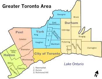 | |
| Cities | ||
| Towns | ||
| Townships | ||
| Municipalities | ||