Colorado Basin, Argentina
The Colorado Basin (Spanish: Cuenca del Colorado) is a sedimentary basin located in northeastern Argentina. The basin stretches across an area of approximately 180,000 square kilometres (69,000 sq mi), of which 37,000 square kilometres (14,000 sq mi) onshore in the southern Buenos Aires Province and the easternmost Río Negro Province extending offshore in the South Atlantic Ocean.
| Colorado Basin | |
|---|---|
| Cuenca del Colorado | |
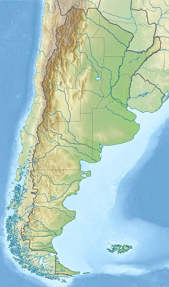 Location of the basin in Argentina | |
| Coordinates | 41°30′S 61°00′W |
| Etymology | Colorado River |
| Country | |
| State(s) | Buenos Aires & Río Negro Provinces |
| Cities | Bahía Blanca, Viedma |
| Characteristics | |
| On/Offshore | Both |
| Boundaries | Ventania High (N) Argentina Basin (E) Rawson/Río Negro High (S) San Rafael Block (W) |
| Part of | South Atlantic rift basins |
| Area | ~180,000 km2 (69,000 sq mi) |
| Hydrology | |
| Sea(s) | South Atlantic |
| River(s) | Río Negro & Colorado Rivers |
| Geology | |
| Basin type | Passive margin on rift basin |
| Plate | South American |
| Orogeny | Break-up of Pangea |
| Age | Early Cretaceous-Quaternary |
| Stratigraphy | Stratigraphy |
| Field(s) | none |
The basin comprises a sedimentary succession dating from the Permian (pre-rift stage) and Early Cretaceous (rift stage) to the Quaternary, representing the passive margin tectonic phase of the basin history. The Mesozoic rifting in the basin resulted from the break-up of Pangea and the formation of the South Atlantic. Long hiatuses exist in the succession.
The basin is of paleontological significance for hosting fossiliferous stratigraphic units dating to the Late Miocene. The Arroyo Chasicó Formation defines the Chasicoan South American land mammal age and contains a rich mammal and other vertebrate fauna. The contemporaneous Cerro Azul Formation has provided fossil rodents, armadillos and opossums. The Middle to Late Miocene Gran Bajo del Gualicho Formation contains vertebrate fossils of the cetacean Preaulophyseter gualichensis. The Río Negro Formation has provided fossils of the glyptodont Plohophorus figuratus. The Permian succession in the basin has provided flora microfossils.
Contrasting with the South Atlantic passive margin basins to the north (Santos Basin in southern Brazil) and south; Golfo San Jorge and Austral Basins, the Colorado Basin does not produce hydrocarbons. Exploration for petroleum started in the 1940 with the drilling of two onshore wells and several onshore and offshore wells have been drilled in the 1960s, 1970s and 1990s. The main source rocks are found in the Permian succession, with reservoir rocks the Colorado Formation. Seals are provided by the Early Paleocene Pedro Luro Formation.
Description
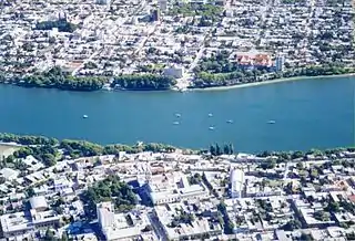
The Colorado Basin stretches across an approximate area of 180,000 square kilometres (69,000 sq mi) with about 37,000 square kilometres (14,000 sq mi) onshore, underlying the southernmost Buenos Aires Province and the southeasternmost Río Negro Province. Cities inside the basin are Bahía Blanca and Carmen de Patagones in Buenos Aires Province and Viedma in Río Negro Province, the earliest founded city in Patagonia. The onshore part of the basin is crossed by the eponymous Colorado and Río Negro rivers. Surrounding the Río Negro, many salt lakes are present in the basin.[1]
Some authors group the basin together with the Claromecó Basin to the north.[2] The offshore part of the Colorado Basin laterally correlates with and gradually ranges into the sub-parallel Salado Basin and the deeper offshore Argentina Basin.[3][4] The offshore extension of the basin into neighboring basins led to different definitions of its area, some authors use a surface area of 125,000 square kilometres (48,000 sq mi).[5]
The Colorado Basin is bound to the north by the Ventania High,[6] Sierra de la Ventana,[7] or Sierras Australes,[2] separating the basin from the Claromecó Basin, and to the south by the Rawson,[8] or Río Negro High.[9] In the northwest, the basin grades into the Macachín Basin and the western boundary is formed by the San Rafael Block.[9]
Basin evolution
The basin started forming in the Middle to Late Jurassic with the break-up of Pangea and the formation of the Southern Atlantic.[10] The main rifting took place in the Early Cretaceous.[5] The pre-rift sequence of the basin comprises the Pennsylvanian Lolén Formation of the Ventana Group,[11] and the Sauce Grande, Piedra Azul, Bonete and Tunas Formations of the Pillahuincó Group,[2] dating to the Permian.[12] During the late Paleozoic, the Colorado Basin was located in the south polar region, causing a sequence of glacial deposits in the basin. These deposits were mostly sourced from the African basin, the Karoo and Kalahari Basins. The Early Permian sediments are characterized by the presence of diamictites. A transgression in the Permian led to the deposition of the Piedra Azul Formation.[13] The succession contains several hiatuses, dating to the Triassic and Early Jurassic, Albian and Paleogene.[14]
The early Mesozoic succession is missing, and the main rifting phase happened in the Barremian and Aptian, around 120 million years ago, represented in the Fortín Formation.[15] The post-rift sag stage dates to the early Late Cretaceous leading to the deposition of the alluvial and fluvial sediments of the Colorado Formation.[14] The drift stage is represented by the Pedro Luro Formation.[14] The later Cenozoic succession is characteristic of a terrestrial passive margin setting and comprises the Paleocene Elvira,[14] Middle Miocene Barranca Final Formation,[16] and the Middle to Late Miocene Gran Bajo de Gualicho Formation.[17] This formation in most of the basin is overlain by the Río Negro Formation.[18] The Late Miocene succession in the westernmost area of the basin is represented by the Arroyo Chasicó and eolian Cerro Azul Formations,[19] cropping out in the northern onshore part of the basin.[20] This sequence is covered by the Late Miocene to Early Pliocene eolian and fluvial Río Negro Formation,[21][22] outcropping in a thin band along the eponymous river.[1]
Stratigraphy
| Age | Group | Formation | Environment | Tectonic regime | Maximum thickness | Petroleum geology | Notes |
|---|---|---|---|---|---|---|---|
| Quaternary | alluvium | Passive margin | |||||
| Early Pliocene | Río Negro | Eolian & fluvial | 480 m (1,570 ft) | [21][22] | |||
| Late Miocene | |||||||
| Chasicoan-Huayquerian | Cerro Azul | Eolian | 180 m (590 ft) | [19][23] | |||
| Chasicoan | Arroyo Chasicó | Floodplain | [24] | ||||
| Mayoan | Gran Bajo de Gualicho | Shallow marine | 57 m (187 ft) | [17] | |||
| Laventan | |||||||
| Colloncuran | |||||||
| Friasian | |||||||
| Santacrucian | |||||||
| Mid Miocene | Barranca Final | Marine | 300 m (980 ft) | [16] | |||
| Oligocene | Hiatus | ||||||
| Late Eocene | |||||||
| Middle Eocene | Elvira | [14] | |||||
| Early Eocene | Hiatus | ||||||
| Late Paleocene | |||||||
| Early Paleocene | Pedro Luro | Drift | Seal | [14] | |||
| Maastrichtian | Hiatus | ||||||
| Campanian | Colorado | Alluvial & fluvial | Sag | Reservoir | [14] | ||
| Santonian | |||||||
| Coniacian | |||||||
| Turonian | |||||||
| Cenomanian | |||||||
| Albian | Hiatus | ||||||
| Aptian | Fortín | Syn-rift | Reservoir Source | [15] | |||
| Barremian | |||||||
| Middle Jurassic | Hiatus | ||||||
| Early Jurassic | |||||||
| Triassic | |||||||
| Late Permian | Pillahuincó | Tunas | Pre-rift | 1,500 m (4,900 ft) | Source | [2] | |
| Early Permian | Bonete | Source | [2] | ||||
| Piedra Azul | [2] | ||||||
| Sauce Grande | [2] | ||||||
| Pennsylvanian | Ventana | Lolén | Basement | [11] | |||
Paleontological significance
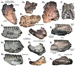
The Miocene formations cropping out onshore have provided a rich mammal fauna. The Arroyo Chasicó Formation is the defining formation for the Late Miocene Chasicoan South American land mammal age, ranging from 10 to 9 million years ago.[25] The formation contains many mammal species, birds and reptiles.[26] The Cerro Azul Formation contains fossils of the rodents Chasichimys bonaerense,[27] Neocavia pampeana,[28] Reigechimys plesiodon and R. simplex,[29] the armadillos Chasicotatus ameghinoi,[23] and Macrochorobates scalabrinii,[27] and the opossum Zygolestes tatei,[30] among other mammals. The Río Negro Formation has provided fossils of the glyptodont Plohophorus figuratus.[31]
The marine Gran Bajo de Gualicho Formation contains many bivalve, gastropod and echinoid fossils,[32] and the cetacean Preaulophyseter gualichensis.[33] The Eocene succession in boreholes of the basin has provided many species of dinoflagellates,[34] and in the Permian sequence 131 species of spores, algae, funghi and pollen were registered.[35]
Petroleum exploration
Contrary to other Southern Atlantic marginal basins, as the Golfo San Jorge and Austral Basins to the south, and Santos Basin of Brazil to the north, the Colorado Basin is not producing hydrocarbons. The first wells in the northern onshore part of the basin were drilled in 1946 (Pedro Luro-1) and 1948 (Ombucta-1) by YPF. Another phase of onshore exploration happened in the 1960s, with seven wells drilled by Shell.[36] Offshore drilling started in 1970 by Hunt Oil and after seismic acquisition in the 1970s by YPF,[37] some wells were drilled in 1977 by the same company. Renewed exploration started in the mid-1990s with several wells drilled by Union Texas and Shell.[38] The offshore Cruz del Sur x-1 well provided oil shows of 39° API.[39]
References
- Geologic Map Hojas 4163-II/IV & I/III, 2006
- Balarino, 2012, p.344
- Pucci, 2006, p.17
- ENARSA, s.a., p.3
- ENARSA, s.a., p.2
- Daners et al., 2016, p.285
- Balarino, 2009, p.20
- ENARSA, s.a., p.1
- Barredo & Stinco, 2010, p.60
- Geologic Map Hojas 3963-III & IV, 2009, p.42
- Balarino, 2009, p.24
- Balarino, 2009, p.22
- Balarino, 2009, p.23
- ENARSA, s.a., p.4
- Barredo & Stinco, 2010, p.52
- Geologic Map Hojas 3963-III & IV, 2009, p.39
- Reichler, 2010, p.192
- Reichler, 2010, p.183
- Visconti et al., 2010, p.259
- Geologic Map Hojas 3963-III & IV, 2009, p.5
- Pérez, 2010, p.7
- Geologic Map Hojas 3963-III & IV, 2009, p.8
- Scillato Yané et al., 2010, p.51
- Zárate et al., 2007
- Chasicoan at Fossilworks.org
- Arroyo Chasicó at Fossilworks.org
- Verzi et al., 2008
- Madozzo Jaén et al., 2018, p.250
- Sostillo et al., 2014
- Goin et al., 2000, p.108
- Punta Bermeja at Fossilworks.org
- Reichler, 2010, pp.191-192
- Buono, 2013, p.36
- Daners et al., 2016, p.293
- Balarino, 2012, p.343
- Rossello, 2016, p.175
- ENARSA, s.a., p.8
- ENARSA, s.a., p.5
- Pucci, 2006, p.18
Bibliography
- General
- Balarino, M. Lucía. 2012. Palinología del Pérmico de la Cuenca Claromecó-Colorado, Argentina. Ameghiniana 49. 343–364. Accessed 2019-03-06.
- Balarino, M. Lucía. 2009. Palinoestratigrafía del Paleozoico Superior de la Cuenca Colorado, República Argentina, y su correlación con áreas relacionadas (PhD thesis), 1–566. Universidad Nacional de La Plata.
- Barredo, Silvia P., and Luis P. Stinco. 2010. Geodinámica de las cuencas sedimentarias: su importancia en la localización de sistemas petroleros en la Argentina. Petrotecnia Abril. 48–68. Accessed 2019-03-06.
- Daners, Gloria; G. Raquel Guerstein; Cecilia R. Amenábar, and Ethel Morales. 2016. Dinoflagelados del Eoceno Medio a Superior de las Cuencas Punta del Este y Colorado, latitudes medias del Atlántico Sudoccidental. Revista Brasileira de Paleontologia 19. 283–302. Accessed 2019-03-06.
- ENARSA, .. s.a. Geología de la Cuenca del Colorado, 1–13. Energía Argentina S.A. Accessed 2019-03-06.
- Pucci, Juan Carlos. 2006. Situación de las cuencas marinas de la República Argentina. Petrotecnia Abril. 16–26. Accessed 2019-03-06.
- Rossello, Eduardo A. 2016. Tectosedimentary characterization of the oil producer basins in Argentina, 1–192. GFZ Potsdam. Accessed 2019-03-06.
- Geologic maps
- Etcheverría, Mariela P.; Alicia Folguera; Fernando Miranda; Abel J. Faroux; Pablo R. Getino, and Marcelo Raúl Dalponte. 2009. Hojas Geológicas 3963-III y IV Colonia Juliá y Echarren y Pedro Luro, 1–61. SEGEMAR. Accessed 2019-03-06.
- Etcheverría, Mariela P.; Alicia Folguera; Carlos Nelson Dal Molin; Marcelo Raúl Dalponte; Georgina Ferro, and Mario Franchi. 2006. Hojas Geológicas 4163 - II/IV y I/III Viedma y General Conesa, 1. SEGEMAR. Accessed 2019-03-06.
- Arroyo Chasicó Formation
- González Ruiz, Laureano R.; Gustavo J. Scillato Yané; Cecilia M. Krmpotic, and Alfredo A. Carlini. 2012. A new species of Peltephilidae (Mammalia: Xenarthra: Cingulata) from the late Miocene (Chasicoan SALMA) of Argentina. Zootaxa 3359. 55–64. Accessed 2019-02-15.
- Pérez, María Encarnación; Cecilia M. Deschamps, and María Guiomar Vucetich. 2018. Diversity, phylogeny and biogeography of the South American 'cardiomyine' rodents (Hystricognathi, Cavioidea) with a description of two new species. Papers in Palaeontology 4. 1–19. Accessed 2019-02-12.
- Rasia, Luciano L., and Adriana M. Candela. 2016. Lagostomus telenkechanum, sp. nov., a new lagostomine rodent (Caviomorpha, Chinchillidae) from the Arroyo Chasicó Formation (late Miocene; Buenos Aires Province, Argentina). Journal of Vertebrate Paleontology 37. e1239205. Accessed 2019-02-12.
- Zárate, Marcelo A.; Peter H. Schultz; Adriana Blasi; Clifford Heil; John King, and Willis Hames. 2007. Geology and geochronology of type Chasicoan (late Miocene) mammal-bearing deposits of Buenos Aires (Argentina). Journal of South American Earth Sciences 23. 81–90. Accessed 2019-03-06.
- Cerro Azul Formation
- Goin, F.J.; C. Montalvo, and G. Visconti. 2000. Los marsupiales (Mammalia) del Mioceno superior de la Formación Cerro Azul (Provincia de La Pampa, Argentina). Estudios Geológicos 56. 101–126. Accessed 2017-08-15.
- Madozzo Jaén, M. Carolina; M. Encarnación Pérez; Claudia I. Montalvo, and Rodrigo L. Tomassini. 2018. Systematic review of Neocavia from the Neogene of Argentina: Phylogenetic and evolutionary implications. Acta Palaeontologica Polonica 63. 241–260. Accessed 2019-03-08.
- Scillato Yané, Gustavo Juan; Cecilia Mariana Krmpotic, and Graciela Irene Esteban. 2010. The species of genus Chasicotatus Scillato-Yané (Eutatini, Dasypodidae). Revista Mexicana de Ciencias Geológicas 27. 43–55. Accessed 2019-03-08.
- Sostillo, Renata; Claudia I. Montalvo, and Diego H. Verzi. 2014. A new species of Reigechimys (Rodentia, Echimyidae) from the Late Miocene of central Argentina and the evolutionary pattern of the lineage. Ameghiniana 51. 284–294. Accessed 2019-02-12.
- Verzi, D.H.; C.I. Montalvo, and C.M. Deschamps. 2008. Biostratigraphy and biochronology of the Late Miocene of central Argentina: Evidence from rodents and taphonomy. Geobios 41. 145–155. Accessed 2019-03-06.
- Visconti, Graciela; Ricardo N. Melchor; Claudia I. Montalvo; Aldo M. Umazano, and Elena E. De Elorriaga. 2010. Análisis litoestratigráfico de la Formación Cerro Azul (Mioceno Superior) en la Provincia de La Pampa. Revista de la Asociación Geológica Argentina 67. 257–265. Accessed 2019-03-06.
- Gran Bajo del Gualicho Formation
- Buono, Mónica R. 2013. Evolución de los Balaenidae (Mammalia, Cetacea, Mysticeti) del Mioceno de Patagonia: Sistemática, Filogenia y Aspectos Paleobiológicos, 1–232. Universidad Nacional de La Plata. Accessed 2019-03-06.
- Reichler, Valeria A. 2010. Estratigrafía y paleontología del Cenozoico marino del Gran Bajo y Salinas del Gualicho, Argentina, y descripción de 17 especies nuevas. Andean Geology 31. 177–219. Accessed 2019-03-06.
- Río Negro Formation
- Pérez, Mariano. 2012. Análisis paleoambiental del miembro superior de la Formación Río Negro (Mioceno-Plioceno de Patagonia septentrional): un ejemplo de interacción fluvio-eólica compleja (BSc. thesis), 1–47. Universidad Nacional de La Pampa. Accessed 2018-09-10.
Sedimentary basins of Argentina | ||||||
|---|---|---|---|---|---|---|
| Onshore & offshore |
| | ||||
| Offshore |
| |||||
| Sources |
| |||||