Cottonwood, Minnesota
Cottonwood is a city in Lyon County, Minnesota, United States. The population was 1,212 at the 2010 census.[6]
Cottonwood, Minnesota | |
|---|---|
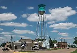 Cottonwood from County Highway 9 | |
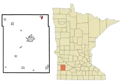 Location of Cottonwood, Minnesota | |
| Coordinates: 44°36′31″N 95°40′23″W | |
| Country | United States |
| State | Minnesota |
| County | Lyon |
| Government | |
| • Type | Mayor – Council |
| • Mayor | Corey Moseng |
| Area | |
| • Total | 1.00 sq mi (2.58 km2) |
| • Land | 1.00 sq mi (2.58 km2) |
| • Water | 0.00 sq mi (0.00 km2) |
| Elevation | 1,079 ft (329 m) |
| Population | |
| • Total | 1,212 |
| • Estimate (2019)[3] | 1,236 |
| • Density | 1,240.96/sq mi (479.12/km2) |
| Time zone | UTC-6 (Central (CST)) |
| • Summer (DST) | UTC-5 (CDT) |
| ZIP code | 56229 |
| Area code(s) | 507 |
| FIPS code | 27-13564[4] |
| GNIS feature ID | 0641528[5] |
| Website | www |
Geography
According to the United States Census Bureau, the city has a total area of 1.04 square miles (2.69 km2), all of it land.[7] Cottonwood is situated on the Eastern shore of Cottonwood Lake.
Minnesota State Highway 23 serves as a main route in the city.
In February 2008, a bus crash occurred in Cottonwood when a school bus carrying students from Lakeview Public Schools was struck by a driver who ran through a stop sign which caused the bus to fall onto a pickup killing 4 students and injuring 17 others.
Demographics
| Historical population | |||
|---|---|---|---|
| Census | Pop. | %± | |
| 1900 | 549 | — | |
| 1910 | 770 | 40.3% | |
| 1920 | 813 | 5.6% | |
| 1930 | 615 | −24.4% | |
| 1940 | 690 | 12.2% | |
| 1950 | 709 | 2.8% | |
| 1960 | 717 | 1.1% | |
| 1970 | 794 | 10.7% | |
| 1980 | 924 | 16.4% | |
| 1990 | 982 | 6.3% | |
| 2000 | 1,148 | 16.9% | |
| 2010 | 1,212 | 5.6% | |
| 2019 (est.) | 1,236 | [3] | 2.0% |
| U.S. Decennial Census[8] | |||
2010 census
As of the census[2] of 2010, there were 1,212 people, 504 households, and 331 families living in the city. The population density was 1,165.4 inhabitants per square mile (450.0/km2). There were 545 housing units at an average density of 524.0 per square mile (202.3/km2). The racial makeup of the city was 95.8% White, 0.3% African American, 0.5% Native American, 0.1% Asian, 2.5% from other races, and 0.8% from two or more races. Hispanic or Latino of any race were 4.7% of the population.
There were 504 households, of which 31.0% had children under the age of 18 living with them, 55.2% were married couples living together, 7.3% had a female householder with no husband present, 3.2% had a male householder with no wife present, and 34.3% were non-families. 29.0% of all households were made up of individuals, and 10.7% had someone living alone who was 65 years of age or older. The average household size was 2.39 and the average family size was 2.94.
The median age in the city was 38.8 years. 25.2% of residents were under the age of 18; 7.1% were between the ages of 18 and 24; 25.7% were from 25 to 44; 27% were from 45 to 64; and 15% were 65 years of age or older. The gender makeup of the city was 49.3% male and 50.7% female.
2000 census
As of the census[4] of 2000, there were 1,148 people, 452 households, and 319 families living in the city. The population density was 1,339.0 people per square mile (515.4/km2). There were 481 housing units at an average density of 561.0 per square mile (215.9/km2). The racial makeup of the city was 96.34% White, 0.09% African American, 0.26% Native American, 0.44% Asian, 2.53% from other races, and 0.35% from two or more races. Hispanic or Latino of any race were 2.26% of the population.
There were 452 households, out of which 38.5% had children under the age of 18 living with them, 60.2% were married couples living together, 7.3% had a female householder with no husband present, and 29.4% were non-families. 26.1% of all households were made up of individuals, and 11.1% had someone living alone who was 65 years of age or older. The average household size was 2.50 and the average family size was 3.03.
In the city, the population was spread out, with 29.2% under the age of 18, 8.1% from 18 to 24, 28.9% from 25 to 44, 18.1% from 45 to 64, and 15.7% who were 65 years of age or older. The median age was 35 years. For every 100 females, there were 107.2 males. For every 100 females age 18 and over, there were 92.7 males.
The median income for a household in the city was $39,792, and the median income for a family was $49,375. Males had a median income of $31,298 versus $20,795 for females. The per capita income for the city was $19,847. About 2.8% of families and 4.5% of the population were below the poverty line, including 4.6% of those under age 18 and 6.9% of those age 65 or over.
References
- "2019 U.S. Gazetteer Files". United States Census Bureau. Retrieved July 26, 2020.
- "U.S. Census website". United States Census Bureau. Retrieved 2012-11-13.
- "Population and Housing Unit Estimates". United States Census Bureau. May 24, 2020. Retrieved May 27, 2020.
- "U.S. Census website". United States Census Bureau. Retrieved 2008-01-31.
- "US Board on Geographic Names". United States Geological Survey. 2007-10-25. Retrieved 2008-01-31.
- "2010 Census Redistricting Data (Public Law 94-171) Summary File". American FactFinder. United States Census Bureau. Retrieved 27 April 2011.
- "US Gazetteer files 2010". United States Census Bureau. Archived from the original on 2012-07-02. Retrieved 2012-11-13.
- "Census of Population and Housing". Census.gov. Retrieved June 4, 2015.
External links
Municipalities and communities of Lyon County, Minnesota, United States | ||
|---|---|---|
| Cities |  Map of Minnesota highlighting Lyon County | |
| Townships | ||
| Unincorporated communities | ||
| ||
