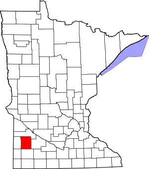
Lyon County, Minnesota
Lyon County is a county in the U.S. state of Minnesota. As of the 2010 United States Census, the population was 25,857.[1] Its county seat is Marshall.[2]
Lyon County | |
|---|---|
 Student Center at Southwest Minnesota State University. | |
 Location within the U.S. state of Minnesota | |
 Minnesota's location within the U.S. | |
| Coordinates: 44°25′N 95°50′W | |
| Country | |
| State | |
| Founded | March 6, 1868 March 2, 1869 |
| Named for | Nathaniel Lyon |
| Seat | Marshall |
| Largest city | Marshall |
| Area | |
| • Total | 722 sq mi (1,870 km2) |
| • Land | 715 sq mi (1,850 km2) |
| • Water | 7.1 sq mi (18 km2) 1.0%% |
| Population (2010) | |
| • Total | 25,857 |
| • Estimate (2019) | 25,474 |
| • Density | 36.1/sq mi (13.9/km2) |
| Time zone | UTC−6 (Central) |
| • Summer (DST) | UTC−5 (CDT) |
| Congressional district | 7th |
| Website | www |
Lyon County comprises the Marshall, MN Micropolitan Statistical Area.
History
The county was established by two acts of the Minnesota state legislature, dated March 6, 1868, and March 2, 1869. The county seat was designated as Marshall. The county was named for Nathaniel Lyon, an Army officer who served in the Dakota and Minnesota territories before being killed in the Civil War in 1861. He had achieved the rank of general by his death.[3][4] The county was much larger until an act passed on March 6, 1873, made the western 43% the new Lincoln County.
Geography
The Yellow Medicine River flows northeast through the upper portion of the county, the Redwood River flows northeast through the central part, and the Cottonwood River flows northeast through the lower part. The county's terrain consists of low rolling hills, etched by drainages and gullies.[5] It slopes to the north and east, with its highest point near its southwest corner, at 1,729' (527m) ASL.[6] The county has a total area of 722 square miles (1,870 km2), of which 715 square miles (1,850 km2) is land and 7.1 square miles (18 km2) (1.0%) is water.[7]
Lakes[5]
- Clear Lake
- Cottonwood Lake
- Dead Coon Lake
- East Twin Lake
- Goose Lake
- Island Lake
- Lady Slipper Lake
- Lake Marshall
- Lake of the Hill
- Lake Yankton
- Lone Tree Lake (part)
- Long Lake (part)
- McKay Lake
- North Twin Lake
- Rock Lake
- School Grove Lake (part)
- Sham Lake
- South Twin Lake
- West Twin Lake
- Wood Lake
Major highways
Airports[5]
- Southwest Minnesota Regional Airport (MML)
- Tracy Municipal Airport (TKC)
Adjacent counties
- Yellow Medicine County - north
- Redwood County - east
- Murray County - south
- Pipestone County - southwest
- Lincoln County - west
Protected areas[5]
- Camden State Park
- Gadwall State Wildlife Management Area
- Garvin State Park
- Grandview State Wildlife Management Area
- Greenhead State Wildlife Management Area
- Glynn Prairie Scientific and Natural Area
- Shelburne State Wildlife Management Area
- Vallers State Wildlife Management Area
Demographics
| Historical population | |||
|---|---|---|---|
| Census | Pop. | %± | |
| 1880 | 6,257 | — | |
| 1890 | 9,501 | 51.8% | |
| 1900 | 14,591 | 53.6% | |
| 1910 | 15,722 | 7.8% | |
| 1920 | 18,837 | 19.8% | |
| 1930 | 19,328 | 2.6% | |
| 1940 | 21,569 | 11.6% | |
| 1950 | 22,253 | 3.2% | |
| 1960 | 22,655 | 1.8% | |
| 1970 | 24,273 | 7.1% | |
| 1980 | 25,207 | 3.8% | |
| 1990 | 24,789 | −1.7% | |
| 2000 | 25,425 | 2.6% | |
| 2010 | 25,857 | 1.7% | |
| 2019 (est.) | 25,474 | [9] | −1.5% |
| US Decennial Census[10] 1790-1960[11] 1900-1990[12] 1990-2000[13] 2010-2019[1] | |||
2000 census
As of the 2000 United States Census,[14] there were 25,425 people, 9,715 households, and 6,334 families in the county. The population density was 35.6/sqmi (13.7/km2). There were 10,298 housing units at an average density of 14.4/sqmi (5.56/km2). The racial makeup of the county was 93.58% White, 1.49% Black or African American, 0.31% Native American, 1.67% Asian, 0.02% Pacific Islander, 1.89% from other races, and 1.04% from two or more races. 3.97% of the population were Hispanic or Latino of any race. 33.9% were of German, 15.5% Norwegian and 10.5% Belgian ancestry.
There were 9,715 households, out of which 33.00% had children under the age of 18 living with them, 55.10% were married couples living together, 7.10% had a female householder with no husband present, and 34.80% were non-families. 27.90% of all households were made up of individuals, and 12.40% had someone living alone who was 65 years of age or older. The average household size was 2.49 and the average family size was 3.09.
The county population contained 26.20% under the age of 18, 13.30% from 18 to 24, 26.50% from 25 to 44, 19.50% from 45 to 64, and 14.60% who were 65 years of age or older. The median age was 34 years. For every 100 females there were 95.70 males. For every 100 females age 18 and over, there were 93.20 males.
The median income for a household in the county was $38,996, and the median income for a family was $48,512. Males had a median income of $32,102 versus $21,445 for females. The per capita income for the county was $18,013. About 6.30% of families and 10.10% of the population were below the poverty line, including 10.00% of those under age 18 and 12.70% of those age 65 or over.
Communities
Cities
Unincorporated communities
Townships
- Amiret Township
- Clifton Township
- Coon Creek Township
- Custer Township
- Eidsvold Township
- Fairview Township
- Grandview Township
- Island Lake Township
- Lake Marshall Township
- Lucas Township
- Lynd Township
- Lyons Township
- Monroe Township
- Nordland Township
- Rock Lake Township
- Shelburne Township
- Sodus Township
- Stanley Township
- Vallers Township
- Westerheim Township
Politics
Lyon County has been a traditional Republican stronghold. In only one national election since 1980 has the county selected the Democratic Party candidate (as of 2016).
| Year | Republican | Democratic | Third parties |
|---|---|---|---|
| 2016 | 59.4% 7,256 | 31.3% 3,825 | 9.3% 1,134 |
| 2012 | 53.2% 6,594 | 44.1% 5,465 | 2.7% 329 |
| 2008 | 49.7% 6,315 | 48.1% 6,110 | 2.2% 283 |
| 2004 | 56.8% 7,203 | 41.8% 5,292 | 1.4% 178 |
| 2000 | 53.0% 6,087 | 41.2% 4,737 | 5.8% 665 |
| 1996 | 43.0% 4,932 | 44.1% 5,062 | 12.9% 1,483 |
| 1992 | 37.3% 4,591 | 36.4% 4,481 | 26.4% 3,252 |
| 1988 | 50.9% 5,969 | 48.2% 5,657 | 0.9% 110 |
| 1984 | 56.6% 7,170 | 42.6% 5,389 | 0.8% 100 |
| 1980 | 45.3% 5,852 | 43.6% 5,626 | 11.1% 1,433 |
| 1976 | 40.4% 5,036 | 57.2% 7,122 | 2.4% 300 |
| 1972 | 50.0% 5,820 | 48.3% 5,614 | 1.7% 196 |
| 1968 | 43.5% 4,331 | 53.4% 5,317 | 3.2% 318 |
| 1964 | 32.2% 3,165 | 67.7% 6,649 | 0.1% 8 |
| 1960 | 46.0% 4,740 | 53.9% 5,550 | 0.2% 15 |
| 1956 | 55.3% 5,188 | 44.6% 4,190 | 0.1% 8 |
| 1952 | 59.7% 6,015 | 40.0% 4,030 | 0.2% 24 |
| 1948 | 32.9% 3,054 | 66.2% 6,144 | 1.0% 88 |
| 1944 | 43.6% 3,617 | 55.9% 4,640 | 0.5% 38 |
| 1940 | 45.0% 4,305 | 54.7% 5,234 | 0.4% 36 |
| 1936 | 30.3% 2,551 | 61.3% 5,163 | 8.4% 710 |
| 1932 | 30.7% 2,264 | 67.6% 4,989 | 1.8% 130 |
| 1928 | 54.9% 4,058 | 44.3% 3,274 | 0.8% 56 |
| 1924 | 53.7% 3,519 | 5.1% 334 | 41.2% 2,700 |
| 1920 | 73.2% 4,557 | 19.8% 1,232 | 7.1% 440 |
| 1916 | 39.0% 1,389 | 53.1% 1,893 | 7.9% 282 |
| 1912 | 15.7% 460 | 36.3% 1,068 | 48.0% 1,411 |
| 1908 | 56.7% 1,618 | 36.6% 1,043 | 6.8% 193 |
| 1904 | 81.8% 2,394 | 11.3% 330 | 6.9% 202 |
| 1900 | 64.6% 1,844 | 30.8% 879 | 4.6% 131 |
| 1896 | 52.8% 1,623 | 44.0% 1,351 | 3.2% 98 |
| 1892 | 50.9% 1,068 | 23.2% 486 | 26.0% 545 |
References
- "State & County QuickFacts". United States Census Bureau. Archived from the original on June 7, 2011. Retrieved September 1, 2013.
- "Find a County". National Association of Counties. Retrieved June 7, 2011.
- Upham, Warren. Minnesota Geographical Names, p. 311 (1920). Accessed 13 March 2019
- Gannett, Henry (1905). The Origin of Certain Place Names in the United States. U.S. Government Printing Office. p. 193.
- Lyon County MN Google Maps (accessed March 13, 2019)
- ""Find an Altitude/Lyon County MN" Google Maps (accessed 13 March 2019)". Archived from the original on May 21, 2019. Retrieved March 13, 2019.
- "2010 Census Gazetteer Files". US Census Bureau. August 22, 2012. Archived from the original on September 21, 2013. Retrieved October 21, 2014.
- Nelson, Steven (2011). Savanna Soils of Minnesota. Minnesota: Self. pp. 69-70. ISBN 978-0-615-50320-2.
- "Population and Housing Unit Estimates". Retrieved March 26, 2020.
- "US Decennial Census". US Census Bureau. Retrieved October 21, 2014.
- "Historical Census Browser". University of Virginia Library. Retrieved October 21, 2014.
- "Population of Counties by Decennial Census: 1900 to 1990". US Census Bureau. Retrieved October 21, 2014.
- "Census 2000 PHC-T-4. Ranking Tables for Counties: 1990 and 2000" (PDF). US Census Bureau. Retrieved October 21, 2014.
- "U.S. Census website". US Census Bureau. Retrieved January 31, 2008.
- Leip, David. "Atlas of US Presidential Elections". uselectionatlas.org. Retrieved October 9, 2018.
External links
| Wikimedia Commons has media related to Lyon County, Minnesota. |
Places adjacent to Lyon County, Minnesota | ||||||||||
|---|---|---|---|---|---|---|---|---|---|---|
| ||||||||||
Municipalities and communities of Lyon County, Minnesota, United States | ||
|---|---|---|
| Cities | Map of Minnesota highlighting Lyon County | |
| Townships | ||
| Unincorporated communities | ||
| ||

| Authority control |
|---|