Crystal River (Colorado)
The Crystal River is a tributary of the Roaring Fork River, approximately 40 mi (64 km) long, in western Colorado in the United States. It drains a glacial valley, called the Coal Basin, south of Carbondale which was historically known as a center of coal mining in southwestern Colorado. It rises in northern Gunnison County in the Elk Mountains on the north side of Schofield Pass, passing through the ghost town of Crystal City, still inhabited by a few summer residents. It then flows north past Marble, then into Pitkin County past Redstone. It joins the Roaring Fork below Carbondale. State Highway 133 follows the river along much of its route north of Marble.
| Crystal River[1] | |
|---|---|
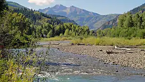 Crystal River at Redstone, with Chair Mountain in distance | |
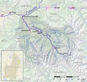 Map of Roaring Fork drainage basin, including the Crystal River | |
| Physical characteristics | |
| Source | |
| • location | Confluence of North Fork Crystal River and South Fork Crystal River |
| • coordinates | 39°03′32″N 107°06′15″W |
| Mouth | |
• location | Confluence with Roaring Fork River |
• coordinates | 39°25′07″N 107°14′10″W |
• elevation | 6,060 ft (1,850 m) |
| Basin features | |
| Progression | Roaring Fork—Colorado |
From Crystal City to Marble the river flows through the Crystal River Canyon, a narrow valley with numerous snowslide runs, rockfalls, and other hazardous terrain. Although it is locally known as a fishing and hiking attraction the unpaved and largely un-maintained mining road, designated Gunnison County Road 3 on Mapquest, is nearly impassable to vehicles other than ATVs and off-road motorcycles. A four-wheel-drive Jeep tour is operated out of Marble, but only operates during the summer when the road is not blocked by snow, mud, or rock slides.
References
- "Crystal River". Geographic Names Information System. United States Geological Survey. Retrieved 2011-01-27.
Neal, Roger (2002). Crystal... What Really Happened. Crystal Tale Books. ISBN 1-893270-12-2.
| Major cities |  | |
|---|---|---|
| Other communities | ||
| Near valley | ||
| Ski resorts | ||
| Bodies of water | ||
| Authority control |
|---|