Glenwood Springs, Colorado
The City of Glenwood Springs is the Home Rule Municipality that is the county seat of Garfield County, Colorado, United States.[10] Glenwood Springs is located at the confluence of the Roaring Fork River and the Colorado River, threading together the Roaring Fork Valley and a series of smaller towns up and down the Colorado River. As of the 2010 census it had a population of 9,614.[11]
Glenwood Springs, Colorado | |
|---|---|
Home Rule Municipality[1] | |
| City of Glenwood Springs[1] | |
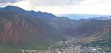
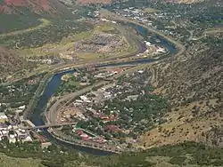 View of Glenwood Springs from Lookout Mountain. | |
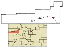 Location of the City of Glenwood Springs in Garfield County, Colorado. | |
 Glenwood Springs Location of the City of Glenwood Springs in the United States. | |
| Coordinates: 39°33′2″N 107°19′29″W | |
| Country | |
| State | |
| County | Garfield County[2] |
| City | Glenwood Springs[1] |
| Incorporated | September 4, 1885[3] |
| Government | |
| • Type | Home Rule Municipality[1] |
| Area | |
| • Total | 5.85 sq mi (15.14 km2) |
| • Land | 5.84 sq mi (15.12 km2) |
| • Water | 0.01 sq mi (0.02 km2) |
| Elevation | 5,761 ft (1,756 m) |
| Population (2010) | |
| • Total | 9,614 |
| • Estimate (2019)[6] | 9,930 |
| • Density | 1,701.51/sq mi (656.93/km2) |
| Demonym(s) | Glenwood Springer[7][8] |
| Time zone | UTC-7 (MST) |
| • Summer (DST) | UTC-6 (MDT) |
| ZIP codes[9] | 81601, 81602 (PO Box) |
| Area code(s) | 970 |
| FIPS code | 08-30780 |
| GNIS feature ID | 0204659 |
| Website | www |
Glenwood Springs is best known as a historic destination for vacationers with diverse natural amenities, most particularly the hot springs.
History
For centuries the area that is now Glenwood Springs was populated by indigenous people before the colonization of the Americas.[12] The oral history of the Kapuuta and Mouache bands recall that Glenwood Springs is located within the "traditional Nuuchiu tuvupu (The People's Land) of the Subuagan and Parianuche bands." Fred Conetah's History of the Northern Utes[13] states that the Yampa or White River bands used the area, which is now in the Ute ancestral jurisdiction.[14] The Utes were nomadic hunter-gatherers who seasonally used the natural hot springs in the area. The U.S. government surveyed the land in the mid-19th century, although they had no claim on the land. An 1868 treaty negotiated by the Tabeguache Ute Chief Ouray preserved the hunting grounds in the area of present day Glenwood Springs.[15]
For a short time in the 19th century, Glenwood Springs was known as "Defiance", a name sometimes still used by local teams or businesses. Defiance was established in 1883, as a camp of tents, saloons, and brothels with an increasing amount of cabins and lodging establishments. It was populated with gamblers, gunslingers, and prostitutes. Isaac Cooper was the founder of the town. His wife Sarah was having a hard time adjusting to the frontier life and, in an attempt to make her environment somewhat more comfortable, persuaded the founders to change the name to Glenwood Springs, Colorado, after her hometown of Glenwood, Iowa.[16]
Glenwood Springs, then a small encampment, was not the original county seat of Garfield County. Rather, a larger mining town that had been seeded with silver in order to attract miners on top of the Flat Tops mountains named Carbonate was the original county seat. Carbonate briefly had a post office, but the mail courier who won the contract to deliver mail to Carbonate found only one miner living there on his first delivery, which took 65km horizontally and 1.5km vertically. In the end, the courier paid the miner $100 in 1880's dollars to move out so that the post office could be closed and he wouldn't have to make the journey again. Carbonate remained the county seat for only four months before Glenwood Springs was selected by voters as the new location.[17]
The location of Glenwood Springs, and its railroad stop, established a center of commerce in the area. The city has seen well-known visitors, including President Teddy Roosevelt,[18][19] who spent a summer vacation living out of the historic Hotel Colorado. Doc Holliday, who was known for the O.K. Corral gunfight, spent the final months of his life in Glenwood Springs and is buried in the town's original Pioneer Cemetery above Bennett Avenue. Kid Curry is buried in the same location. The serial killer Ted Bundy was imprisoned in the Glenwood Springs jail until he escaped on the night of December 30, 1977, an escape which went undetected for 17 hours.[20]
Glenwood Springs was one of the first places in the United States to have electric lights. The original lighting was installed in 1897 inside of the Fairy Caves in Iron Mountain. Later, a dam was built in Glenwood Canyon, providing water for the Shoshone power plant. The plant began producing power on May 16, 1909, and retains the largest and oldest water rights to the Colorado River,[21] the "Shoshone Call",[22] which is now far more valuable for the protection of Colorado River water rather than the minimal electricity produced.[23]
In 2015, the town was named the "Most Vibrant Small Town Arts Environment in the United States"[24] by Southern Methodist University and the 5th Best Place to Live in America[25] by Outside magazine. It was named the "Most Fun Town in America" by Rand McNally and USA Today in 2011.[26]
Geography
Glenwood Springs is located in the narrow mountain valleys that host the confluence of the Colorado River and the Roaring Fork River. The surrounding terrain is steeply contoured on all sides, containing several caves.[27] The geology of the area includes geothermal activity, such as the local hot springs, but it is also evidenced through other features such as the Dotsero maar. Occasional proposals to leverage the geothermal energy for other purposes arise.[28] Glenwood Springs has experienced several mudslides throughout its history, a threat mitigated somewhat by public works.[29]
Glenwood Springs is one of the most walkable towns in America, a distinction that has been recognized by PBS[30] and Walking Magazine,[31] including in the Walking Town Hall of Fame.[32] Though the town's amenities and constrained geography make it a natural environment for pedestrians and cyclists; there are extensive trails running throughout[33] and around the city[34] resulted from planning efforts that began in the 1980s in response to congestion and traffic.[35]
Due to civic planning during the early years of the city, Glenwood Springs owns some senior water rights to tributaries of the Colorado River.[36] Despite little risk of water supply inadequacy, unlike most of the American West, conservation plans have been enacted anyway for largely environmental reasons. Supply is ample enough that the city has an incomplete understanding of its own water rights.[37] The town's drinking water is supplied primarily through senior rights to major watersheds in the Flat Tops Wilderness Area, and the tap water is generally of excellent quality.[38]
Mineral deposits exist further up the Crystal River and in the Roaring Fork area, and petroleum resources are ample in western Garfield County,[39] which brings tax revenue to Glenwood Springs. However, the town itself lies outside of the Colorado Mineral Belt, and there are no mineral or oil and gas sources near Glenwood Springs proper or its watersheds.[39] While the paucity of minerals and oil was disastrous for early miners hoping to strike it rich, modern Glenwood Springs has none of the typical Colorado mountain town legacy of resource extraction,[40] boasting pristine air,[41] water, and land.[42] Valley inversions and heavy traffic to Aspen can lead to air quality problems during exceptionally cold spells of winter.
According to the U.S. Census Bureau, Glenwood Springs has a total area of 5.7 square miles (14.7 km2), of which 0.01 square miles (0.02 km2), or 0.16%, is water.[11]
Climate
Glenwood Springs has a generally mild and semi-arid climate, much more consistently stable than that of the Front Range and most of Colorado, though still decidedly continental and prone to periods of extreme weather. Microclimates dominate Glenwood Springs, with areas close to the rivers often much more damp and cool than hillsides.
| Climate data for Glenwood Springs (1981–2010 normals, extremes 1893–present) | |||||||||||||
|---|---|---|---|---|---|---|---|---|---|---|---|---|---|
| Month | Jan | Feb | Mar | Apr | May | Jun | Jul | Aug | Sep | Oct | Nov | Dec | Year |
| Record high °F (°C) | 60 (16) |
67 (19) |
79 (26) |
88 (31) |
95 (35) |
102 (39) |
102 (39) |
100 (38) |
100 (38) |
88 (31) |
80 (27) |
65 (18) |
102 (39) |
| Average high °F (°C) | 35.5 (1.9) |
41.0 (5.0) |
51.5 (10.8) |
59.4 (15.2) |
69.8 (21.0) |
81.0 (27.2) |
87.3 (30.7) |
85.1 (29.5) |
76.2 (24.6) |
63.8 (17.7) |
47.2 (8.4) |
35.4 (1.9) |
61.2 (16.2) |
| Average low °F (°C) | 13.4 (−10.3) |
18.5 (−7.5) |
26.6 (−3.0) |
32.1 (0.1) |
39.2 (4.0) |
46.0 (7.8) |
52.8 (11.6) |
52.0 (11.1) |
43.6 (6.4) |
33.2 (0.7) |
23.9 (−4.5) |
14.9 (−9.5) |
33.1 (0.6) |
| Record low °F (°C) | −38 (−39) |
−30 (−34) |
−14 (−26) |
2 (−17) |
17 (−8) |
27 (−3) |
30 (−1) |
28 (−2) |
20 (−7) |
10 (−12) |
−12 (−24) |
−22 (−30) |
−38 (−39) |
| Average precipitation inches (mm) | 1.49 (38) |
1.10 (28) |
1.42 (36) |
1.52 (39) |
1.79 (45) |
1.07 (27) |
1.07 (27) |
1.27 (32) |
1.95 (50) |
1.85 (47) |
1.34 (34) |
1.28 (33) |
17.15 (436) |
| Average snowfall inches (cm) | 17.9 (45) |
11.2 (28) |
6.6 (17) |
1.8 (4.6) |
0.3 (0.76) |
0 (0) |
0 (0) |
0 (0) |
0 (0) |
1.1 (2.8) |
5.3 (13) |
14.9 (38) |
59.3 (151) |
| Average precipitation days (≥ 0.01 in) | 8 | 7 | 8 | 8 | 7 | 5 | 6 | 8 | 7 | 6 | 6 | 8 | 84 |
| Source: WRCC (temperature and precipitation data 1981–2010, snowfall 1893–2012)[43] | |||||||||||||
Cultivation
Local food production has seen a revival in recent years.[44] While not as consistently fecund as the extensive agricultural and viticultural areas at lower altitude such as Palisade, most types of fruit and vegetable grow well in the light and soil if well watered. Stonefruit such as cherries, peaches, and plums, pomaceous fruit such as apples and pears, and grapes are suited to the climate and terrain.
Apples and peaches from the nearby town of Silt won first place at the St. Louis World's Fair in 1904,[45] and strawberries thrived so well that Glenwood Springs' largest festival[46] was inaugurated as Strawberry Days[47] in 1898, Colorado's oldest festival.[45] Just a few miles upvalley, Carbondale became known for its potatoes.[45]
Demographics
| Historical population | |||
|---|---|---|---|
| Census | Pop. | %± | |
| 1890 | 920 | — | |
| 1900 | 1,350 | 46.7% | |
| 1910 | 2,019 | 49.6% | |
| 1920 | 2,073 | 2.7% | |
| 1930 | 1,825 | −12.0% | |
| 1940 | 2,253 | 23.5% | |
| 1950 | 2,412 | 7.1% | |
| 1960 | 3,637 | 50.8% | |
| 1970 | 4,106 | 12.9% | |
| 1980 | 4,637 | 12.9% | |
| 1990 | 6,561 | 41.5% | |
| 2000 | 7,736 | 17.9% | |
| 2010 | 9,614 | 24.3% | |
| 2019 (est.) | 9,930 | [6] | 3.3% |
| U.S. Decennial Census[48] | |||
As of the census[49] of 2000, there were 7,736 people, 3,216 households, and 1,926 families residing in the city. The population density was 1,611 people per square mile (622.3/km2). There were 3,353 housing units at an average density of 698.5 per square mile (269.7/km2). The racial makeup of the city was 90.42% White, 0.23% African American, 0.71% Native American, 0.80% Asian, 0.08% Pacific Islander, 5.82% from other races, and 1.94% from two or more races. Hispanic or Latino of any race were 13.30% of the population. 13.9% were of German, 13.3% English, 12.9% Irish, 7.6% American and 7.0% Italian ancestry according to Census 2000.
There were 3,216 households, out of which 30.0% had children under the age of 18 living with them, 47.7% were married couples living together, 8.5% had a female householder with no husband present, and 40.1% were non-families. 29.7% of all households were made up of individuals, and 8.5% had someone living alone who was 65 years of age or older. The average household size was 2.37 and the average family size was 2.97.
In the city, the population was spread out, with 23.1% under the age of 18, 9.5% from 18 to 24, 33.3% from 25 to 44, 24.9% from 45 to 64, and 9.2% who were 65 years of age or older. The median age was 36 years. For every 100 females, there were 103.5 males. For every 100 females age 18 and over, there were 100.7 males.
The median income for a household in the city was $43,934, and the median income for a family was $52,903. Males had a median income of $38,506 versus $29,272 for females. The per capita income for the city was $23,449. About 3.5% of families and 7.9% of the population were below the poverty line, including 6.0% of those under age 18 and 5.5% of those age 65 or over.
Despite being an expensive area in which to live, Glenwood Springs has the highest life expectancy in America for 40-year-olds making working wages.[50][51]
Economy
.tiff.jpg.webp)
Glenwood Springs' economy has centered on hospitality for vacationers since its foundation, unlike many of Colorado's mountain towns, which were generally settled for mining or railroad purposes. While early railroad access and inclusion on main lines and proximity to Aspen catalyzed the city's growth, Glenwood Springs continued to attract visitors, and thus has not experienced the bust or quiet years most mountain towns endured.
Much of the tourism, particularly during the summer months, typically involves local outdoor sports or the amenities of the town. In the winter, the proximity of Glenwood Springs to multiple major ski resorts and its hot springs draw visitors. Autumn is scenic as the gambel oaks studding the hillsides change color, and spring brings a tide of violas and other flowers, particularly bulbs, from traditional daffodils to native sego lilies.
Unlike other communities in the valley and further west on I-70, Glenwood does not primarily serve as a bedroom community. Due to severe geographic constraints,[37] if further population growth is to be accommodated, it must come primarily from multifamily infill development.[52]
Bloomberg Business named Glenwood Springs the 7th wealthiest small town in America in 2015,[53][54] due principally to the influence of Aspen. Glenwood Springs and Aspen share a micropolitan statistical area, and businesses often serve the entire Valley. Many small businesses start in the area due to the ambient wealth and a strong preference for local business, but they typically relocate to larger metropolitan areas after successful growth leads to needs for more affordable labor and physical resources.[55]
Internet Access
Comcast provides cable modem access over coax to the entire city along with television and mobile service, while CenturyLink offers DSL service to all residents. In 2020, Glenwood Springs was locally installing 140 miles of fiber-optic networking to serve the city[56] as a participating member of Project THOR,[57] an initiative by the Northwest Colorado Council of Governments to bring networking to towns throughout northwest Colorado.[58]
Education
Glenwood Springs hosts two of the campuses and the administrative offices of the Colorado Mountain College system. The town is the headquarters of the Roaring Fork RE-1 school district. In all, the city has 5 public K-12 schools: Glenwood Springs High School, Yampah Mountain High School (an alternative school not part of RE-1), Glenwood Springs Middle School, Glenwood Springs Elementary School, and Sopris Elementary School. St. Stephen's Catholic School, which was founded in 1982, is K-8.
Yampah High was a finalist for a $10M grant from XQ Super Schools, a philanthropic project run by Laurene Powell Jobs, the widow of Steve Jobs.[59]
Media
Glenwood Springs' principal news source is the Post Independent,[60] a local daily newspaper created by the merger of the Glenwood Post, with a history stretching back in various forms to 1889,[61] and a newer competitor, the Glenwood Independent. It has received numerous awards over the years,[62] including the 2016 American Society of News Editors' Osborne Award for Editorial Leadership.[63] The newspaper and many of its reporters have been recognized by the Colorado Associated Press for a variety of distinctions.[64]
KMTS[65] provides local country radio along the Colorado River, and KSNO-FM[66] serves the Roaring Fork Valley.
The town is also served by local television KREG-TV, alongside K42EV-D, a repeater of Grand Junction ABC affiliate KJCT-LP and K32NO-D, a repeater of Rocky Mountain PBS.
Transportation
Amtrak and other rail
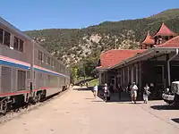
Amtrak's California Zephyr, operating three-days-a-week in both directions between Chicago and Emeryville, California, serves Glenwood Springs, the second busiest station in Colorado, behind only Denver's Union Station.[67] The first commercially successful dome cars were built for the Zephyr family, inspired by Glenwood Canyon.[68]
Due to the scenery, timetables designed for maximum sunlight in Glenwood Canyon, the proximity of downtown, and local tourism, Glenwood Springs receives more passenger traffic than some major cities on the Zephyr line, including Lincoln, Omaha,[69] Grand Junction,[67] and Salt Lake City.[70]
The Zephyr takes a scenic route through the mountains between Denver and Glenwood Springs. Much of the route follows the Colorado River and is away from roads and major development. Part of the route near Glenwood Springs was used for locations in the 1995 action movie Under Siege 2: Dark Territory.
The local transportation authority is Roaring Fork Transportation Authority (RFTA, pronounced "rafta"). RFTA retains ownership of the land previously used for rail traffic to Aspen,[71] a source of occasional consternation in balancing development needs.[72] Proposals to introduce light rail to the valley remain unrealized[73] but were not found economically feasible.[74] VelociRFTA service described below currently serves that role,[75] but RFTA remains committed to realizing the light-rail vision.[76]
Bus
RFTA provides bus transit in Glenwood Springs and throughout the Roaring Fork Valley. VelociRFTA(pronounced "Veloci-rafta", a pun on velociraptor) BRT service, the first rural BRT in the United States, began in September 2013, offering connections between south Glenwood Springs and Aspen roughly every 15 minutes with a 60-minute total travel time. Timetables vary by season, with different frequencies offered during spring, summer, autumn, and winter, to accommodate shifting seasonal demands.[77]
The city also operates an intracity bus service, Ride Glenwood.[78] Ride Glenwood offers a main route from the west side of town along the 6&24 corridor, through downtown, to the south part of Glenwood along Hwy 82.
Greyhound Lines stops in Glenwood Springs on trips between New York and Las Vegas twice per day.[77]
Bus service is provided twice daily by Bustang and runs from Glenwood Springs to both Grand Junction and Denver.[79][77]
Automobile
Glenwood Springs lies along I-70 at exit 116 (main exit), about 150 miles (240 km) west of Denver and 85 miles (137 km) east of Grand Junction. I-70 is one of the main east-west routes through the Rocky Mountains. Colorado State Highway 82 leads southeast from Glenwood Springs up the Roaring Fork Valley 12 miles (19 km) to Carbondale and 41 miles (66 km) to Aspen.
Airport
Glenwood Springs Airport (KGWS), a municipal airport, was built in the early 1940s. The airport was named the 4th most challenging mountain airport by the Aircraft Owners and Pilots Association (AOPA). The main reasons cited were the airport's mountainous location, the runway, and the unpredictable wind gusts, which caused a crash in 2007. In 2004 a Cessna crashed into an apartment near the airport due to engine problems. Visitors to Glenwood Springs more often depart and arrive from Aspen, Eagle, or Denver.
Recreation
Glenwood Springs is known for outdoor recreation, today joined by cultural facilities[80] and the emergence of Glenwood Springs and the Roaring Fork Valley as a whole as a gastronomical destination[81] for foodies.[82] Activities include whitewater rafting, kayaking, caving, cycling, rock climbing, horseback riding, all-terrain vehicle (ATV) tours, off-road Hummer tours, Segway tours, tandem paragliding flights, fishing, and lodge stays in Glenwood Canyon.
Hot Springs
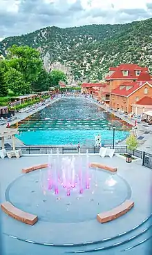
The primary draw of Glenwood Springs for over a hundred years has been the numerous hot springs in the area. There are several hot springs facilities in town that range from 93 °F (34 °C) to 104 °F (40 °C) with varying mineral content.
The hot springs were used by local indigenous people long before the colonization of the Americas, most recently by the Utes.[83][14] The Glenwood Springs area was valued by Native Americans because of the medicinal properties of the water. Before 1800, the area was considered to be of "sacred status" to the Ute people.[12]
Yampah Hot Springs vapor caves are historic underground geothermal steam baths. They are over 100 years old and were used by the Ute people as a source of rejuvenation and healing.[84] There have been tensions between the local Ute people in relation to the use of the caves.[85] Today, the vapor caves consist of three connecting rock chambers. Cave temperatures average 110 to 112 °F (43 to 44 °C).
Iron Mountain Hot Springs features smaller mineral water soaking pools. The underlying geothermal resources and land have been developed and closed several times.[86]
Skiing
Sunlight Ski Area operates a brick and mortar store for lift tickets, rentals, repairs, and equipment in downtown Glenwood. The ski resort itself lies 12 miles (19 km) south of town on County Road 117, also known as Four Mile Road. Sunlight Mountain Resort is well-known to families due to a variety of terrain that leads to a single main base. It offers cross-country skiing in a "Nordic area", sharing the scenery and dense aspen trees that mark other, better-known resorts in the area. There are multiple very steep open grove runs for experts who enjoy tree skiing and powder, including the Heathen with comes in at a 52 degree pitch, the steepest run in Colorado.
Other ski areas such as Aspen, Beaver Creek, and Vail are farther away, but Glenwood Springs is still frequently selected as a home base for visitors to these other resorts due to the hot springs, cultural and dining options, and cheaper lodging in the winter.
Rafting, kayaking, and fishing
Two of the largest rivers in Colorado, the Colorado River and the Roaring Fork River, converge in Glenwood Springs. Both are used for recreation by locals, visitors and commercial outfitters. The waters of the Roaring Fork flowing through Glenwood Springs proper are "Gold Medal" fishing waters,[87] formally so designated by Colorado Parks and Wildlife.
The natural diversity in terrain and gradient of Glenwood Canyon and many local watersheds provides options for most watercraft users' skill levels. The Roaring Fork river provides a float trip with very few class 2 rapids. The Colorado River starting at Grizzly Creek is also a tame class 2 float. Running the Colorado from the Shoshone put-in provides an experience on upper class 3 rapids. Different times of year will accommodate different skill levels, with spring run-off making the rivers vastly more wild, while the rivers are often lackadaisical during the autumn and sometimes frozen over completely in the winter.
There is a dedicated Glenwood Whitewater Park[88] that was developed in the river near Midland Avenue to provide features and terrain for stationary wave surfing, kayaking, and more.
Paragliding and Parasailing
Paragliding and parasailing are summer and shoulder season morning activities, with supportive and generally reliable air currents and views with terrain that stretches more than 2 kilometers above the valley floor visible in multiple directions. There are three different launch points offered on two different mountains in town. Five more sites are available within a less-than-40 minute radius.
Mountain biking
While Carbondale, just upvalley, is already well known as a mountain biking destination, Glenwood Springs has its own plans to make the rugged terrain surrounding town available to riders.[89] There are already many mountain bike trails in the Roaring Fork Valley, most requiring significant fitness and stamina for enjoyment due to the steep slopes and rocky outcroppings.[90]
Some favored routes for locals are the Forest Hollow Trail, winding along the rim above Glenwood Canyon, and the Scout Trail, an extreme drop from the canyon rim into downtown Glenwood. The Jeanne Golay or Red Mountain Trail is a dirt trail up Red Mountain with constant, intense vertical gain that locals use for training and exercise.
Golf
Glenwood Springs is home to a 9-hole golf course referred to by locals as "The Hill" and is within driving distance of mountain golf. Lakota Canyon in nearby New Castle received Golf Magazine's "Best of America's New Courses" list. Several larger courses, most notably including River Valley Ranch and Ironbridge, sprawl through some of the mountain valleys around Glenwood Springs and Carbondale.[91]
There is a mini golf complex with two separate 18 hole courses in West Glenwood.[92]
Bike trails
Two scenic trails host Glenwood Springs as one of the endpoints.[93]
The Glenwood Canyon Recreational Trail[94] winds 16 miles (26 km) through Glenwood Canyon sandwiched between the canyon walls and the Colorado River. It is suitable for families and recreational riders, with several access points and rest areas along the way.
The Rio Grande Trail[95] runs roughly 41 miles (66 km) along the former local Denver and Rio Grande Western Railroad, reaching all the way to Aspen in a rails-to-trails project featured by the Rails-to-Trails Conservancy as the Trail of the Month in April 2016.[96]
Beyond these primary trails, scores of connector trails[34] and designated bike paths[33] exist in the city and throughout the surrounding region. Bike rentals and shuttles are available at several outfitters in town. The network of trails offers several loops within the city, including some that tour the rivers.
Glenwood Caverns
Glenwood Caverns Adventure Park is a moderate-sized amusement park aimed at visitors of all ages.[97] A tram takes visitors up to an extensive system of caverns historically known as the "Fairy Caves", now known as the Glenwood Caverns. Bus transport is available as a backup on windy days. The rides and the tramway are faintly visible throughout the city.
Principal attractions are the caverns and a number of imported thrill rides, including an alpine coaster, the Giant Canyon Swing, which spins riders out over the cliff-edge of Glenwood Canyon to reflect on the Colorado River some 1300 ft below, and the Cliffhanger, a roller coaster which is literally bolted to the mountain.[98] More gentle experiences such as laser tag, lunch, and rides for small children are hosted at the top of the tramway.
The Glenwood Caverns themselves are a complex cave system that winds throughout Iron Mountain, eventually connecting to the same hydrothermal features that power the hot springs.
Glenwood Vaudeville Revue
The Glenwood Vaudeville Revue offers a dinner theater show performing comedy skits, dances, and songs.[99] An old downtown movie theater was purchased and renovated into a dedicated performance venue.[100] The revue has been in professional performance since 2009.[101]
Hanging Lake
Hanging Lake is located in Glenwood Canyon about 7 miles (11 km) east of Glenwood Springs. The lake is reached via a trailhead located near I-70 in the bottom of the canyon. In the summer of 2010 the boardwalk at the lake was replaced. Due to environmental concerns, access to the trail to the lake is permissible only by a shuttle operating in partnership between the U.S. Forest Service and Glenwood Springs from downtown Glenwood Springs from the Community Center from May 1 to Oct. 31.[102]
In the winter of 2018, maintenance and improvement work was performed on the trail.[103] Permits are required to access the lake, as an environmental protection measure introduced alongside the shuttle system.
Hanging Lake and its immediate surroundings were spared during the Grizzly Creek Fire that scorched much of Glenwood Canyon in 2020, along with the trail leading up to it.[104]
Off-roading
The unique geography of Glenwood Springs, etched deep into the surrounding terrain by the confluence of the rivers, provides hundreds of miles of off-road trails minutes from downtown. The most popular trail near Glenwood Springs is called the Transfer Trail. This trail starts on the base of Iron Mountain and travels on the Flat Tops going near many clear mountain lakes and hidden caves. The Transfer Trail was once a primary access route to Glenwood Springs when Glenwood Canyon was considered largely impassible.
Downtown Market
One of several festivals and markets throughout the year, include the Downtown Market farmers' market on Tuesdays throughout the summer months. Vendors offer locally grown and Colorado made products, primarily foodstuffs and crafts and wares. Cooking demonstrations and musical performances are sometimes arranged in a small nearby park.
Notable people
- Kid Curry — Wild West outlaw and gunman
- Doc Holliday — Wild West gunfighter, gambler, and dentist
- Jim Irwin — U.S. Air Force Colonel and NASA astronaut; the eighth man to walk on the moon
- Jack P. Juhan — U.S. Marine Corps Major general, who served in World War II and Korean War.
- Bobby Julich — bike racer and silver medalist at the 2004 Athens Olympics
- Scott McInnis — former U.S. congressman from Colorado
- Blake Neubert — artist
- Sarah Schleper — Alpine skier
- John David Vanderhoof — former Colorado governor
See also
- Outline of Colorado
- State of Colorado
- Colorado cities and towns
- Colorado municipalities
- Colorado counties
- Colorado cities and towns
- Glenwood Canyon
- Glenwood Caverns
- Glenwood Hot Springs
References
- "Active Colorado Municipalities". State of Colorado, Colorado Department of Local Affairs, Division of Local Government. Retrieved January 27, 2021.
- "Colorado Counties". State of Colorado, Colorado Department of Local Affairs, Division of Local Government. Retrieved January 27, 2021.
- "Colorado Municipal Incorporations". State of Colorado, Department of Personnel & Administration, Colorado State Archives. December 1, 2004. Retrieved April 3, 2016.
- "2019 U.S. Gazetteer Files". United States Census Bureau. Retrieved July 1, 2020.
- "US Board on Geographic Names". United States Geological Survey. October 25, 2007. Retrieved January 31, 2008.
- "Population and Housing Unit Estimates". Retrieved May 21, 2020.
- "Springers heading to Junior Olympics national meet". Post Independent/Citizen Telegram. September 10, 2012.
- "Deaf musician concert homecoming of sorts". The Aspen Times/Snowmass Sun. May 8, 2008.
- "ZIP Code Lookup". United States Postal Service. Archived from the original (JavaScript/HTML) on November 4, 2010. Retrieved September 23, 2007.
- "Find a County". National Association of Counties. Archived from the original on May 31, 2011. Retrieved June 7, 2011.
- "Geographic Identifiers: 2010 Demographic Profile Data (G001): Glenwood Springs city, Colorado". American Factfinder. U.S. Census Bureau. Retrieved November 15, 2016.
- "Chapter I: The Natural Backdrop and Spanish Exploration". The Valley of Opportunity: A History of West-Central Colorado BLM Cultural Resource Series (Colorado: No. 12). National Park Service. Retrieved October 5, 2020.
- Conetah, Fred A. (1982). A History of the Northern Ute People. Uintah-Ouray Ute Tribe (previously University of Michigan Press). Retrieved October 5, 2020.
- "Protecting the hot springs and vapor caves in Glenwood Springs". Southern Ute Drum. September 11, 2020. Retrieved October 5, 2020.
- "Ute Indian History in Glenwood Springs, Colorado". Glenwood Springs Colorado. Retrieved October 5, 2020.
- "Archived copy". Archived from the original on March 18, 2016. Retrieved March 16, 2016.CS1 maint: archived copy as title (link)
- "Carbonate — Colorado's strangest county seat". Reporter Herald.
- "Our Living History Part 10". Post Independent.
- "Our Living History Part 11". Post Independent.
- Michaud, Stephen, and Hugh Aynesworth. The Only Living Witness. Authorlink 1999, paperback. ISBN 1-928704-11-5. p. 212-213.
- Conran, Maeve. "The Shoshone Power Plant: "A Big Dog on the River"".
- Best, Allen (September 16, 2002). "Shoshone 'call' runs upstream valleys". Vail Daily. Retrieved November 14, 2016.
- Gardner-Smith, Brent (April 2, 2015). "Colorado Water: Priorities: Protect Shoshone, more water for lower Crystal River". Post Independent. Retrieved November 14, 2016.
- Cabe, Jessica (January 28, 2015). "Garfield, Pitkin combine for No. 1 in Arts Vibrancy Index". Post Independent. Retrieved November 14, 2016.
- "The 16 Best Places to Live in the U.S.: 2015". Outside. August 18, 2015. Retrieved November 14, 2016.
- "Accolades". visitglenwood.com. Archived from the original on September 5, 2015. Retrieved November 14, 2016.
- "Caving/Spelunking". colorado.com. Retrieved November 14, 2016.
- Fowler, Pete (February 23, 2008). "City of Glenwood Springs explores geothermal energy use". Post Independent. Retrieved November 14, 2016.
- "Addendum to the Garfield County Natural Hazards Mitigation Plan" (PDF). City of Glenwood Springs. 2012. Retrieved November 14, 2016.
- "America's Most Walkable Communities". America's Walking. PBS. Retrieved November 14, 2016.
- "America's best walking communities". February 2, 2000.
- "America's Most Walkable Cities". Utne. September–October 2000. Retrieved November 14, 2016.
- "Glenwood Springs Trail System". City of Glenwood Springs. Retrieved November 14, 2016.
- "Trails of Glenwood Springs". visitglenwood.com. Retrieved November 14, 2016.
- Kane, Willa (March 3, 2016). "Frontier Diary: A pedestrian bridge to the heart of Glenwood Springs". Post Independent. Retrieved November 14, 2016.
- "Water Department". City of Glenwood Springs. Retrieved November 14, 2016.
- http://www.ci.glenwood-springs.co.us/DocumentCenter/Home/View/1199
- "Archived copy". Archived from the original on January 23, 2017. Retrieved December 26, 2016.CS1 maint: archived copy as title (link)
- "Gas Wells: COGCC Data". Garfield County, CO. Retrieved November 14, 2016.
- Finley, Bruce (August 15, 2015). "230 Colorado mines are leaking heavy metals into state rivers". The Denver Post. Retrieved November 14, 2016.
- "Air Quality Management". Garfield County. Retrieved November 14, 2016.
- "List of Facilities Reporting to TRI in Envirofacts". Toxics Release Inventory (TRI). United States Environmental Protection Agency. Retrieved November 14, 2016.
- "General Climate Summary Tables - Glenwood Springs, Colorado". Western Regional Climate Center. Retrieved December 17, 2012.
- Miller, Laurel (October 13, 2012). "Roadside America: Colorado's Roaring Fork Valley". Gadling.com. Retrieved November 14, 2016.
- Gulliford, Andrew (1983). "Garfield County, Colorado: The First Hundred Years 1883–1983" (PDF). Garfield County. Retrieved November 14, 2016.
- "Strawberry Days Festival". Glenwood Springs Chamber Resort Association. Archived from the original on November 1, 2016. Retrieved November 14, 2016.
- "Strawberry Days Festival, Glenwood Springs, Colorado". Glenwood Springs Chamber Resort Association. Retrieved November 14, 2016.
- "Census of Population and Housing". Census.gov. Retrieved June 4, 2015.
- "U.S. Census website". United States Census Bureau. Retrieved January 31, 2008.
- Irwin, Neil; Bui, Quoctrung (April 11, 2016). "The Rich Live Longer Everywhere. For the Poor, Geography Matters". The New York Times. Retrieved November 14, 2016.
- "By one measure, this is a good place to be poor". Post Independent.
- Essex, Randy (April 10, 2015). "No room for renters as population, prices rise". Post Independent. Retrieved November 14, 2016.
- Roman, Erin (August 19, 2015). "These Are the 20 Richest Small Towns in America". Bloomberg.
- Essex, Randy. "Why is Glenwood the 7th-richest small town in U.S.?". Post Independent. Retrieved November 14, 2016.
- Stroud, John (April 28, 2016). "Homegrown Meier Skis headed to Denver". Post Independent. Retrieved November 14, 2016.
- "Glenwood Springs Community Broadband Network". City of Glenwood Springs.
- "Project THOR". Northwest Council of Governments.
- "Internet service in western Colorado was so terrible that towns and counties built their own telecom". Colorado Sun.
- Stroud, John (July 21, 2016). "Yampah High among finalists for $10M grant". Post Independent. Retrieved November 14, 2016.
- "News". Post Independent.
- "About Us". Glenwood Springs Post Independent. Retrieved November 14, 2016.
- "Post Independent wins ad, writing, design awards". Post Independent.
- "ASNE Awards 2016". ASNE. Retrieved November 14, 2016.
- "Editor's column: Congrats to the PI staff for recognition from peers". Post Independent.
- "Your Brand of Country, KMTS". KMTS.
- "KSNO". ksno.net.
- "Amtrak Colorado FY15 Fact Sheet" (PDF).
- "Glenwood Canyon Inspired Amtrak's Vista-Dome Railcar". visitglenwood.com. Retrieved November 14, 2016.
- "Amtrak Fact Sheet, Fiscal Year 2015: State of Nebraska" (PDF). Amtrak. Retrieved November 14, 2016.
- "Amtrak Fact Sheet, Fiscal Year 2015: State of Utah" (PDF). Amtrak. Retrieved November 14, 2016.
- "Employer Status Determination: Roaring Fork Railroad Holding Authority (RFRHA) B.A. No. 2784; Board Coverage Decision 12-43". United States Railroad Retirement Board. November 16, 2012. Archived from the original on April 14, 2016. Retrieved November 14, 2016.
- Stroud, John (January 25, 2015). "RFTA access plan angers GarCo commissioners". Post Independent. Retrieved November 14, 2016.
- "RFTA". www.aspentimes.com.
- Beaton, Glenn K. (April 16, 2016). "Beaton: Modest ideas for Aspen". The Aspen Times. Retrieved November 14, 2016.
- "VelociRFTA: Our Nation's First Rural Bus Rapid Transit System" (PDF). VelociRFTA. Archived from the original (PDF) on October 21, 2016. Retrieved November 14, 2016.
- Stewart-Severy, Elizabeth. "RFTA looks for more funding". Aspen Public Radio.
- "Regional Transit Services". City of Glenwood Springs. Retrieved October 5, 2020.
- "Ride Glenwood Springs". City of Glenwood Springs. Retrieved November 14, 2016.
- "Bustang service kicks off Monday". Post Independent. July 13, 2015. Retrieved November 14, 2016.
- "Glenwood Springs Center for the Arts". Glenwood Springs Center for the Arts. Retrieved November 14, 2016.
- Summerlin, Ryan (January 21, 2016). "As mountain towns diversify, what's next?". Post Independent. Retrieved November 14, 2016.
- Stroud, John (March 14, 2016). "Record year for Glenwood Springs retail sales". Post Independent. Retrieved November 14, 2016.
- Rockwell, Wilson (1956). The Utes: A Forgotten People. Denver: Sage Books. p. 21.
- Krivonen, Marci (September 26, 2013). "Glenwood Springs "Sweats" Attempt to Revive Ute Indian Culture". Aspen Public Radio. Retrieved October 5, 2020.
- Phippen, Thomas (October 30, 2018). "Ute leader alleges wrongdoing in Glenwood Springs' Yampah cave ban". Aspen Times. Retrieved October 5, 2020.
- "Adventure Park, both hot springs to reopen Monday in Glenwood Springs". Aspen Times. June 6, 2020. Retrieved October 5, 2020.
- "Fishing". visitglenwood.com. Retrieved November 14, 2016.
- "Whitewater Activity Area". Glenwood Springs Parks and Recreation. Archived from the original on October 21, 2016. Retrieved November 14, 2016.
- Stroud, John (March 1, 2015). "Glenwood area mountain biking potential abounds in new plan". The Aspen Times. Retrieved November 14, 2016.
- "Welcome to RFMBA!". Roaring Fork Mountain Bike Association. Retrieved November 14, 2016.
- "Golf Courses". Glenwood Springs Colorado. Retrieved October 5, 2020.
- "Glenwood Springs, Colorado Mini Golf Courses". www.golflink.com.
- "Rio Grande Trail up for national award". Post Independent. March 30, 2016. Retrieved November 14, 2016.
- "Glenwood Canyon Bike Path". visitglenwood.com. Retrieved November 14, 2016.
- "Trail Information: Rio Grande Trail". Roaring Fork Transportation Authority. Retrieved November 14, 2016.
- Stark, Laura (April 11, 2016). "Colorado's Rio Grande Trail". Rails-to-Trails Conservancy. Retrieved November 14, 2016.
- Graff, Ryan (January 6, 2005). "Adventure park goes beyond caverns". Post Independent. Retrieved October 5, 2020.
- "Glenwood Caverns Park Opens 'Cliffhanger', Highest Elevation Roller Coaster in U.S." The Huffington Post. June 15, 2012. Retrieved November 14, 2016.
- Shrull, Dale (August 8, 2009). "Glenwood Vaudeville is good live entertainment". Post Independent. Retrieved October 5, 2020.
- Stroud, John (November 26, 2013). "Whole lotta new for the Glenwood Vaudeville Revue". Post Independent. Retrieved November 14, 2016.
- Cabe, Jessica (December 1, 2014). "The Glenwood Springs Vaudeville Revue's wacky holiday show opens today". Post Independent. Retrieved November 14, 2016.
- "Forest Service, Glenwood Springs seal partnership for new Hanging Lake shuttle". Post Independent.
- "Forest Service, Glenwood Springs seal partnership for new Hanging Lake shuttle". Post Independent.
- "'Hanging Lake miracle' — Further assessments reveal no damage to trail infrastructure, lake; rockfall, slide danger in area now the chief concern". Post Independent.
External links
| Wikivoyage has a travel guide for Glenwood Springs. |
Glenwood Tourism:
- Glenwood Springs Chamber Resort Association
- Visitglenwood.com, Glenwood Springs official travel website
| Major cities | 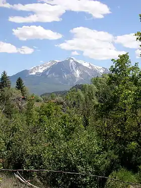 | |
|---|---|---|
| Other communities | ||
| Near valley | ||
| Ski resorts | ||
| Bodies of water | ||
Municipalities and communities of Garfield County, Colorado, United States | ||
|---|---|---|
| Cities | 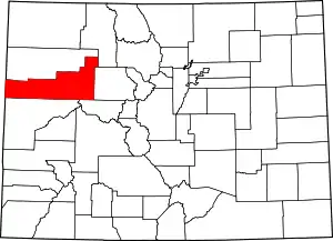 Map of Colorado highlighting Garfield County | |
| Towns | ||
| CDPs | ||
| Unincorporated communities | ||
| ||

| Authority control |
|---|