Basalt, Colorado
The Town of Basalt is a Home Rule Municipality located in Eagle and Pitkin counties, Colorado, United States.[9] The town population was 3,857 at the 2010 United States Census.
Basalt, Colorado | |
|---|---|
Home Rule Municipality[1] | |
| Town of Basalt[1] | |
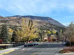 Basalt with Basalt Mountain in the background. | |
| Nickname(s): "The Heart of the Roaring Fork Valley" | |
 | |
 Basalt Location of the Town of Basalt in the United States. | |
| Coordinates: 39°21′29″N 107°01′07″W[2] | |
| Country | |
| State | |
| County[3] | Eagle County Pitkin County |
| Town[1] | Basalt |
| Incorporated | August 26, 1901[4] |
| Government | |
| • Type | Home Rule Municipality[1] |
| • Mayor | Bill Kane |
| Area | |
| • Total | 2.00 sq mi (5.18 km2) |
| • Land | 1.99 sq mi (5.16 km2) |
| • Water | 0.01 sq mi (0.02 km2) |
| Elevation | 6,611 ft (2,015 m) |
| Population (2010) | |
| • Total | 3,857 |
| • Estimate (2019)[7] | 4,157 |
| • Density | 2,087.90/sq mi (805.95/km2) |
| Time zone | UTC-7 (MST) |
| • Summer (DST) | UTC-6 (MDT) |
| ZIP code | 81621[8] |
| Area code(s) | 970 |
| FIPS code | 08-04935 |
| GNIS feature ID | 0175038 |
| Highways | |
| Website | Official website |
History
Basalt was first named Aspen Junction, after the Junction it served which led to present day Aspen, Colorado. Aspen Junction was a territory serving Aspen to Leadville Mining towns, with the Railroad Junction, also going West and South to Carbondale and Glenwood Springs. It was first served by the Colorado Midland Railroad, it was later bought out in 1901 by the Denver & Rio Grande Railroad.[10][11]
The town was named for the basaltic rock formation on Basalt Mountain, and began as a railroad town.[12] The town was incorporated in 1901.[13]
Geography
Basalt is located at 39°22′6″N 107°2′18″W (39.368382, -107.038263),[14] along State Highway 82, and at the confluence of the Fryingpan and Roaring Fork rivers. According to the United States Census Bureau, the town has a total area of 1.9 square miles (4.9 km2), of which 1.9 square miles (4.9 km2) is land and 0.04 square miles (0.10 km2) (1.03%) is water.
Demographics
| Historical population | |||
|---|---|---|---|
| Census | Pop. | %± | |
| 1900 | 382 | — | |
| 1910 | 235 | −38.5% | |
| 1920 | 185 | −21.3% | |
| 1930 | 148 | −20.0% | |
| 1940 | 212 | 43.2% | |
| 1950 | 173 | −18.4% | |
| 1960 | 213 | 23.1% | |
| 1970 | 419 | 96.7% | |
| 1980 | 529 | 26.3% | |
| 1990 | 1,128 | 113.2% | |
| 2000 | 2,681 | 137.7% | |
| 2010 | 3,857 | 43.9% | |
| 2019 (est.) | 4,157 | [7] | 7.8% |
| U.S. Decennial Census[15] | |||
As of the census[16] of 2000, there were 2,681 people, 1,052 households, and 637 families residing in the town. The population density was 1,394.8 people per square mile (539.1/km2). There were 1,218 housing units at an average density of 633.7 per square mile (244.9/km2). The racial makeup of the town was 91.53% White, 0.48% African American, 0.52% Native American, 1.27% Asian, 0.11% Pacific Islander, 4.77% from other races, and 1.31% from two or more races. Hispanic or Latino of any race were 11.75% of the population.
There were 1,052 households, out of which 34.0% had children under the age of 18 living with them, 50.1% were married couples living together, 7.4% had a female householder with no husband present, and 39.4% were non-families. 24.0% of all households were made up of individuals, and 2.0% had someone living alone who was 65 years of age or older. The average household size was 2.55 and the average family size was 3.00.
In the town, the population was spread out, with 23.6% under the age of 18, 6.8% from 18 to 24, 42.3% from 25 to 44, 24.4% from 45 to 64, and 3.0% who were 65 years of age or older. The median age was 34 years. For every 100 females, there were 108.8 males. For every 100 females age 18 and over, there were 110.6 males.
The median income for a household in the town was $67,200, and the median income for a family was $73,375. Males had a median income of $40,791 versus $30,532 for females. The per capita income for the town was $30,746. About 4.9% of families and 6.3% of the population were below the poverty line, including 5.9% of those under age 18 and 6.8% of those age 65 or over.
Tourism
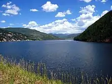
Basalt is well known for its Gold Medal trout fishing in the Frying Pan River. Ruedi Reservoir is also a popular regional destination for boating and other watersports. Basalt is a hub for mountain biking in the Roaring Fork valley. There are a dozen world class cross country trails as well as lift-accessed downhilling within 15 miles of Basalt, both up and down the valley.
Transportation
- Roaring Fork Transportation Authority (RFTA) provides bus transit in Basalt.
- Basalt's public transit system (WE-CYCLE) supplied by PBSC.
Notable people
- Wally Dallenbach Jr., NASCAR driver
- Joey Diaz, comedian
- Christy Smith, contestant on Survivor: Amazon
- Torin Yater-Wallace, Olympian, freeskier and the youngest person ever to medal at the Winter X Games.
- Ann Korologos, former United States Secretary of Labor
- Tom Korologos, former United States Ambassador to Belgium
See also
- Outline of Colorado
- State of Colorado
- Colorado cities and towns
- Colorado municipalities
- Colorado counties
- Colorado cities and towns
References
- "Active Colorado Municipalities". State of Colorado, Colorado Department of Local Affairs, Division of Local Government. Retrieved January 31, 2021.
- "2014 U.S. Gazetteer Files: Places". United States Census Bureau. July 1, 2014. Retrieved January 5, 2015.
- "Colorado Counties". State of Colorado, Colorado Department of Local Affairs, Division of Local Government. Retrieved January 31, 2021.
- "Colorado Municipal Incorporations". State of Colorado, Department of Personnel & Administration, Colorado State Archives. 2004-12-01. Archived from the original on 27 September 2007. Retrieved 2007-08-18.
- "2019 U.S. Gazetteer Files". United States Census Bureau. Retrieved July 1, 2020.
- "US Board on Geographic Names". United States Geological Survey. 2007-10-25. Retrieved 2008-01-31.
- "Population and Housing Unit Estimates". United States Census Bureau. May 24, 2020. Retrieved May 27, 2020.
- "ZIP Code Lookup". United States Postal Service. August 19, 2007. Archived from the original (JavaScript/HTML) on 18 August 2007. Retrieved August 19, 2007.
- "Active Colorado Municipalities | Colorado Department of Local Affairs". dola.colorado.gov. Retrieved 2020-09-21.
- "History of Basalt | Basalt, CO - Official Website". www.basalt.net. Retrieved 2020-02-19.
- "History of Basalt, Colorado". Basalt Mountain Inn. Retrieved 2020-02-19.
- "Welcome to Basalt, Colorado". Town of Basalt. Archived from the original on 2012-03-09. Retrieved 2012-03-07.
- "Basalt, Colorado". City-Data.com. Retrieved 2012-03-07.
- "US Gazetteer files: 2010, 2000, and 1990". United States Census Bureau. 2011-02-12. Retrieved 2011-04-23.
- "Census of Population and Housing". Census.gov. Retrieved June 4, 2015.
- "U.S. Census website". United States Census Bureau. Retrieved 2008-01-31.
External links
| Wikimedia Commons has media related to Basalt, Colorado. |
| Major cities |  | |
|---|---|---|
| Other communities | ||
| Near valley | ||
| Ski resorts | ||
| Bodies of water | ||
Municipalities and communities of Eagle County, Colorado, United States | ||
|---|---|---|
| Towns | 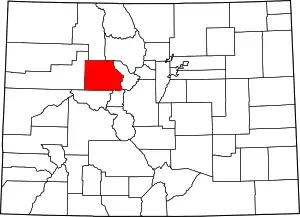 Map of Colorado highlighting Eagle County | |
| CDPs | ||
| Unincorporated communities |
| |
| Ghost towns | ||
| Footnotes | ‡This populated place also has portions in an adjacent county or counties | |
| ||
Municipalities and communities of Pitkin County, Colorado, United States | ||
|---|---|---|
| City | 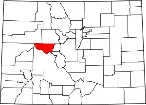 Map of Colorado highlighting Pitkin County | |
| Towns | ||
| CDPs | ||
| Unincorporated communities | ||
| Ghost towns | ||
| Footnotes | ‡This populated place also has portions in an adjacent county or counties | |
| ||

| Authority control |
|---|