Carbondale, Colorado
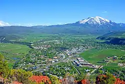
The Town of Carbondale is a Home Rule Municipality located in Garfield County, Colorado, United States. Carbondale is a part of the Glenwood Springs, CO Micropolitan Statistical Area. The town population was 6,427 at the 2010 United States Census. The town is located in the Roaring Fork Valley, downstream from Aspen and upstream from the mouth of the Roaring Fork River at Glenwood Springs. The town proper sits on the south bank of the river, at the confluence of the Crystal River. Carbondale's horizon is dominated by the 12,953 ft (3,952 m) tall Mount Sopris several miles to the south of town.
Carbondale, Colorado | |
|---|---|
Home Rule Municipality[1] | |
| Town of Carbondale[1] | |
 Mount Sopris, south of town, as viewed from Red Hill/Mushroom Rock. | |
| Nickname(s): The Ultimate Rocky Mountain Hideout | |
 Location of the Town of Carbondale in Garfield County, Colorado. | |
 Carbondale Location of the Town of Carbondale in the United States. | |
| Coordinates: 39°23′41″N 107°12′52″W[2] | |
| Country | |
| State | |
| County | Garfield County[3] |
| Town | Carbondale[1] |
| Incorporated (town) | April 26, 1888[4] |
| Government | |
| • Type | Home Rule Municipality[1] |
| Area | |
| • Total | 2.02 sq mi (5.24 km2) |
| • Land | 2.02 sq mi (5.24 km2) |
| • Water | 0.00 sq mi (0.00 km2) |
| Elevation | 6,181 ft (1,881 m) |
| Population (2010) | |
| • Total | 6,427 |
| • Estimate (2019)[6] | 6,898 |
| • Density | 3,411.47/sq mi (1,317.21/km2) |
| Time zone | UTC-7 (MST) |
| • Summer (DST) | UTC-6 (MDT) |
| ZIP code | 81623[7] |
| Area code(s) | 970 Exchange: 963 |
| FIPS code | 08-12045 |
| GNIS feature ID | 0174841 |
| Website | carbondalegov |
Geography
According to the United States Census Bureau, Carbondale has a total area of 2.0 square miles (5.2 km2), all of it land.
Demographics
As of the census[8] of 2000, there were 5,196 people, 1,744 households, and 1,168 families residing in the town. The population density was 2,583.8 people per square mile (998.1/km2). There were 1,821 housing units at an average density of 905.5 per square mile (349.8/km2). The racial makeup of the town was 84.28% White, 0.65% African American, 0.54% Native American, 0.69% Asian, 0.02% Pacific Islander, 11.80% from other races, and 2.02% from two or more races. Hispanic or Latino of any race were 32.12% of the population.
There were 1,744 households, out of which 41.1% had children under the age of 18 living with them, 51.8% were married couples living together, 10.5% had a female householder with no husband present, and 33.0% were non-families. 20.3% of all households were made up of individuals, and 3.4% had someone living alone who was 65 years of age or older. The average household size was 2.89 and the average family size was 3.32.
In the town, the population was spread out, with 26.1% under the age of 18, 11.7% from 18 to 24, 37.4% from 25 to 44, 18.7% from 45 to 64, and 6.0% who were 65 years of age or older. The median age was 31 years. For every 100 females, there were 110.1 males. For every 100 females age 18 and over, there were 107.7 males.
The median income for a household in the town was $52,429, and the median income for a family was $55,726. Males had a median income of $33,025 versus $24,786 for females. The per capita income for the town was $20,383. About 9.8% of families and 12.2% of the population were below the poverty line, including 13.0% of those under age 18 and 5.0% of those age 65 or over.
History
| Historical population | |||
|---|---|---|---|
| Census | Pop. | %± | |
| 1890 | 166 | — | |
| 1900 | 173 | 4.2% | |
| 1910 | 284 | 64.2% | |
| 1920 | 310 | 9.2% | |
| 1930 | 283 | −8.7% | |
| 1940 | 437 | 54.4% | |
| 1950 | 441 | 0.9% | |
| 1960 | 612 | 38.8% | |
| 1970 | 726 | 18.6% | |
| 1980 | 2,084 | 187.1% | |
| 1990 | 3,004 | 44.1% | |
| 2000 | 5,196 | 73.0% | |
| 2010 | 6,427 | 23.7% | |
| 2019 (est.) | 6,898 | [6] | 7.3% |
| U.S. Decennial Census[9] | |||
Carbondale takes its name from Carbondale, Pennsylvania, hometown of some of Carbondale's early settlers.[10] Carbondale's economy was initially agriculturally based. Farmers and ranchers capitalized on open lands around Carbondale to supply food for miners in nearby Aspen, then a booming center of silver mining activity. Early in the 20th century, before the rise of industrial agriculture in Idaho, Carbondale's primary agricultural product was potatoes. The legacy lives on in Potato Day, an annual fall parade and cookout in Sopris Park. Despite the non-geologic origins of the town's name, the Carbondale area does in fact possess significant coal resources. Until the late 1980s Carbondale's economy was primarily based on coal operations up the Crystal River Valley. The coal mined from the area was favored for its high burning temperature, low sulphur content, and density. However, the coal deposits also contained significant amounts of methane gas. In 1981, a methane gas explosion killed 15 miners and by 1991 the mines closed down permanently. The rise of Aspen as a skiing mecca and subsequent hyperinflation of its real estate prices has forced a majority of its workers downvalley to other towns like Carbondale. Thus, especially since the 1980s, Carbondale has partly served as a bedroom community to Aspen. More recently Carbondale has seen a boom of second-home construction, arts and recreational amenities, and tourism as the area's wealth and renown has grown. A notable arts event is the annual summer arts and music festival, Mountain Fair held in Sopris Park. The event has annual attendance between 18,000 and 20,000 people over the three days of which it is held, being nearly triple the population of Carbondale.[11] KDNK is an FM radio station licensed to Carbondale.[12]
Schools
Carbondale is within the Roaring Fork School District.
Elementary and middle schools
- Crystal River Elementary School
- Carbondale Middle School
- Carbondale Community School
- Ross Montessori School
- Waldorf School on the Roaring Fork
High schools
- Roaring Fork High School (RFHS)
- Bridges High School (BHS)
- Colorado Rocky Mountain School (CRMS)
Transportation
Roaring Fork Transportation Authority provides bus transit service in Carbondale.
See also
- Outline of Colorado
- State of Colorado
- Colorado cities and towns
- Colorado municipalities
- Colorado counties
- Colorado cities and towns
References
- "Active Colorado Municipalities". State of Colorado, Colorado Department of Local Affairs, Division of Local Government. Retrieved February 1, 2021.
- "2014 U.S. Gazetteer Files: Places". United States Census Bureau. July 1, 2014. Retrieved January 5, 2015.
- "Colorado Counties". State of Colorado, Colorado Department of Local Affairs, Division of Local Government. Retrieved February 1, 2021.
- "Colorado Municipal Incorporations". State of Colorado, Department of Personnel & Administration, Colorado State Archives. 2004-12-01. Retrieved 2007-09-02.
- "2019 U.S. Gazetteer Files". United States Census Bureau. Retrieved July 1, 2020.
- "Population and Housing Unit Estimates". United States Census Bureau. May 24, 2020. Retrieved May 27, 2020.
- "ZIP Code Lookup". United States Postal Service. Archived from the original (JavaScript/HTML) on September 3, 2007. Retrieved September 4, 2007.
- "U.S. Census website". United States Census Bureau. Retrieved 2008-01-31.
- "Census of Population and Housing". Census.gov. Retrieved June 4, 2015.
- Dawson, John Frank (1954). Place names in Colorado: why 700 communities were so named, 150 of Spanish or Indian origin. Denver, CO: The J. Frank Dawson Publishing Co. p. 13.
- "Mountain Fair - Carbondale Arts". Carbondale Arts. Retrieved 2018-07-25.
- "KDNK". www.kdnk.org. Retrieved 2019-03-06.
External links
| Wikimedia Commons has media related to Carbondale, Colorado. |
| Major cities | 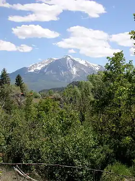 | |
|---|---|---|
| Other communities | ||
| Near valley | ||
| Ski resorts | ||
| Bodies of water | ||
Municipalities and communities of Garfield County, Colorado, United States | ||
|---|---|---|
| Cities | 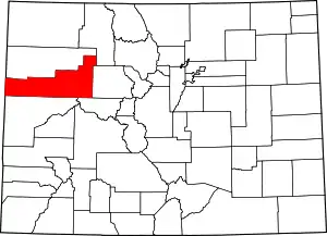 Map of Colorado highlighting Garfield County | |
| Towns | ||
| CDPs | ||
| Unincorporated communities | ||
| ||

| Authority control |
|---|