Balonne Highway
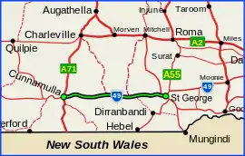
The Balonne Highway, a state highway of Queensland, is the continuation westward of State Route 49 (Moonie Highway) from the town of St George to its termination at Cunnamulla.[1] There are no large settlements between St George and Cunnamulla.[2]
Balonne Highway | |
|---|---|
 | |
Balonne Highway (green on black) | |
| General information | |
| Type | Highway |
| Length | 288 km (179 mi) |
| Route number(s) | |
| Major junctions | |
| East end | |
| West end | |
| Location(s) | |
| Major settlements | Bollon, Nebine, Linden |
| Highway system | |
Major intersections
| LGA | Location | km | mi | Destinations | Notes |
|---|---|---|---|---|---|
| Balonne | St George | 0 | 0.0 | south - Nindigully | Eastern end of Balonne Highway (State Route 49) |
| Balonne River | 1.6 | 0.99 | Andrew Nixon Bridge | ||
| Balonne | St George | 5.2 | 3.2 | Mitchell-St George Road - north - Mitchell | |
| Bollon | 102 | 63 | Bollon-Dirranbandi Road - south - Dirranbandi | ||
| 113 | 70 | Mitchell-Bollon Road - north - Mitchell | |||
| Paroo | Nebine | 160 | 99 | Charleville-Bollon Road - north - Charleville | |
| Cunnamulla | 288 | 179 | south - Bourke | Western end of Balonne Highway | |
| 1.000 mi = 1.609 km; 1.000 km = 0.621 mi | |||||
References
- Queensland Government - Department of Transport and Main Roads - Maps
- Hema, Maps (2007). Australia Road and 4WD Atlas (Map). Eight Mile Plains Queensland: Hema Maps. pp. 8/19. ISBN 978-1-86500-456-3.
This article is issued from Wikipedia. The text is licensed under Creative Commons - Attribution - Sharealike. Additional terms may apply for the media files.