Damansara–Puchong Expressway
The Damansara–Puchong Expressway ![]() is a 40.0-kilometre (24.9-mile) major controlled-access highway in the Petaling District of Selangor, Malaysia. The expressway runs in a north–south direction between Bandar Sri Damansara and Putra Permai, near Putrajaya, forming a major thoroughfare in the cities of Petaling Jaya and Puchong. A short east–west spur of the expressway connects Pusat Bandar Puchong to the suburb of UEP Subang Jaya.
is a 40.0-kilometre (24.9-mile) major controlled-access highway in the Petaling District of Selangor, Malaysia. The expressway runs in a north–south direction between Bandar Sri Damansara and Putra Permai, near Putrajaya, forming a major thoroughfare in the cities of Petaling Jaya and Puchong. A short east–west spur of the expressway connects Pusat Bandar Puchong to the suburb of UEP Subang Jaya.
| |
|---|---|
| Damansara–Puchong Expressway Lebuhraya Damansara–Puchong | |
| Route information | |
| Maintained by Lingkaran Trans Kota Holdings Bhd | |
| Length | 40.0 km (24.9 mi) Main route: 32.5 km (20.2 mi) Puchong West link: 7.5 km (4.7 mi) |
| Existed | 1997–present |
| History | Completed in December 1998 and opened to public in January 1999 |
| Major junctions | |
| North end | |
| South end | |
| Location | |
| Primary destinations | Bukit Lanjan, Damansara Perdana, Mutiara Damansara, Bandar Utama, Taman Tun Dr Ismail, Kelana Jaya, Bandar Sunway, Subang Jaya, Petaling Jaya, Puchong, UEP Subang Jaya, Sungai Besi, Shah Alam, Putrajaya, Cyberjaya |
| Highway system | |
Route description
The Damansara–Puchong Expressway begins at the interchange with the Sungai Buloh Highway and Kuala Lumpur Middle Ring Road 2.
The Kelana Jaya line, Sungai Buloh–Kajang line and Sri Petaling line runs alongside substantial portions of the expressway.
History
The construction of the Damansara–Puchong Expressway was awarded to Lingkaran Trans Kota Holdings Bhd (Litrak). On 23 April 1996, the concession agreement was signed between the Government of Malaysia and Litrak for the privatisation of the improvement, upgrading, design, construction, maintenance, operations and management of Damansara–Puchong Expressway.
Construction of the expressway began on September 1996 and completed on December 1998. The work was awarded on a turnkey basis (i.e. design and construct) to Gamuda–Irama Duta Joint Venture (GIDJV) at a cost of RM 1.1 billion. The overall cost for expressway is RM 1.4 billon. The expressway was opened to traffic on 25 January 1999.
With the completion of the Damansara–Puchong Expressway, the Kuala Lumpur Middle Ring Road 2 was substantially completed on the west of Kuala Lumpur which provides for free flow and ease congestion. It also links Bandar Sunway to Puchong and traveling time is shortened between Petaling Jaya and Puchong. The expressways connects the Putrajaya and Hicom/Shah Alam with the Middle Ring Road.
The expressway used to have its own electronic toll collection system known as the "FasTrak". From 1 July 2004, the FasTrak was replaced by the Touch 'n Go and SmartTAG systems.
Original routes
The construction of the Damansara–Puchong Expressway includes the acquisition and upgrades of several major roads as follows:-
| Highway shield | Roads | Sections |
|---|---|---|
| Jalan Sungai Penchala | Bukit Lanjan–Kampung Sungai Penchala | |
| Jalan Damansara | Sri Damansara–Taman Tun Dr Ismail | |
| Jalan Perbandaran | Taman Tun Dr Ismail–Federal Highway | |
| Jalan Sungei Way | Federal Highway–Bandar Sunway | |
| Jalan PJS Utama | Bandar Sunway–PJS | |
| Jalan Puchong–Petaling Jaya | Puchong Jaya–Puchong Intan | |
| Jalan Puchong–Shah Alam | Puchong Intan–Subang Jaya South | |
| Jalan Puchong Perdana | Jalan Puchong–Shah Alam–Jalan Puchong–Seri Kembangan | |
| Jalan Puchong–Seri Kembangan | Puchong Perdana–Serdang |
Developments
Puchong Jaya interchange
The upgrading works of the Puchong Jaya interchange including ramp from Bukit Jalil Highway to the expressway began in 2002 and was completed in 2005.
Kelana Jaya and Kampung Baru Puchong interchanges
The Kelana Jaya interchange which used to be a U-turn junction was completed in 2007.
The Kampung Baru Puchong interchange was upgraded from underpass to diamond interchange was completed in 2007.
TTDI interchange
The TTDI interchange upgrading project is being undertaken by Lingkaran Trans Kota Holdings Bhd (Litrak) to improve the level of service on LDP.
The project which commenced in August 2007 with a total budget of RM133 million involves widening of certain stretches and building a flyover and an underpass at TTDI Interchange.
The congestion at the interchange is mainly due to multiple weaving of traffic from TTDI to Bandar Utama, TTDI to Damansara Utama and Damansara Utama to TTDI. Once completed, the upgraded interchange will ease traffic flow from TTDI to Bandar Utama/Kepong and there will also be smoother flow on the LDP mainline to Bandar Utama and Kepong.
The upgraded interchange will also allow more green time for localized traffic movement.
The project work involved the following:
- Upgrading of existing TTDI Interchange into a fully grade-separated Interchange through the construction of a new 2-lane bridge flyover for northbound traffic towards Kepong
- Localised widening of northbound and southbound slip roads
- An underpass from TTDI to Bandar Utama and Kepong.
The project was scheduled for full completion in May 2011 with the flyover expected to be opened earlier upon its completion.
Notable incidents
- 1 August 2013 – Chua Boon Huat, Malaysian's national hockey player died in a car accident on Damansara–Puchong Expressway near Kelana Jaya LRT station at Kelana Jaya.
Junction list
The entire expressway is located within the Petaling District in Selangor. Only major junctions are listed in these tables.
| Location | km | Exit | Name | Destinations | Notes |
|---|---|---|---|---|---|
| Bandar Sri Damansara | 0.0 | – | – | Persiaran Jati – Bandar Sri Damansara | |
| | Penchala layby (northbound) | ||||
| 0.8 | – | – | Persiaran Ara – Bandar Sri Damansara Jalan 1/62B – Bandar Menjalara | Northbound exit and entrance to/from Persiaran Ara, southbound exit and entrance to/from Jalan 1/62B only | |
| Bukit Lanjan | | Penchala toll plaza (barrier system) | |||
| 4.0 | – | – | Jalan Bukit Lanjan – Bukit Lanjan | Southbound exit and entrance only | |
| | 1101 | – | Jalan PJU 8/1 – Damansara Perdana Jalan PJU 7/9 – Mutiara Damansara | No southbound exit to Jalan PJU 7/9, no entrance from Jalan PJU 7/9 | |
| Bandar Utama | 5.0 | – | – | Persiaran Surian – (Mutiara Damansara) | Northbound exit and entrance only |
| | 1103 | Bandar Utama | Jalan Burhanuddin Helmi – Taman Tun Dr. Ismail, Bandar Utama | Northbound traffic must exit at exit 1104 to access this exit | |
| | – | – | Persiaran Bandar Utama – Bandar Utama | Northbound exit (via exit 1104) and entrance only | |
| | – | – | Jalan Leong Yew Koh – (Taman Tun Dr. Ismail) | Southbound exit and entrance only | |
| Damansara Utama | | 1104 | Taman Tun Dr. Ismail | Jalan Damansara – Sections 16 & 18, Bandar Utama, Kuala Lumpur | |
| | – | – | Jalan SS 21/56 – Damansara Utama, Kota Damansara | Northbound exit and entrance only | |
| | 1106 | Damansara Utama | |||
| Damansara Jaya | | – | – | Jalan SS 22/41 – Damansara Jaya | Northbound exit and entrance only |
| | – | – | Jalan SS 2/75 – (Section SS2) | Southbound exit and entrance only | |
| 9.5 | 1107 | SS2 | Jalan SS 2/55 – Section SS2, Damansara Jaya | ||
| – | | – | – | Jalan SS 23/13 – (Section SS23) | Northbound exit and entrance only |
| Kelana Jaya | | 1108 | Taman Megah | Jalan SS 24/9 – Section SS24 Jalan SS 2/3 – Sections SS2 & SS4 | |
| | – | – | Jalan SS 25/23 – Taman Mayang Emas | Northbound exit and entrance only | |
| | – | – | Jalan SS 7/26 – Section SS7 Jalan Bahagia – Section SS6 Jalan SS 25/29 – Section SS25, Taman Emas | ||
| 15.0 | 1110 | Jalan Majlis | Jalan Majlis – Section SS3 Majlis Link – Sungei Way Free Industrial Zone | ||
| Setia Jaya | 16.4 | 1111 | – | ||
| Bandar Sunway | 17.5 | 1112 | PJS | Southbound traffic must exit at exit 1111 to access this exit | |
| | – | – | Jalan Lagoon Selatan – (Bandar Sunway) | Northbound exit and entrance only | |
| | – | – | Jalan PJS 9/1 – PJS 9 & 11 | Southbound exit and entrance only | |
| | Petaling Jaya layby (southbound) | ||||
| | Petaling Jaya toll plaza (barrier system) | ||||
| | Petaling Jaya layby (northbound) | ||||
| – | 19.7 | Klang River bridge | |||
| Puchong Jaya | 19.9 | 1113 | Sunway | Southbound traffic must enter local lanes at Petaling Jaya South toll plaza to access this exit | |
| | 1114 | Puchong Jaya | Southbound traffic must enter local lanes at Petaling Jaya South toll plaza to access this exit | ||
| | – | – | Persiaran Puchong Jaya Selatan – (Bandar Puchong Jaya) | Southbound exit (from local lanes) and entrance only | |
| Pusat Bandar Puchong | | – | – | Persiaran Wawasan – Taman Wawasan | Southbound exit and entrance only |
| | – | – | Lebuh Puteri – Pusat Bandar Puchong Bandar Puteri | ||
| | – | – | Southbound exit and entrance only | ||
| | 1118 | Puchong Intan | |||
| Puchong Perdana | | 1119 | Puchong Perdana | Lebuh Puteri – Puchong Perdana, Kampung Baharu Puchong | |
| Puchong Utama | | – | – | Persiaran Taman Tasik Prima – Taman Puchong Utama, Taman Maju Jaya, Taman Industri Puchong Perdana | |
| 30.0 | – | – | |||
| Bukit Puchong | | – | – | Persiaran Bukit Puchong – Bandar Bukit Puchong, Kampung Baru Batu 14, Saujana Puchong | Southbound exit and entrance only |
| | 1121 | Bukit Puchong | Jalan Bukit Puchong – Bandar Bukit Puchong | ||
| | Puchong South layby (southbound) | ||||
| | Puchong South toll plaza (barrier system) | ||||
| Putra Permai | | Ayer Hitam layby (northbound) | |||
| 32.5 | 1123 | Serdang | |||
| Through to | |||||
1.000 km = 0.621 mi; 1.000 mi = 1.609 km
| |||||
Puchong West link
| Location | km | Exit | Name | Destinations | Notes |
|---|---|---|---|---|---|
| Pusat Bandar Puchong | | 1118 | Puchong Intan | ||
| | – | – | Jalan Sri Puchong 1 – (Bandar Sri Puchong) | Eastbound exit and entrance only | |
| | Puchong West toll plaza (barrier system) | ||||
| – | | Klang River bridge | |||
| UEP Subang Jaya | | – | – | Persiaran Harmoni – Putra Heights | |
| 0.2– 0.4 | 1125 | – | Persiaran Kewajipan – UEP Subang Jaya (USJ 21), Subang Jaya | ||
| Through to | |||||
1.000 km = 0.621 mi; 1.000 mi = 1.609 km
| |||||
Gallery
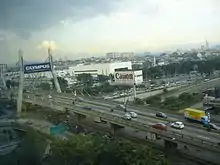 The cable-stayed bridge of Damansara–Puchong Expressway spanning over its intersection with Federal Highway in Petaling Jaya. Kuala Lumpur can be seen in the distant background on the right corner of the picture.
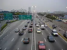 The Sunway stretch of Damansara–Puchong Expressway during the evening rush hour.
 Petaling Jaya toll plaza of trip from Puchong to Petaling Jaya. The modern design is LDP standard design of toll plazas with electronic toll collection of cash lanes and Touch 'n Go lanes seen here. The SmartTAG lanes immediately next to Touch n Go lanes.
 LDP Terminus USJ
 LDP highway Puchong portion, which is famous for traffic congestion