Penang Bridge
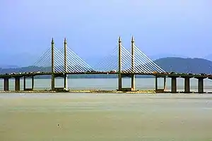
The Penang Bridge ![]() is a 13.5-kilometre (8.4-mile)[2][3] dual carriageway toll bridge and controlled-access highway in the state of Penang, Malaysia. The bridge connects Perai on the mainland side of the state with Gelugor on the island, crossing the Penang Strait. The bridge was the first and, until 2014, the only road connection between the peninsula and the island. The bridge is the second-longest bridge in Malaysia and the fifth-longest in Southeast Asia by total length, with a length over water of 8.4 kilometres (5.2 miles).[3]
is a 13.5-kilometre (8.4-mile)[2][3] dual carriageway toll bridge and controlled-access highway in the state of Penang, Malaysia. The bridge connects Perai on the mainland side of the state with Gelugor on the island, crossing the Penang Strait. The bridge was the first and, until 2014, the only road connection between the peninsula and the island. The bridge is the second-longest bridge in Malaysia and the fifth-longest in Southeast Asia by total length, with a length over water of 8.4 kilometres (5.2 miles).[3]
| |
|---|---|
| Penang Bridge Jambatan Pulau Pinang | |
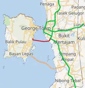
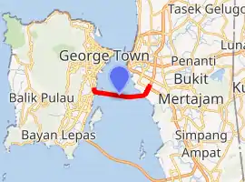
Penang Bridge in red | |
| Route information | |
| Length | 13.5 km (8.4 mi) |
| Existed | 1970's–present |
| History | Opened 3 August 1985, inaugurated 14 September 1985[1] |
| Major junctions | |
| East end | |
| West end | |
| Location | |
| Primary destinations | George Town, Bayan Lepas, Perai, Butterworth, Bukit Mertajam |
| Highway system | |

Penang Bridge | |
|---|---|
 | |
| Coordinates | 5°21′14″N 100°21′09″E |
| Carries | Motor vehicles |
| Crosses | Penang Strait, Malaysia |
| Locale | Penang |
| Official name | Penang Bridge |
| Maintained by | PLUS Expressways |
| Characteristics | |
| Design | cable-stayed bridge box girder bridge |
| Total length | 13.5 km (8.4 mi) |
| Width | -- |
| Longest span | 225 m |
| History | |
| Designer | Primary Government of Malaysia Malaysian Highway Authority Secondary United Engineers Malaysia Berhad |
| Constructed by | Multiple
|
| Construction start | 1982[1] |
| Construction end | 1985[1] |
| Opened | 3 August 1985 |
| Inaugurated | 14 September 1985[1] |
| Statistics | |
| Toll | Depends on vehicle type (island-bound only) |
| Location | |
| |
The bridge was inaugurated on 14 September 1985.[1] The current concession holder and maintainer of the bridge is PLUS Expressways. Penang Bridge Sdn Bhd was the concession holder before it was merged with the current concessionaire.
History


Planning
Before 1985, transportation between the island and the mainland was dependent solely on the state-owned Penang Ferry Service that runs between Butterworth and George Town.
In the early 1970s, the idea to build a bridge linking Seberang Perai to Penang Island was suggested by the 2nd Prime Minister of Malaysia Tun Abdul Razak and the 2nd Chief Minister of Penang Tun Dr Lim Chong Eu.
At the end of 1971, the Malaysian government appointed Christiani & Nielsen of Denmark to carry out a feasibility study.
In the year 1976, the Penang Bridge was planned during the term of 3rd Prime Minister of Malaysia's Tun Hussein Onn.
In November 1976, Howard Needles Tammen & Bergendorf of the United States in association with Jurutera Konsultant (SEA) Sdn. Bhd. of Malaysia was appointed to design and supervise the construction of the bridge.
On 23 July 1981, the Works Minister of Malaysia Dato Seri Samy Vellu announced that the Penang Bridge would be constructed using the cable-stayed concrete girder of the Golden Gate Bridge instead of the steel-tied arch used in the Sydney Harbour Bridge.
Construction
In 1982, the construction of Penang Bridge officially began. The bridge was constructed by the Hyundai Engineering and Construction Company (Korea) Ltd from South Korea and the United Engineers Malaysia Berhad. Two man-made islets at South Channel were created for the construction of the cable-stayed bridge and the Gelugor coastline was reclaimed into a cape for the construction of the Gelugor interchange.
Opening
On 3 August 1985, the Penang Bridge was officially opened by the then 4th Prime Minister of Malaysia Tun Dr. Mahathir Bin Mohamad. He drove across the bridge in a red Proton Saga (the national car), carrying the national flag to officiate the opening ceremony. On 14 September 1985, the Penang Bridge was officially opened to traffic by the fourth Yang di-Pertua Negeri (Governor) of Penang, Tun Dr. Awang Hassan.
Penang Bridge Widening Project
When the bridge was initially constructed, the central span had six lanes, while the rest of the bridge had four lanes. The project to widen the entire bridge to six lanes began on January 2008 and was completed in late 2009.
Features
Penang Bridge has an overall length of 13.5 km (8.4 mi): 8.4 km (5.2 mi) above water, 1.5 km (0.93 mi) on Penang Island and 3.6 km (2.2 mi) in Prai. The 225 m main span is 33 m above water, held up by four 101.5 m towers. The carriageway has 3 lanes in each direction and a speed limit of 80 km/h.[4]
The bridge has an emergency layby equipped with SOS phone. Traffic CCTV and Variable Message Sign (VMS) are installed at all locations along the bridge. The bridge carries a Tenaga Nasional 132kV power cable.
Tolls
Since 1985, the Penang Bridge has been a tolled bridge. Fees are charged one way, when entering the bridge from the mainland and travelling towards Penang Island. There are no fees imposed for mainland-bound motorists coming from the island. Since 1994, the tolls have been collected by a private concession company, Penang Bridge Sdn Bhd, which has become a member company of PLUS Malaysia Berhad.
As part of an initiative to facilitate faster transactions at the Perai Toll Plaza, all toll transactions at this toll plaza on the Penang Bridge have been exclusively conducted via electronic toll collection with the use of Touch 'n Go cards and SmartTAGs since 9 September 2015.
Junction list
| District | Location | km | Exit | Name | Destinations | Notes |
|---|---|---|---|---|---|---|
| Central Seberang Perai | Perai | 0.0 | 161 | Penang Bridge | ||
| – | Penang Bridge toll plaza (barrier system; westbound only) | |||||
| Central Seberang Perai–Northeast Penang Island boundary | – | – | Penang Bridge over the Penang Strait | |||
| Northeast Penang Island | Gelugor | 13.5 | – | – | ||
1.000 km = 0.621 mi; 1.000 mi = 1.609 km
| ||||||
Commemorative events
Commemorative postage stamps to mark the opening of the Penang Bridge on 1985 were issued by the then Malaysian Postal Services Department (now Pos Malaysia) on 15 September 1985. The denominations for these stamps were 20 sen, 40 sen, and RM 1.00.
Incidents and accidents
Over the years in its operation, the bridge has been a frequent spot for road accidents[5] and suicides.
On 20 January 2019, two cars travelling mainland bound collided and one plunged into the Malacca Strait as a result.[6] A search operation was launched for the submerged car and the victim was later found dead.[7]
See also
References
- "Bridge info". Penang Bridge Sdn Bhd. Malaysia. Archived from the original on 18 January 2012. Retrieved 14 January 2015.
- "Penang Bridge". PLUS Malaysia Berhad. Malaysia. Archived from the original on 29 June 2014. Retrieved 14 January 2015.
- "Bridge details". Penang Bridge Sdn Bhd. Malaysia. Archived from the original on 18 January 2012. Retrieved 14 January 2015.
- "bridge details". Penang Bridge Sdn Bhd. Archived from the original on 18 January 2012. Retrieved 21 December 2007.
- https://www.bikesrepublic.com/featured/penang-bridge-suv-accident-it-was-the-5th-time/
- "Car plunges into sea after collision on Penang Bridge". The Star. 20 January 2019. Retrieved 20 January 2019.
- "Missing SUV Driver that plunged into sea believed to be college student". The Star. 20 January 2019. Retrieved 20 January 2019.
External links
| Wikimedia Commons has media related to Penang Bridge. |
- Penang Bridge
- Malaysian Highway Authority
- Satellite Image of Penang Bridge at Google Maps
- Penang Bridge at Structurae
| Present connections |
| ||||
|---|---|---|---|---|---|
| Planned projects |
| ||||
italics indicated the project is under construction. | |||||
Cable-stayed bridges in Southeast Asia | ||
|---|---|---|
| Brunei |  | |
| Cambodia | ||
| Indonesia | ||
| Malaysia | ||
| Philippines | ||
| Thailand | ||
| Vietnam |
| |
Cable-stayed bridges by country | ||