Darby River
The Darby River, a perennial river of the West Gippsland catchment, is located in the South Gippsland region of the Australian state of Victoria.
| Darby | |
|---|---|
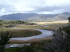
 Darby River, as it meanders, looking north east from the foot of Darby Hill | |
| Location | |
| Country | Australia |
| State | Victoria |
| Region | South East Coastal Plain (IBRA), South Gippsland |
| Local government area | South Gippsland Shire |
| Physical characteristics | |
| Source | Latrobe Range |
| • location | below Mount Latrobe |
| • coordinates | 38°59′10″S 146°20′19″E |
| • elevation | 310 m (1,020 ft) |
| Mouth | Whisky Bay, Bass Strait |
• location | Wilsons Promontory |
• coordinates | 38°58′19″S 146°16′3″E |
• elevation | 0 m (0 ft) |
| Length | 7 km (4.3 mi) |
| Discharge | |
| • location | mouth |
| Basin features | |
| River system | West Gippsland catchment |
| National park | Wilson's Promontory NP |
| [1] | |
Location and features
The Darby River rises below Mount Latrobe, part of the Latrobe Range, north of Wilsons Promontory and flows generally west by southwest before reaching its river mouth and emptying into Whisky Bay within Bass Strait in the South Gippsland Shire. The river descends 301 metres (988 ft) over its combined 7-kilometre (4.3 mi) course.[1] The river is in relatively pristine condition, with the only human interference being a bridge at the estuary. Native fish species include common galaxias, pouched lamprey, short-finned eel, tupong, flat-headed gudgeon and southern pigmy perch.[2]
The Darby River is contained entirely within the Wilson's Promontory National Park. The park entrance, ranger station and accommodation centre was located near Darby River from 1909 until World War II.[3] These facilities moved to Tidal River thereafter.[4]
The river is traversed by the Wilsons Promontory Road near the river mouth.[1] Heavy rains in March 2011 caused unprecedented flooding of the river, damaging the bridge carrying the Wilsons Promontory Road over the river; and stranding hundreds of campers who had to be evacuated by helicopter.[5]
References
- "Map of Darby River, VIC". Bonzle Digital Atlas of Australia. Retrieved 26 February 2014.
- "Estuary Assessment Framework for Non-Pristine Estuaries: Estuary 917 (Darby River)" (PDF). Australia's Online Coastal Information. Geoscience Australia. Retrieved 26 February 2014.
- Garnet, J. Roslyn; Synan, Terry; Catrice, Daniel. "A History of Wilsons Promontory" (PDF). Victorian National Parks Association.
- "No. 7 Infantry Training Centre For Commandos". Australia @ War. Peter Dunn. 2 September 2007. Retrieved 26 February 2014.
- "Campers to be evacuated after bridge collapses". ABC News. Australia. 23 March 2011. Retrieved 26 February 2014.
External links
- "West Gippsland Regional Catchment Strategy (2013 - 2019)" (PDF – 4MB). West Gippsland Catchment Management Authority. 2012. ISBN 978-0-9805562-8-5.
- "Latrobe Catchment Ecosystem" (PDF). West Gippsland Catchment Management Authority. 2012. Archived from the original (PDF) on 6 April 2011.
