Wye River (Victoria)
The Wye River is a perennial river of the Corangamite catchment, located in The Otways region of the Australian state of Victoria.
| Wye | |
|---|---|
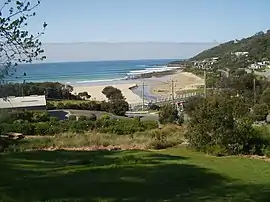 The estuary of the Wye | |
| Etymology | River Wye[1] |
| Location | |
| Country | Australia |
| State | Victoria |
| Region | South East Coastal Plain (IBRA), The Otways |
| LGA | Colac Otway Shire |
| Physical characteristics | |
| Source | Otway Ranges |
| • coordinates | 38°36′3″S 143°47′44″E |
| • elevation | 601 m (1,972 ft) |
| Mouth | Bass Strait |
• location | Wye River (town) |
• coordinates | 38°37′49″S 143°50′48″E |
• elevation | 0 m (0 ft) |
| Length | 11 km (6.8 mi) |
| Basin features | |
| River system | Corangamite catchment |
| National park | Great Otway National Park |
| [2][3] | |
Location and features
The Wye River rises in the Otway Ranges in southwest Victoria and flows generally east towards the town of Wye River where the river reaches its mouth and empties into Bass Strait, north of Cape Otway. From its highest point, the river descends 601 metres (1,972 ft) over its 11-kilometre (6.8 mi) course.[3]
Etymology
The river was named by surveyor George Smythe and is derived from one of the rivers of the same name in the United Kingdom.[1]
References
- Bird, Eric (12 October 2006). "Place Names on the Coast of Victoria" (PDF) (PDF). Australian National Placename Survey (ANPS). Archived from the original (PDF) on 10 February 2011.
- "Wye River: 8932". Vicnames. Government of Victoria. 2 May 1966. Retrieved 1 June 2014.
- "Map of Wye River, VIC". Bonzle Digital Atlas of Australia. Retrieved 1 June 2014.
External links
- "Great Otway National Park". Parks Victoria. Government of Victoria. 2014.
- "Corangamite Catchment Management Authority". Government of Victoria. 2014.
Rivers of the Corangamite catchment, Victoria, Australia | |
|---|---|
|
This article is issued from Wikipedia. The text is licensed under Creative Commons - Attribution - Sharealike. Additional terms may apply for the media files.