Darfield, New Zealand
Darfield is a town in the Selwyn District of the South Island of New Zealand. It is 35 kilometres west of the outskirts of Christchurch. Its population is 2,960 as of June 2020.[2]
Darfield | |
|---|---|
 Darfield sign on New Zealand State Highway 73, the main street of Darfield | |
 Darfield | |
| Coordinates: 43°29′S 172°07′E | |
| Country | |
| Region | Canterbury |
| Territorial authority | Selwyn District |
| Electorates | Selwyn Te Tai Tonga[1] |
| Population (June 2020)[2] | |
| • Total | 2,960 |
| Time zone | UTC+12 (NZST) |
| • Summer (DST) | UTC+13 (NZDT) |
| Postcode(s) | 7510 |
| Area code(s) | 03 |
| Local iwi | Ngāi Tahu |
Darfield is the main town between Christchurch and the West Coast region. It is often called "The township under the nor'west arch" in reference to a characteristic weather phenomenon that often creates an arch of cloud in an otherwise clear sky to the west of the township. This is caused by the condensation of water particles channelled upwards over the Southern Alps.
Darfield lies in the Malvern district's arable and pastoral farming area. It is a gateway to the scenic Waimakariri and Rakaia rivers and the Southern Alps, and is also a popular lift-off place for hot air ballooning.
Darfield is located near the junction of the railway lines coming from Christchurch and going to Whitecliffs (where coal was mined) and Springfield and on to the west coast.
History
Darfield was first known as White Cliffs Junction it was renamed in 1879 as Horndon Junction, which was changed to avoid confusion with Hornby [railway] Junction (close by in Christchurch).
Darfield acquired its name from John Jebson who named it after the village in Yorkshire, England. The name refers to a field frequented by deer.[3]
A stone mill for grinding flour was built in 1887. It was powered by the Selwyn County Council's water race.
A magnitude 7.1 earthquake occurred near Darfield at 4:35 am on 4 September 2010, causing widespread damage to both the town and to surrounding areas including the city of Christchurch.[4]
Fonterra invested $500 million in a milk processing plant which was opened in 2013 in Darfield. This includes the world's largest dryer which is used in the process to make instant wholemilk powder.[5][6]
Climate
Located on the Canterbury Plains at an altitude of 193 metres (633 feet) above sea level, the Köppen-Geiger climate classification for Darfield is Cfb (Oceanic). On several days a year, Darfield is subject to the nor'west Foehn wind, which is very dry and has the capability to raise the temperature by several degrees per hour. On the contrary, the town is also susceptible to cold blasts from the Southern Ocean, especially during winter, when a southerly wind blows. The average annual temperature in Darfield is 11.6°C (52.9°F). The highest recorded temperature is 40.7°C (105.3°F), set on 8 February 1973, while the lowest recorded temperature is -8.0°C (17.6°F), set on 7 June 2012. The highest minimum temperature is 25.7°C (78.3°F), set on 6 February 2011, while the lowest maximum temperature is 0.6°C (33.1°F), set on 12 July 2017. On average, Darfield can expect to see 38.3 days of frost per year, and 49 days where the maximum temperature exceeds 26.7°C (80°F).
| Climate data for Darfield, 193 m | |||||||||||||
|---|---|---|---|---|---|---|---|---|---|---|---|---|---|
| Month | Jan | Feb | Mar | Apr | May | Jun | Jul | Aug | Sep | Oct | Nov | Dec | Year |
| Record high °C (°F) | 38.4 (101.1) |
40.7 (105.3) |
37.6 (99.7) |
31.4 (88.5) |
27.2 (81.0) |
22.3 (72.1) |
20.5 (68.9) |
23.3 (73.9) |
27.8 (82.0) |
30.0 (86.0) |
31.9 (89.4) |
36.5 (97.7) |
40.7 (105.3) |
| Average high °C (°F) | 23.0 (73.4) |
22.7 (72.9) |
20.6 (69.1) |
17.4 (63.3) |
14.4 (57.9) |
11.4 (52.5) |
10.9 (51.6) |
12.3 (54.1) |
14.8 (58.6) |
17.0 (62.6) |
19.1 (66.4) |
21.3 (70.3) |
17.1 (62.8) |
| Daily mean °C (°F) | 16.9 (62.4) |
16.5 (61.7) |
14.9 (58.8) |
12.0 (53.6) |
9.3 (48.7) |
6.6 (43.9) |
6.2 (43.2) |
7.3 (45.1) |
9.5 (49.1) |
11.4 (52.5) |
13.2 (55.8) |
15.4 (59.7) |
11.6 (52.9) |
| Average low °C (°F) | 10.8 (51.4) |
10.6 (51.1) |
9.4 (48.9) |
6.6 (43.9) |
4.3 (39.7) |
2.0 (35.6) |
1.6 (34.9) |
2.4 (36.3) |
4.2 (39.6) |
5.8 (42.4) |
7.4 (45.3) |
9.6 (49.3) |
6.2 (43.2) |
| Record low °C (°F) | 0.6 (33.1) |
1.6 (34.9) |
0.3 (32.5) |
−0.3 (31.5) |
−2.1 (28.2) |
−8.0 (17.6) |
−6.4 (20.5) |
−3.1 (26.4) |
−2.6 (27.3) |
−2.2 (28.0) |
−1.2 (29.8) |
0.2 (32.4) |
−8.0 (17.6) |
| Average rainfall mm (inches) | 60.3 (2.37) |
51.1 (2.01) |
60.5 (2.38) |
78.8 (3.10) |
58.1 (2.29) |
61.8 (2.43) |
59.4 (2.34) |
68.1 (2.68) |
46.7 (1.84) |
67.6 (2.66) |
54.6 (2.15) |
63.9 (2.52) |
730.9 (28.78) |
| Source 1: Climate-data.org[7] | |||||||||||||
| Source 2: weatherbase.com[8] | |||||||||||||
Demographics
The population of Darfield was 830 people in 1971.[9] In 2006, Darfield had a population of 1974, growing to 2397 in 2013 and 2724 in 2018. The median age of the residents in 2018 was 43.9 years old. In terms of ethnicity, 94.6% of residents identified as European, 6.6% identified as Maori and 8.9% identified as of Maori descent. The majority of residents were born in New Zealand (83.7%). The majority of residents identified with no religion (52.5%) while a sizeable minority (38.3%) identified as Christian. The majority of residents (51.7%) were in full time employment. The median income was $36,400 with 20.3% earning over $70,000.[10]
In 2018, there were 1059 occupied private dwellings and a further 63 unoccupied private dwellings.[10]
Education
Darfield has numerous kindergartens. The original Darfield school was opened in 1883 with a total of 18 students attending. by 1902 the school had two teachers and ninety-three students children on the school roll.[11]
Darfield Primary School is Darfield's sole primary school.
Darfield High School is Darfield's sole intermediate/highschool. The role was steady at approximately 700 students in 2015.[6]
Industry
Many industries are present in Darfield, including brick-making, seed cleaning, and a Fonterra factory, which processes milk powder. The factory has a series of railway sidings and a container loading centre.[12]
Services

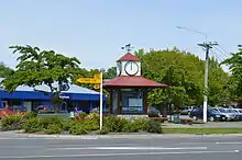
Darfield has a shopping precinct along the main street, including a Four Square Supermarket. The town also has many churches, most notably St Joseph's Catholic Church and Trinity Church (Anglican, Methodist, Presbyterian). Darfield has two resthomes.
Other services include: a bakery, bank, cafés and bars, hotels, a library, motels, numerous petrol stations, a post office, and a veterinary clinic.
Darfield is also has a police, fire and ambulance stations, as well as a medical centre and a hospital.
Selwyn is not connected to a district wide sewage scheme. this necessitates all homes to have their own septic tanks.[6]
Recreation
Darfield has a domain, which includes duck ponds and the community centre. Football and rugby fields, tennis courts and a Scouts building are also located in the domain.
McHughs Forest Park is located just north of Darfield. It was planted in 1893 to provide timber for mid Canterbury. It contains a mix of Douglas Fir, Pinus Radiata, Macrocarpa, Larch, Spruce and other exotic species. There are a series of walking tracks within the forest.
Transport
Bus
Darfield is serviced with the 86 bus route, a morning and evening express route that connects the town with Central Christchurch, via Kirwee, West Melton and Yaldhurst.[13]
Rail
Darfield is served by the Midland railway line. The TranzAlpine train stops twice daily; en route to the West Coast and on its return trip.
Road
Darfield is served by State Highway 73 (Great Alpine Highway), connecting Christchurch with the West Coast region and State Highway 77, connecting Darfield with Ashburton via Methven, the Rakaia Gorge and Glentunnel.
Notable people
- John Wright (5 July 1954), New Zealand cricketer and former coach of the Indian national cricket team
- Mary Clinton (8 May 1960), New Zealand field hockey player
- Brian Connell (23 April 1956), politician
- James Te Huna (29 September 1981), first New Zealander to enter the UFC, 2010 (Ultimate Fighting Championships)
Gallery
 St Joseph's Catholic Church, October 2013
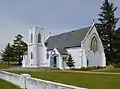
 Trinity Church, October 2013
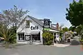 Cafe in central Darfield, October 2013
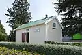 Historic jail dating 1915, October 2013
 Darfield War Memorial, located next to Trinity Church, October 2013
References
- "Archived copy". Archived from the original on 8 February 2013. Retrieved 20 December 2016.CS1 maint: archived copy as title (link)
- "Population estimate tables - NZ.Stat". Statistics New Zealand. Retrieved 22 October 2020.
- "Darfield | NZHistory, New Zealand history online". nzhistory.govt.nz. Retrieved 27 November 2020.
- Booker, Jarrod (4 September 2010). ""Extremely violent" 7.4 quake hits Christchurch". The New Zealand Herald.
- "Fonterra sinking millions into South Island". Stuff. 14 November 2014. Retrieved 27 November 2020.
- "Small town life: Does Darfield need a gimmick to put itself on the map?". Stuff. 8 August 2015. Retrieved 27 November 2020.
- | "Climate-data.org – Climate Data for Cities Worldwide". openstreetmap.org. Retrieved 22 December 2020.
- /ref> "Weatherbase". CantyMedia. Retrieved 22 December 2020.
- Taonga, New Zealand Ministry for Culture and Heritage Te Manatu. "Darfield district". teara.govt.nz. Retrieved 27 November 2020.
- "2018 Census place summaries | Stats NZ". stats.govt.nz. Retrieved 16 October 2020.
- "Darfield | NZETC". nzetc.victoria.ac.nz. Retrieved 27 November 2020.
- "KiwiRail opens South Island Freight Link". International Railway Journal. 20 April 2013.
- "Darfield/City | Metro Christchurch". metroinfo.co.nz. Retrieved 21 September 2020.
External links
| Wikimedia Commons has media related to Darfield, New Zealand. |