West Melton, New Zealand
West Melton is a town located west of Christchurch in the Canterbury region of New Zealand's South Island.
West Melton | |
|---|---|
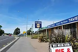 West Melton Tavern | |
 West Melton | |
| Coordinates: 43°31′S 172°22′E | |
| Country | New Zealand |
| Region | Canterbury |
| Territorial authority | Selwyn District |
| Electorates | Selwyn Te Tai Tonga |
| Area | |
| • Total | 5.32 km2 (2.05 sq mi) |
| Elevation | 88 m (289 ft) |
| Population (2018) | |
| • Total | 2,085 |
| • Density | 390/km2 (1,000/sq mi) |
| Time zone | UTC+12 (New Zealand Standard Time) |
| • Summer (DST) | UTC+13 (New Zealand Daylight Time) |
| Local iwi | Ngāi Tahu |
History
West Melton was first settled in the 1870's and has recently grown significantly with the addition of housing developments. It has long been associated with horse racing (trotting), arable land, and sheep farming. Recently, it has become associated with wine growing and deer farming and has become popular for premium housing developments.
Demographics
West Melton had a population of 2,085 at the 2018 New Zealand census, an increase of 1,305 people since the 2013 census. There were 1,017 males and 1,068 females. 94% were European/Pākehā, 5.9% were Māori, 5.2% were Asian, 0.9% were Pacific peoples, 0.6% MELAA and 1.7% were other ethnicities.[1]
West Melton and the Selwyn District are two of the fastest growing areas in New Zealand with regards to population, and economic progression.
Services
West Melton has a shopping precinct including a Four Square supermarket, community centre and a domain, as well as a primary school. West Melton Aerodrome is located in the area as is the Canterbury Astronomical Society.
Transport
Bus
West Melton is serviced with the 86 bus route, a morning and evening express route that connects Darfield with the Central Christchurch.[2]
Road
West Melton is accessed by State Highway 73 which pass through the centre of the town. West Melton is also closely linked to the newly built extension of the Christchurch Southern Motorway via Weedons Ross Road.
West Melton's first set of traffic lights is set to be installed in 2022-2023.[3]
References
- "2018 Census place summaries | Stats NZ". www.stats.govt.nz. Retrieved 22 September 2020.
- "Darfield/City | Metro Christchurch". www.metroinfo.co.nz. Retrieved 21 September 2020.
- "Canterbury package | Waka Kotahi NZ Transport Agency". www.nzta.govt.nz. Retrieved 30 September 2020.