Glentunnel
Glentunnel (previously known as Surveyors Gully) is a village located in the Selwyn District of the Canterbury region of New Zealand's South Island.
Glentunnel | |
|---|---|
Village | |
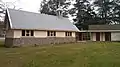
 Brethren Chapel in Glentunnel, November 2011 | |
 Glentunnel | |
| Coordinates: 43°29′S 171°56′E | |
| Country | New Zealand |
| Region | Canterbury |
| Territorial authority | Selwyn District |
| Electorates | Selwyn Te Tai Tonga |
| Elevation | 260 m (850 ft) |
| Population (2018) | |
| • Total | 1,191 |
| Time zone | UTC+12 (New Zealand Standard Time) |
| • Summer (DST) | UTC+13 (New Zealand Daylight Time) |
| Postcode | 7673 |
| Area code(s) | 03 |
It is officially recognised as a locality by LINZ.[1] The 2018 New Zealand census gave Glentunnel's population as 1,191[2][lower-alpha 1]. It is located on State Highway 77 and the tourist route Inland Scenic Route 72. Glentunnel is 260 meters above sea-level.[3]
History
1800's-2000's
Glentunnel was served by the Whitecliffs Branch, a branch line railway, from the line's opening on 3 November 1875 through to its closure on 31 March 1962. However, the station was not open until 22 April 1876. Few remnants of the railway remain in the town, with the station's platform incorporated into the backyard of a private residence.[4]
An Anglican church used to be situated on the corner of State Highway 77 and Victoria Street, but it caught fire and was demolished. These grounds have also been incorporated into a private residence.
2010 Canterbury earthquake
The historic Homebush Homestead, located four kilometres east from Glentunnel was extensively damaged by the 2010 Canterbury earthquake, so much so that it has been described as being "practically in ruins".[5] It was later demolished and a new homestead was built on the same site.[6]
Five kilometres south in Hororata, the historic St John's Church, built in 1911 had its bell tower partially collapsed, causing damage to the nave and destroying the organ.[7]
Ecology
Joyce Reserve is a part of a Canterbury Plain-wide vision for a network of native forest. A total of 100,000 native trees have been planted by local school children and other volunteers. The aim is to encourage native birds to repopulate the region, as well as have a safe 'green path' from the Southern Alps to Lake Ellesmere, in between the two rivers (Rakaia and Waimakariri). Thus far, kingfishers, bellbirds, and waxeyes have inhabited the area.[8]
Education
Glentunnel Primary School is Glentunnel's sole primary school.
Industry
Industrial activity such as lignite coal mining and the manufacture of pottery and bricks used to take place in the region around Glentunnel. This was one reason as to why the railway was built, but industrial activity declined sharply in the 20th century and has been effectively non-existent since the 1980s.[9] However, one open-pit coal mine is still operated by Bathurst coal Ltd.[10]
Services
Glentunnel has a general store. Two churches are also located here: a Brethren Church and a combined denominational church of Anglican, Methodist and Presbyterian. Cafés, a community centre, garage, library, museum, playground and a post office are also located in the village.
Recreation
Glentunnel has many recreational walkways. These include the River Walk, a walkway that follows the Selwyn River from the camping ground to the one-lane bridge at the western end of Glentunnel, and the Millennium Walkway, which follows a now, non-existent tramway route up to the disused tunnel which gave the township its name.[11] This walkway was opened in 2000.
Glentunnel also has a domain, where cricket, football or rugby can be played. To the south of the domain is the Glentunnel camping ground, which is popular during the summer months for its location next to the Selwyn River.
Adjacent to the domain is the Hororata Golf Club.
Gallery
 St Andrews of the Glen
 Historic octagonal brick library and post office. Original gate located in the foreground.
Footnotes
- Total population includes the urban areas of Coalgate, Homebush and Whitecliffs.
Bibliography
David Leitch and Brian Scott, Exploring New Zealand's Ghost Railways, revised edition (Wellington: Grantham House, 1998 [1995]), 71-2.
References
- "NZGB Gazetteer | linz.govt.nz". gazetteer.linz.govt.nz. Retrieved 1 August 2020.
- "2018 Census place summaries | Stats NZ". www.stats.govt.nz. Retrieved 26 April 2020.
- "Glentunnel" (PDF). Selwyn District Council. Retrieved 24 May 2020.
- David Leitch and Brian Scott, Exploring New Zealand's Ghost Railways, revised edition (Wellington: Grantham House, 1998 [1995]), 71-2.
- "Quake destroys historic homestead". The New Zealand Herald. 5 September 2010. Retrieved 1 October 2011.
- "History revisited at Homebush". Stuff. 23 October 2014. Retrieved 1 August 2020.
- "Hororata – St John's Anglican Church". Hunting Kiwis. 5 October 2013. Retrieved 1 August 2020.
- "100,000th native tree planted in mini forest scheme in Canterbury". Stuff. 14 September 2020. Retrieved 8 November 2020.
- "Glentunnel and Coalgate". Selwyn District Council. Retrieved 17 June 2020.
- Bolger, Devon (1 July 2020). "Planned coal mine expansion subject of meeting". Otago Daily Times Online News. Retrieved 5 July 2020.
- "glentunnel millennium walk". Foursquare. Retrieved 1 August 2020.
External links
![]() Media related to Glentunnel at Wikimedia Commons
Media related to Glentunnel at Wikimedia Commons