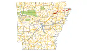
Arkansas Highway 18
Highway 18 (AR 18 and Hwy. 18) is an east–west state highway of 93.43 miles (150.36 km) in Northeast Arkansas.[1][2][3][4]
| ||||
|---|---|---|---|---|
 | ||||
| Route information | ||||
| Maintained by ArDOT | ||||
| Length | 93.43 mi[1][2][3][4] (150.36 km) | |||
| Existed | April 1, 1926[5]–present | |||
| Major junctions | ||||
| West end | ||||
| ||||
| East end | Mississippi River, Tennessee state line | |||
| Location | ||||
| Counties | Jackson, Poinsett, Craighead, Mississippi | |||
| Highway system | ||||
| ||||

Route description
AR 18 begins at AR 69 near Jacksonport. Brief concurrencies begins with AR 17 and US 67 (Future I-57) in Newport, and Arkansas Highway 18S leads to Newport Municipal Airport as AR 18 continues east. The route runs east to AR 37 in Grubbs before turning north at Uno to AR 226 in Cash. AR 18 joins AR 91 and becomes King's Highway.
AR 18/AR 91 run together with US 63 into Jonesboro. AR 18 breaks and runs as Highland Dr., meeting US 49/AR 1. After Jonesboro, AR 18 meets AR 158 and AR 135 in Lake City. The three routes continue east to Black Oak, when AR 18 turns north. AR 18 briefly runs with AR 139 in Monette before continuing east. AR 18B is created in Manila, and AR 18 meets AR 77.
The route briefly meets AR 181 near Dell before turning northeast to Blytheville. AR 18 meets AR 151 and US 61 in downtown Blytheville. The route continues east to cross over Interstate 55 (exit 67) in a frontage road interchange. AR 18 and AR 312 meet briefly south of the Blytheville Municipal Airport. The route continues to terminate at the Mississippi River at the Tennessee state line.
Major intersections
Mile markers reset at some concurrencies.
| County | Location | mi | km | Destinations | Notes |
|---|---|---|---|---|---|
| Jackson | | 0.000 | 0.000 | ||
| Diaz | 0.931 | 1.498 | West end of AR 17 overlap | ||
| 0.000 | 0.000 | Southern terminus of AR 17; east end of AR 17 overlap | |||
| Newport–Diaz line | |||||
| US 67 exit 85 | |||||
| Newport | |||||
| | |||||
| | |||||
| Grubbs | West end of AR 37 overlap | ||||
| | East end of AR 37 overlap | ||||
| Poinsett | Uno | ||||
| Craighead | Cash | ||||
| Three Way | 30.582 | 49.217 | West end of AR 91 overlap | ||
| Herman | |||||
| Jonesboro | East end of AR 91 overlap; west end of I-555/US 63 overlap; AR 18 west follows exit 49 | ||||
| Washington Avenue | US 63 exit 47 | ||||
| US 63 exit 46 | |||||
| 0.000 | 0.000 | East end of I-555/US 63 overlap; AR 18 east follows exit 45 | |||
| Former US 49B north; west end of CRP overlap | |||||
| East end of CRP overlap | |||||
| South Caraway Road | Former AR 173 | ||||
| Lake City | |||||
| West end of AR 135 overlap | |||||
| Black Oak | East end of AR 135 overlap | ||||
| Monette | West end of AR 139 overlap | ||||
| East end of AR 139 overlap | |||||
| Mississippi | Leachville | ||||
| Manila | |||||
| 35.096 | 56.482 | West end of AR 77 overlap | |||
| East end of AR 77 overlap | |||||
| | |||||
| Dell | |||||
| | |||||
| | |||||
| Blytheville | West end of AR 151 overlap | ||||
| 53.160 | 85.553 | ||||
| 55.730 | 89.689 | I-55 exit 67 | |||
| East end of AR 151 overlap | |||||
| | |||||
| | |||||
| Barfield | 62.249 | 100.180 | End State Maintenance | ||
1.000 mi = 1.609 km; 1.000 km = 0.621 mi
| |||||
History
Highway 18 was created during the 1926 Arkansas state highway numbering from Diaz to Barfield similar to the present-day alignment.[5] The designation was shifted onto Nettleton Cut-Off Road in Jonesboro on March 9, 1955.[6] The highway was rerouted between Leachville and Manilla on July 10, 1957, with Highway 18 taking over the former alignment of Highway 18 Spur.[7] It was extended to Barfield Landing on April 24, 1963 as part of a major expansion of the state highway system.[8] The western terminus was extended west to Highway 69 in Jacksonport on November 23, 1966.[9]
Auxiliary routes
See also
References
- Arkansas State Highway and Transportation Department. AHTD Jackson County map Retrieved on August 27, 2009.
- Arkansas State Highway and Transportation Department. AHTD Poinsett County map Retrieved on August 27, 2009.
- Arkansas State Highway and Transportation Department. AHTD Craighead County map Retrieved on August 27, 2009.
- Arkansas State Highway and Transportation Department. AHTD Mississippi County map Retrieved on August 27, 2009.
- Arkansas State Highway Department (April 1, 1926). State of Arkansas Showing System of State Highways (TIF) (Map). 1:500,000. Little Rock: Arkansas State Highway Commission. Retrieved December 23, 2017 – via Arkansas GIS Office.
- "Minutes of the Meeting of the Arkansas State Highway Commission" (PDF). Little Rock: Arkansas State Highway Commission. 1953–1969. pp. 1964–1965. OCLC 21798861. Retrieved November 28, 2020.
- "Minutes" (1953–69), p. 1789.
- "Minutes" (1953–69), pp. 913-916.
- "Minutes" (1953–69), p. 561.
External links
![]() Media related to Arkansas Highway 18 at Wikimedia Commons
Media related to Arkansas Highway 18 at Wikimedia Commons
