Dhanusha District
Dhanusha District, (Nepali: धनुषा जिल्ला; [dʱʌnusa] (![]() listen)), a part of Province No. 2, is one of the seventy-seven districts of Nepal.[2] It is situated in the Outer Terai. The district, with Janakpur as its district headquarter, covers an area of 1,180 km2 (460 sq mi) and has a population (2011) of 754,777.[1]
listen)), a part of Province No. 2, is one of the seventy-seven districts of Nepal.[2] It is situated in the Outer Terai. The district, with Janakpur as its district headquarter, covers an area of 1,180 km2 (460 sq mi) and has a population (2011) of 754,777.[1]
Dhanusha District
धनुषा जिल्ला | |
|---|---|
District | |
 Janaki Temple at Dhanusha District | |
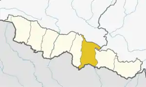 Dhanusha District (dark yellow) in Province No. 2 | |
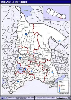
 Dhanusha District with local level body | |
| Country | |
| Province | Province No. 2 |
| Admin HQ. | Janakpur |
| Government | |
| • Type | Coordination committee |
| • Body | DCC, Dhanusha |
| Area | |
| • Total | 1,180 km2 (460 sq mi) |
| Population (2011)[1] | |
| • Total | 754,777 |
| • Density | 640/km2 (1,700/sq mi) |
| Time zone | UTC+05:45 (NPT) |
| Main Language(s) | Maithili (85.8%), Nepali (4.5%) |
| Website | ddcdhanusha |
During the elections in April 2008, the district was divided into seven constituencies. It is also the home district of the first president of Nepal, Dr. Ram Baran Yadav, who contested and won the elections from constituency 5. As a political center of the region, it has prominent leaders like Bimalendra Nidhi from the Nepali Congress, Anand Yadav (Gangaram Yadav) from the CPN-UML, Matrika Yadav, and Suryanath Ran Yadav from the CPN-Maoist.
The most common language spoken in Dhanusha is Maithili.
Tourist attriactions in Dhanusa include its temples and ponds, mostly situated in Janakpur. These include the Janaki Temple, Dhanusadham, where according to Hindu mythology, a part of Shiva's bow that Lord Ram broke is said to have fallen. A Mithila Women's Art Center is also a tourist attraction in the area.
Dhanusha district has an airport and the only railway system of Nepal which connects Janakpurdham with an Indian town, Jayanagar. It has several good hotels like Hotel Rama, Hotel Sita Palace, including the starred hotel, Hotel Welcome, Sitasaran hotel and Happy hotel.[3] It also has the Janakpur Zonal Hospital and several private hospitals.
Geography and climate
| Climate Zone[4] | Elevation Range | % of Area |
|---|---|---|
| Lower Tropical | below 300 meters (1,000 ft) | 92.5% |
| Upper Tropical | 300 to 1,000 meters 1,000 to 3,300 ft. |
7.5% |
Economy
Agriculture is the major economy of Dhanusha district. About 90% of citizens of this district are involved in the cultivation of wheat and rice. Rice is the major output. Dhanusha still relies mostly on old age techniques such as bullock-cart for transportation and bull plow for tilling the agriculture fields. However, there is a slow introduction to modern techniques such as a tractor for good transportation (for agriculture purposes), thrasher, and so on. Remittances make up a large portion of its GDP.[5]
Demographics
At the time of the 2011 Nepal census, Dhanusha District had a population of 754,777. Of these, 85.8% spoke Maithili, 4.5% Nepali, 3.1% Magahi, 2.4% Urdu, 1.1% Tamang and 0.9% Magar as their first language.
36.2% of the population in the district spoke Nepali, 9.5% Hindi, 2.9% Maithili, 1.1% Urdu and 1.0% Magahi as their second language.[6]
Administration

The district consists of one sub-metropolitan city, eleven urban municipalities and six rural municipalities. These are as follows:
- Janakpur Sub Metropolitan City
- Chhireshwarnath Municipality
- Ganeshman Charanath
- Dhanusadham Municipality
- Nagarain Municipality
- Bideha Municipality
- Mithila Municipality
- Sahidnagar Municipality
- Sabaila Municipality
- Kamala Municipality
- Mithila Bihari Municipality
- Hansapur Municipality
- Janaknandani Rural Municipality
- Bateshwar Rural Municipality
- Mukhiyapatti Musharniya Rural Municipality
- Lakshminya Rural Municipality
- Aurahi Rural Municipality
- Dhanauji Rural Municipality
Former municipalities and VDCs
- Andupatti
- Aurahi
- Baphai
- Bagchaura
- Baheda Bala
- Bahuarba
- Balabakhar
- Balaha Kathal
- Balaha Saghara
- Ballagoth
- Baniniya
- Baramajhiya
- Basahiya
- Basbitti
- Bateshwar
- Bega Shivapur
- Begadawar
- Bharatpur
- Bhuchakrapur
- Bhutahi Paterwa
- Bindhi
- Bisarbhora
- Chakkar
- Chireswarnath
- Chora Koilpur
- Debadiha
- Deuri Parbaha
- Devpura Rupetha
- Dhabauli
- Dhalkebar
- Dhanauji
- Dhanusadham Municipality
- Dubarikot Hathalekha
- Duhabi
- Ekarahi
- Ganeshman Charanath Municipality
- Ghodghans
- Giddha
- Godar
- Gopalpur
- Goth Kohelpur
- Hansapur Kathpula
- Harine
- Hathipur Harbara
- Inarwa
- Itaharwa
- Janakpur Sub Metropolis
- Jhatiyahi
- Jhojhi Kataiya
- Kachuri Thera
- Kajara Ramaul
- Kanakpatti
- Khajuri Chanha
- Khariyani
- Kurtha
- Labatoli
- Lagmamdha Guthi
- Lakhauri
- Lakkad
- Lakshminibas
- Lakshmipur Bagewa
- Lohana Bahbangama
- Machijhitakaiya
- Mahuwa (Pra. Ko)
- Mahuwa (Pra. Khe)
- Makhanaha
- Manshingpatti
- Mithileshwar Nikash
- Mithileshwar Mauwahi
- Mithila Municipality
- Mukhiyapatti Mushargiya
- Nagarain
- Nakatajhijh
- Nauwakhor Prashahi
- Nunpatti
- Pachaharwa
- Papikleshwar
- Patanuka
- Paterwa
- Paudeshwar
- Phulgama
- Puspalpur
- Raghunathpur
- Rampur Birta
- Sabaila Municipality
- Sapahi
- Satosar
- Shantipur
- Siddha
- Singyahi Maidan
- Sinurjoda
- Sonigama
- Suga Madhukarahi
- Suganikash
- Tarapatti Sirsiya
- Thadi Jhijha
- Thilla Yaduwa
- Tulsi Chauda
- Tulsiyahi Nikas
- Tulsiyani Jabdi
- Yadukush
- Yagyabhumi
References
- "National Population and Housing Census 2011(National Report)" (PDF). Central Bureau of Statistics. Government of Nepal. November 2012. Archived from the original (PDF) on 18 April 2013. Retrieved 1 November 2012.
- "Districts of Nepal". Statoids.
- "Registered Star Hotels". Government of Nepal, Ministry of Tourism and Civil Aviation, Tourism Industry Division. Archived from the original on 12 April 2010. Retrieved 9 August 2010.
- The Map of Potential Vegetation of Nepal – a forestry/agroecological/biodiversity classification system (PDF), Forest & Landscape Development and Environment Series 2-2005 and CFC-TIS Document Series No.110., 2005, ISBN 87-7903-210-9, retrieved 22 November 2013
- "A Case Study of Dhanusha District" (PDF). Impact Evaluation of Remittances. n.d.
- 2011 Nepal Census, Social Characteristics Tables
External links
| Wikimedia Commons has media related to Dhanusha District. |
- Dhanusa District map at Digital Himalaya
- Nepal Maps
Places adjacent to Dhanusha District | ||||||||||
|---|---|---|---|---|---|---|---|---|---|---|
| ||||||||||