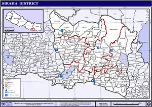
Siraha District
Siraha District (Nepali: सिराहा जिल्ला![]() Listen , a district in Province No. 2, is one of the seventy-seven districts of Nepal. It is situated in the Terai belt of Nepal. The district, with Siraha as its district headquarters, covers an area of 1,188 km2 (459 sq mi). It has population of 637,328 according to census of 2011. Majority of the population here is Yadav, Tharus, Muslims and ethnic minorities with majority population speaking Maithili language and Nepali language.
Listen , a district in Province No. 2, is one of the seventy-seven districts of Nepal. It is situated in the Terai belt of Nepal. The district, with Siraha as its district headquarters, covers an area of 1,188 km2 (459 sq mi). It has population of 637,328 according to census of 2011. Majority of the population here is Yadav, Tharus, Muslims and ethnic minorities with majority population speaking Maithili language and Nepali language.
Siraha District
सिराहा जिल्ला | |
|---|---|
District | |
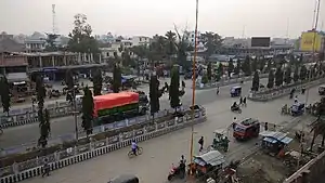 Lahan Bazar in Siraha District | |
 Siraha District (dark yellow) in Province No. 2 | |
 Siraha District with local level body | |
| Country | |
| Province | Province No. 2 |
| Admin HQ. | Siraha |
| Government | |
| • Type | Coordination committee |
| • Body | DCC, Siraha |
| Area | |
| • Total | 1,188 km2 (459 sq mi) |
| Population (2011) | |
| • Total | 637,328 |
| • Density | 540/km2 (1,400/sq mi) |
| Time zone | UTC+05:45 (NPT) |
| Website | ddcsiraha |
Lahan is the biggest city and is popular for Sagarmatha Chaudhary Eye Hospital. It lies in Mahendra highway.
Thadi (Nepali: ठाड़ी) or Thadi Viswaspatti is the main entry point for the district form India and a very old border town and a market place of Nepal in Siraha District bordering Indian town of Laukaha.
Thadi is one of the few towns which is a part of agreed route for Mutual Trade between India and Nepal.[1] Nepal Government has set up a dedicated customs office in the town.[2]
The town connects Lahan to India.
Infrastructure
There are no airports in this district but Rajbiraj Airport in nearby Saptari district is the nearest airport to the district, roughly 28–58 km away from various locations. Shree Airlines operates daily flights between Rajbiraj and Kathmandu[3]
Thadi in Siraha is a part of one of the agreed route for Mutual Trade and custom point between India and Nepal.[4] Nepal Government has set up a dedicated customs office in the town[5] and Government of India has set up a Land Customs Station.[6] So in simple import and export are allowed through this point.
The largest town is Lahan, where there is a popular eye hospital called Sagarmatha Choudhary Eye Hospital, Lahan.
Transportation
The district is well connected with Mahendra Highway as this national Highway passes right through the district while connecting all the major towns. Other rural municipalities are also well connected by Postal Highway which is under construction and taking shape rapidly. Another major project i.e. East-West Railway also will run through this district in future and is in the process of development.
Geography and Climate
| Climate Zone[7] | Elevation Range | % of Area |
|---|---|---|
| Lower Tropical | below 300 meters (1,000 ft) | 90.5% |
| Upper Tropical | 300 to 1,000 meters 1,000 to 3,300 ft. |
9.5% |
Demographics
At the time of the 2011 Nepal census, Siraha District had a population of 637,328. Of these, 85.8% spoke Maithili, 4.3% Nepali, 3.6% Urdu, 2.7% Tharu, 1.0% Tamang and 0.8% Magar as their first language.
42.9% of the population in the district spoke Nepali, 5.0% Hindi and 3.9% Maithili as their second language.[8]
English and Nepali are two major medium of written and spoken languages used in schools and public and government offices.
Notable people
- Tulsi Giri - Former Prime Minister of Nepal (1975-1977), Chairman of Council of Ministers(1963, 1964, 1965)
- Pradip Giri - Member of Parliament
- Chitralekha Yadav- Member of Parliament, Former Education Minister
- Upendra Mahato - Russian Nepalese Businessman
- Santosh Shah - Nepali Chef
Education
- Surya Narayan Satya Narayan Marbaita Multiple Campus (Tribhuvan University)
- JS Murarka Campus (Tribhuvan University)
- Sagarmatha Higher School
- Lahan Technical Institute (CTEVT)
Administration
The district consists of seventeen municipalities, out of which eight are urban municipalities and nine are rural municipalities. These are as follows:[9]
- Lahan Municipality
- Dhangadhimai Municipality
- Siraha Municipality
- Golbazar Municipality
- Mirchaiya Municipality
- Kalyanpur Municipality
- Karjanha Municipality
- Sukhipur Municipality
- Bhagwanpur Rural Municipality
- Aurahi Rural Municipality
- Bishnupur Rural Municipality
- Bariyarpatti Rural Municipality
- Lakshmipur Patari Rural Municipality
- Naraha Rural Municipality
- Sakhuwanankar Katti Rural Municipality
- Arnama Rural Municipality
- Navarajpur Rural Municipality
Former Village Development Committees (VDCs) and Municipalities
- Arnama Lalpur
- Arnama Rampur
- Aurahi
- Ayodhyanagar
- Badharamal
- Barchhawa
- Bariyarpatti
- Basbita
- Bastipur
- Belaha
- Belhi
- Betauna
- Bhadaiya
- Bhagawanpur
- Bhagawatipur
- Bhawanipur
- Bhawanpur Kalabanzar
- Bhokraha
- Bishnupur Pra. Ma.
- Bishnupur Pra. Ra.
- Bishnupur Katti
- Brahmagaughadi
- Chandra Ayodhyapur
- Chandralalpur
- Chandraudyapur
- Chatari
- Chikana
- Devipur
- Dhangadi
- Dhangadhimai Municipality
- Dhodhana
- Dumari
- Durgapur
- Gadha
- Gauripur
- Gautari
- Golbazar Municipality
- Govindapur Malahanama
- Govindpur Taregana
- Hakpara
- Hanumannagar
- Harakathi
- Inarwa
- Itarhawa
- Itari Parsahi
- Itatar
- Jamadaha
- Janakinagar
- Jighaul
- Kabilasi
- Kachanari
- Kalyanpur Jabadi
- Kalyanpur Kalabanjar
- Karjanha
- Kharukyanhi
- Khirauna
- Krishnapur Birta
- Kushaha Laksiminiya
- Lagadi Gadiyani
- Lagadigoth
- Lahan Municipality
- Lalpur
- Laksminiya
- Laksmipur (Pra. Ma.)
- Laksmipur Patari
- Madar
- Mahadewa Portaha
- Mahanaur
- Maheshpur Gamharia
- Maheshpur Patari
- Majhauliya
- Majhaura
- Makhanaha
- Malhaniya Gamharia[10]
- Malhaniyakhori
- Mauwahi
- Mirchaiya Municipality
- Media
- Mohanpur Kamalpur
- Muksar
- Nahara Rigaul
- Naraha Balkawa
- Navarajpur
- Padariya Tharutol
- Phulkaha Kati
- Pipra Pra. Dha.
- Pipra Pra. Pi
- Pokharbhinda
- Rajpur
- Ramaul
- Rampur Birta
- Sakhuwanankar Katti
- Sanhaitha
- Sarshwar
- Sikron
- Silorba Pachhawari
- Siraha Municipality
- Sisawani
- Sitapur Pra. Da.
- Sitapur Pra. Ra.
- Sonmati Majhaura
- Sothayan
- Sukhachina
- Sukhipur Municipality
- Tenuwapati
- Thalaha Kataha
- Thegahi
- Tulsipur
- Vidhyanagar
See also
References
- "India Nepal Trade Agreement. India-Nepal Foreign Treaty of Trade Agreement". www.eximguru.com. Retrieved 2019-09-12.
- "Department of Customs, Nepal - Custom Contact Offices". www.customs.gov.np. Retrieved 2019-09-12.
- Rai, Pinkey (24 April 2019). "Rajbiraj Airport to resume its flight services from May 8 as Shree Airline prepares for flight operation". Aviation Nepal. Retrieved 11 September 2019.
- "India Nepal Trade Agreement. India-Nepal Foreign Treaty of Trade Agreement". www.eximguru.com. Retrieved 2019-09-12.
- "Department of Customs, Nepal - Custom Contact Offices". www.customs.gov.np. Retrieved 2019-09-12.
- http://www.cybex.in/Notifications/17-2012-Amends-Notification-63-1994-9672.aspx
- The Map of Potential Vegetation of Nepal - a forestry/agroecological/biodiversity classification system (PDF), . Forest & Landscape Development and Environment Series 2-2005 and CFC-TIS Document Series No.110., 2005, ISBN 87-7903-210-9, retrieved Nov 22, 2013
- 2011 Nepal Census, Social Characteristics Tables
- "स्थानिय तह". 103.69.124.141. Retrieved 2018-12-04.
- Raj mahisotha
- "Districts of Nepal". Statoids.
| Wikimedia Commons has media related to Siraha District. |
Places adjacent to Siraha District | ||||||||||
|---|---|---|---|---|---|---|---|---|---|---|
| ||||||||||