Mahottari District
Mahottari District (Nepali: महोत्तरी जिल्ला,![]() Listen ), a part of Province No. 2, is one of the seventy-seven districts of Nepal. The district, with Jaleshwar as its district headquarters, covers an area of 1,002 km2 (387 sq mi) and had a population of 553,481 in 2001 and 627,580 in 2011.[1] Its headquarters is located in Jaleshwar, a neighbouring town of the historical city of Janakpur. The name Jaleshwar means the 'God in Water'. One can find a famous temple of Lord Shiva in Water there. Jaleshwar lies at a few kilometres distance from the Nepal-India border and has a majority Maithili population.
In Janakpur zone there are two districts ; mahottari and Dhanusha and both are in a distance of 1 hour.
Listen ), a part of Province No. 2, is one of the seventy-seven districts of Nepal. The district, with Jaleshwar as its district headquarters, covers an area of 1,002 km2 (387 sq mi) and had a population of 553,481 in 2001 and 627,580 in 2011.[1] Its headquarters is located in Jaleshwar, a neighbouring town of the historical city of Janakpur. The name Jaleshwar means the 'God in Water'. One can find a famous temple of Lord Shiva in Water there. Jaleshwar lies at a few kilometres distance from the Nepal-India border and has a majority Maithili population.
In Janakpur zone there are two districts ; mahottari and Dhanusha and both are in a distance of 1 hour.
Mahottari District
महोत्तरी जिल्ला | |
|---|---|
District | |
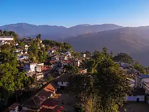 Maisthan, Mahottari | |
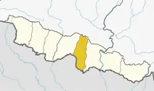 Mahottari District (dark yellow), in Province No. 2 | |
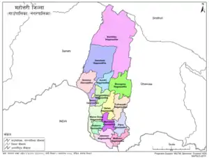 Mahottari District with local level body | |
| Country | |
| Province | Province No. 2 |
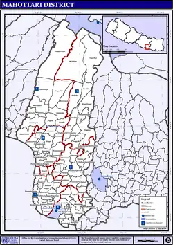
| Admin HQ. | Jaleshwar |
| Government | |
| • Type | Coordination committee |
| • Body | DCC, Mahottari |
| Area | |
| • Total | 1,002 km2 (387 sq mi) |
| Population (2011) | |
| • Total | 627,580 |
| • Density | 630/km2 (1,600/sq mi) |
| Time zone | UTC+05:45 (NPT) |
| Telephone Code | 044 |
| Main Language(s) | Maithili (88.0%), Nepali (5.6%), other (6.4%) |
| Website | ddcmahottari |
Geography and Climate
| Climate Zone[2] | Elevation Range | % of Area |
|---|---|---|
| Lower Tropical | below 300 meters (1,000 ft) | 85.0% |
| Upper Tropical | 300 to 1,000 meters 1,000 to 3,300 ft. |
15.0% |
Demographics
At the time of the 2011 Nepal census, Mahottari District had a population of 627,580. Of these, 80.7% spoke Maithili, 7.3% Urdu, 5.6% Nepali, 1.9% Magar, 1.4% Tamang, 1.1% Tharu and 0.9% Magahi as their first language.
35.1% of the population in the district spoke Hindi, 23.0% Nepali, 3.6% Maithili and 1.3% Urdu as their second language.[3]
Administration
The district consists of ten urban municipalities and five rural municipalities. These are as follows:[4]
- Aurahi Municipality
- Balawa Municipality
- Bardibas Municipality
- Bhangaha Municipality
- Gaushala Municipality
- Jaleshwor Municipality
- Loharpatti Municipality
- ManaraShiswa Municipality
- Matihani Municipality
- Ramgopalpur Municipality
- Ekdara Rural Municipality
- Mahottari Rural Municipality
- Pipara Rural Municipality
- Samsi Rural Municipality
- Sonama Rural Municipality
Former Village Development Committees (VDCs) and Municipalities
The 2011 National Population and Housing Census by the government of Nepal identifies 77 municipalities and village development committees (VDC) within the Mahottari District.[5]
References
- Household and population by districts, Central Bureau of Statistics (CBS) Nepal Archived 2013-09-27 at the Wayback Machine
- The Map of Potential Vegetation of Nepal - a forestry/agroecological/biodiversity classification system (PDF), Forest & Landscape Development and Environment Series 2-2005 and CFC-TIS Document Series No.110., 2005, ISBN 87-7903-210-9, retrieved Nov 22, 2013
- 2011 Nepal Census, Social Characteristics Tables
- "स्थानिय तह". 103.69.124.141. Archived from the original on 2018-08-31. Retrieved 2018-12-06.
- National Planning Commission Secretariat (November 2012). "National Population and Housing Census 2011" (PDF). Central Bureau of Statistics. Government of Nepal. pp. 27–28. Archived from the original (PDF) on 27 September 2013. Retrieved 3 May 2015.
- "Districts of Nepal". Statoids.
| Wikimedia Commons has media related to Mahottari District. |
Places adjacent to Mahottari District | ||||||||||
|---|---|---|---|---|---|---|---|---|---|---|
| ||||||||||
Headquarter: Jaleshwar | ||
| Municipalities: | | |
| Rural Municipalities: | ||
