Janakpur
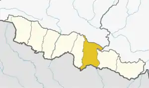
Janakpurdham or Janakpur (Nepali: जनकपुर, Nepali pronunciation: [d͡zʌnʌkpur]) is a sub-metropolitan city in Dhanusa District, Province No. 2, Nepal. The city is a hub for religious and cultural tourism. It has been declared as the temporary capital for Province No. 2 until the Province Assembly votes for a permanent capital.[1]

Janakpurdham
जनकपुरधाम | |
|---|---|
Capital metropolitan city | |
    Clockwise from top Janaki Mandir, Ganga Sagar, an Inarwa-Kurtha service train in Janakpur and Vivah Mandap | |
| Motto(s): City of religious and cultural significance | |
 Janakpurdham Location in Province No. 2  Janakpurdham Janakpurdham (Nepal) | |
| Coordinates: 26°43′43″N 85°55′30″E | |
| Country | Nepal |
| District | Dhanusha District |
| Government | |
| • Mayor | Mr. Lal Kishor Sah (RJPN) |
| • Deputy Mayor | Mrs. Rita Kumari Mishra (RJPN) |
| Area | |
| • Total | 100.20 km2 (38.69 sq mi) |
| Elevation | 74 m (243 ft) |
| Population (2015) | |
| • Total | 173,924 |
| • Density | 1,700/km2 (4,500/sq mi) |
| Demonym(s) | Maithil, Janakpuriya |
| Languages | |
| • Official | Maithili |
| Time zone | UTC+5:45 (NST) |
| Postal code | 45600 |
| Area code(s) | 041 |
| Website | http://janakpurmun.gov.np |
The city was founded in the early 18th century. According to tradition, storytelling indicates an earlier city known as Janakpurdham existed in the area, which was supposedly the capital of the Videha dynasty that ruled the Mithila region in ancient times.[2]

Janakpur is located about 225 km (140 mi) southeast of Kathmandu.[3] As of 2015, the city had a population of 173,924, making it the largest sub-metropolitan city of Nepal.[4] Janakpur is currently the third largest city in the Terai (after Biratnagar and Birgunj) and the seventh largest in Nepal.
Nepal Railways used to operate between Janakpur and India.
History
Accounts from ascetics, pandits, and bards indicate that Janakpur was founded in the early 18th century. The earliest description of Janakpur as a pilgrimage site dates to 1805. Earlier archaeological evidence of the presence of an ancient city has not been found. King Janaka's palace is thought to have been located in ancient Janakpur as it is believed to be the capital of the Kingdom of the Videhas. According to Ramayana, he found a baby girl in a furrow, named her Sita, and raised her as his daughter. When she was older, he offered her in marriage to anyone who was able to lift the bow of Shiva, left near Janakpur a thousand years earlier. Many royal suitors tried but only Rama, the prince of Ayodhya, could lift the bow. According to an old song, this bow was found northeast of Janakpur.[2]
Until the 1950s, Janakpur was a cluster of rural hamlets inhabited by farmers, artisans, priests, and clerks who worked for the monasteries that controlled the land. After the Independence Act in India, Janakpur expanded into a commercial center and became the capital of the Dhanusa District in the 1960s.[5]

As Rama and Sita are major figures in Hinduism, Janakpur is an important pilgrimage site for Hindus. According to the first millennium BC text, Shatapatha Brahmana, the Maithil king Videgha Māthava crossed the Sadānirā (Gandaki River), led by his priest Gotama Rahugana, and founded the Kingdom of Videha with Janakpur as the capital city. As Gotama Rahugana composed many hymns of the Rigveda, these events must date to the Regvedic period.[6]
Gautama Buddha and Vardhamana Mahavira, the 24th and final Tirthankara of the Jain religion are said to have lived in Janakpur. The region was an important center for the history of Mithila during the first millennium.[7]
Geography and climate
Janakpur is located in the Terai, where the climate is humid subtropical: the months of March and April are hot, dry and windy. The wet season lasts from May to September, followed by mild dry autumn from October to November. It is a cold winter from December to February.[5]
The major rivers surrounding Janakpur are Dudhmati, Jalad, Rato, Balan, and Kamala.
| Climate data for Janakpur Airport (1981-2010) | |||||||||||||
|---|---|---|---|---|---|---|---|---|---|---|---|---|---|
| Month | Jan | Feb | Mar | Apr | May | Jun | Jul | Aug | Sep | Oct | Nov | Dec | Year |
| Average high °C (°F) | 22.2 (72.0) |
26.0 (78.8) |
31.2 (88.2) |
34.8 (94.6) |
34.6 (94.3) |
34.1 (93.4) |
32.5 (90.5) |
32.7 (90.9) |
32.3 (90.1) |
31.7 (89.1) |
29.3 (84.7) |
25.1 (77.2) |
30.5 (86.9) |
| Daily mean °C (°F) | 15.6 (60.1) |
18.6 (65.5) |
23.4 (74.1) |
27.7 (81.9) |
29.3 (84.7) |
30.0 (86.0) |
29.3 (84.7) |
29.6 (85.3) |
28.8 (83.8) |
26.8 (80.2) |
22.5 (72.5) |
18.0 (64.4) |
25.0 (77.0) |
| Average low °C (°F) | 9.1 (48.4) |
11.3 (52.3) |
15.5 (59.9) |
20.6 (69.1) |
24.0 (75.2) |
25.9 (78.6) |
26.1 (79.0) |
26.4 (79.5) |
25.3 (77.5) |
22.0 (71.6) |
15.7 (60.3) |
10.9 (51.6) |
19.4 (66.9) |
| Average precipitation mm (inches) | 11.7 (0.46) |
11.4 (0.45) |
11.5 (0.45) |
52.2 (2.06) |
128.3 (5.05) |
238.7 (9.40) |
487.6 (19.20) |
339.4 (13.36) |
197.5 (7.78) |
63.9 (2.52) |
1.9 (0.07) |
8.4 (0.33) |
1,552.5 (61.12) |
| Source: [8] | |||||||||||||
Economy
Janakpur is one of the fastest developing cities of Nepal and is the largest sub-metropolitan city in the country.[9] The city has good health care facilities, a number of parks, private schools, colleges, and internet service providers. There are medical, engineering, and management colleges that are affiliated to Tribhuvan University. The economy is mostly based on tourism, agriculture, and local industries.
The paintings on pottery, walls, and courtyards made by Maithili women are known as Mithila art.
Janakpur attracts migrants from the surrounding area, moving to the city for medical care, education and jobs. The largest employers were the Janakpur Cigarette Factory Limited and Janakpur Railway until they closed in 2013 due to political corruption and heavy loans. By the end of 2018 Janakpur Railways resumed service.[10] Zonal Hospital, Zonal Police, and the Banking Sector help the locals live a relatively easy lifestyle.
The city has many commercial banks, such as Nepal Rastra Bank, the State Bank of India, Nepal, Everest Bank LTD. Machhapuchhare, NIC Bank, Nepal Bank LTD, and Agriculture Development Bank.
Transport
Roadways
Frequent bus services operate between Janakpur and Nepalese cities. Within the city, cycle rickshaws, electric rickshaws, tempos (three-wheeled vehicle), and buses are available.
Railways

Nepal Railways is the only operational railway in Nepal. It connects Janakpur to Siraha at the Nepal-India border and goes further to the Indian city of Jaynagar, Bihar. There is a customs checkpoint in Siraha for goods.[10]
Airways

Janakpur has a domestic airport (IATA: JKR, ICAO: VNJP) with most flights connecting to Kathmandu.[11]
| Airlines | Destinations |
|---|---|
| Buddha Air | Kathmandu [12] |
| Yeti Airlines | Kathmandu [13] |
| Shree Airlines | Kathmandu [14] |
Demographics
As of June 2011, the Janakpur municipality had 19,195 households and a population of 98,446 people with a density of 4,000 people per square kilometer.[15] In 2015, it was declared a sub-metropolitan city that incorporates 11 surrounding villages. The current population is 173,924 people, making it the sixth largest city in Nepal.[16]
Maithili is widely spoken in the area as the first language and is also used as the lingua franca. Nepali, Hindi, Marwari, and English are well understood. Languages like Bhojpuri and Awadhi are understood but less frequently used.
More than 90 percent of the total population is Hindu, with the rest being Muslims and Buddhists.
Culture
Religious sites
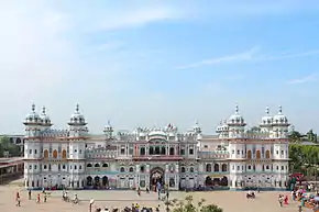
The Janaki Mandir temple is in the centre of Janakpur, northwest of the bazaar. It is one of the biggest temples in Nepal, and was built in 1898 (1955 in the Nepali calendar) by Queen Brisabhanu Kunwari of Tikamgarh. It is also called Nau Lakha Mandir after the cost of construction, said to be nine lakh rupees.[17] The temple is architecturally unique in Nepal: its inner sanctum contains a flower-covered statue of Sita that was found in the Sarayu near Ayodhya. Statues of Rama and his half-brothers Lakshman, Bharat, and Satrughna stand by Sita.
Adjacent to the Janaki Mandir is the Rama Sita Vivaha Mandir, a building that marks the event in which Rama and Sita were married.
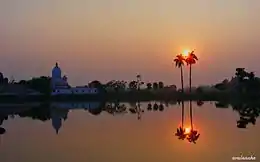
The oldest temple in Janakpur is Sri Ram Temple, built by the Gorkhali General Amar Singh Thapa.[17] Pilgrims also visit the over 200 sacred ponds in the city for ritual baths. The two most important ponds – Dhanush Sagar and Ganga Sagar, are located close to the city center.
Other religious sites include the Vivah Mandap temple situated next to the Janaki Mandir, and Ram Tower, which was inaugurated by former Prime Minister Sushil Koirala, located to the south of Ram Temple.
 Deities of Sri Sita Devi (far right) and Sri Rama (centre) (with Sri Lakshmana (far left) and Sri Hanuman (below seated))
 Pond in front of Mani mandap, Rani bazar. The place where the marriage of Ram and Sita actually happened.
 Ram Janaki Biwaha Mandap
 Hanuman Mandir, Kadam Chowk
 Janaki Mandir
Festivals
Major religious celebrations include the Hindu festivals Vivaha Panchami, Dipawali, and Vijayadashami,[17] followed by Chhath Puja, which is celebrated six days after Diwali and Makar Sankranti.
On the night of the full moon in February and March, before the festival of Holi, a one-day Parikrama (circumambulation) of the city is celebrated. Many people offer prostrated obeisances along the entire 8 km (5.0 mi) route. Two other festivals honour Rama and Sita: Rama Navami, the birthday of Lord Rama,[18] and the Vivah Panchami that re-enacts the wedding of Rama and Sita at the Vivah Mandap temple on the fifth day of the waxing moon in November or early December.
Education
Janakpur has educational facilities where several of the country's elites went to school, including the first president of the Federal Republic of Nepal, Ram Baran Yadav. There are many private and government schools and colleges located in Janakpur. The oldest government school for higher studies is Ramsworup Ramsagar Bahumukhi Campus (RR Multiple Campus), which is affiliated with Tribhuvan University.
Janakpur also has a medical college, Janaki Medical College,[20] which is also affiliated with Tribhuvan University.
Libraries
Gangasagar Public Library was established in 1955 and is situated between two historical ponds of Janakpur—Dhanuschatra Pond and Ganga Sagar. The library was reopened to the public in 2012. In recent times, a team of active and committed local youth workers have contributed to the revival of this library by organizing public book collections for the library. It is open daily for three hours, mainly for newspaper-reading but has few daily visitors.[21]
Ramswaroop Ramsagar Multiple Campus Library is also accessible to the general public.
Media
The local media of Janakpur primarily consists of several community radio stations, some TV channels, and a few print newspapers, such as Janakpur Today. Local Janakpur media primarily consists of radio shows, such as Mithila Jagaran.
2015 Nepal earthquake
According to Colin Stark at Columbia University, during the earthquake on 25 April 2015, "[a] part of India slid about one foot to 10 feet northwards and underneath Nepal in a matter of seconds. The part below Bihar slid under Nepal along a zone from Bharatpur, through Hetauda, to Janakpur."[22]
See also
References
- "Places proposed for temporary capitals of all seven provinces". kathmandutribune.com. 2 January 2018. Archived from the original on 22 June 2018. Retrieved 2 January 2018.
- Burghart, R. (1978). The disappearance and reappearance of Janakpur. Kailash: A Journal of Himalayan Studies 6 (4): 257–284.
- "Distance from Kathmandu to Janakpur". www.distancefromto.net. Archived from the original on 25 March 2016. Retrieved 8 September 2018.
- "Archived copy" (PDF). Archived from the original (PDF) on 31 July 2013. Retrieved 16 April 2015.CS1 maint: archived copy as title (link)
- Burghart, R. (1988.) Cultural knowledge of hygiene and sanitation as a basis for health development in Nepal. Contributions to Nepalese Studies 15 (2): 185–211.
- "Nepal-India relations: Ramayan circuit". The Himalayan Times. 22 November 2017. Archived from the original on 7 December 2018. Retrieved 7 December 2018.
- Rastriya Samachar Samiti (2004). "More Indian tourists visit Janakpurdham" Archived 2 August 2017 at the Wayback Machine. Himalayan Times, 17 January 2004.
- Department of Hydrology and Meteorology 2014 Archived 19 August 2019 at the Wayback Machine.
- "स्थानिय तह". 103.69.124.141. Archived from the original on 31 August 2018. Retrieved 7 December 2018.
- "Janakpur railway nears completion". kathmandupost.ekantipur.com. Archived from the original on 7 December 2018. Retrieved 7 December 2018.
- Magar, Arpana Ale. "India permits new air entry routes over Biratnagar, Janakpur". My Republica. Archived from the original on 7 December 2018. Retrieved 7 December 2018.
- "Flight schedule". Buddha Air. Archived from the original on 18 September 2010. Retrieved 6 June 2010.
- "Scheduled flights". Yeti Airlines. Archived from the original on 10 June 2010. Retrieved 6 June 2010.
- "Flight schedule". Shree Airlines. Retrieved 6 June 2010. Unknown parameter
|archive-
url=
ignored (help) - Central Bureau of Statistics (2012). National Population and Housing Census 2011 (PDF). Kathmandu: Government of Nepal. Archived (PDF) from the original on 26 July 2018. Retrieved 18 June 2017.
- "National Population and Housing Census 2011 - (Village Development Committee/Municipality) - Dhanusha" (PDF). Government of Nepal, National Planning Commission Secretariat, Central Bureau of Statistics. March 2014. Archived (PDF) from the original on 2 September 2018. Retrieved 7 December 2018. Cite journal requires
|journal=(help) - Mishra, K. C. (1996). Pilgrimage centres and tradition in Nepal. In: D. P. Dubey (ed) Rays and Ways of Indian Culture. M.D. Publications Pvt. Ltd., New Delhi.
- "Archived copy". Archived from the original on 6 September 2011. Retrieved 25 July 2011.CS1 maint: archived copy as title (link)
- "MoU on Twinning arrangements between Kathmandu-Varanasi, Janakpur-Ayodhya and Lumbini-Bodh Gaya as sister cities". pib.gov.in. Archived from the original on 23 August 2020. Retrieved 8 March 2020.
- "Janaki Medical College". Archived from the original on 18 March 2018. Retrieved 8 September 2018.
- Mishra, P. "Book Collection and Donation Program". Archived from the original on 23 August 2020. Retrieved 27 March 2016.
- "'Part of India slid underneath Nepal'". The Hindu. 29 April 2015. Archived from the original on 1 May 2015. Retrieved 5 November 2016.
External links
| Wikivoyage has a travel guide for Janakpur. |
| Wikimedia Commons has media related to Janakpur. |
Places adjacent to Janakpur | ||||||||||
|---|---|---|---|---|---|---|---|---|---|---|
| ||||||||||